
Forty kilometers from where the earth ruptured with devastating force in 2011, the Aleutian Islands trembled once again on Friday, May 22, 2026, as a magnitude 5.6 earthquake rippled through the remote Pacific arc. The shallow temblor struck at 12:16 UTC roughly 173 kilometers east of Atka, Alaska, according to the USGS Earthquake Hazards Program, releasing energy practically on top of the epicenter of a destructive M6.9 event that fractured the seafloor fifteen years prior. This latest jolt serves as a stark reminder that the grinding tectonic machinery beneath the Bering Sea never truly stops.
Why Is This Area So Seismically Active?
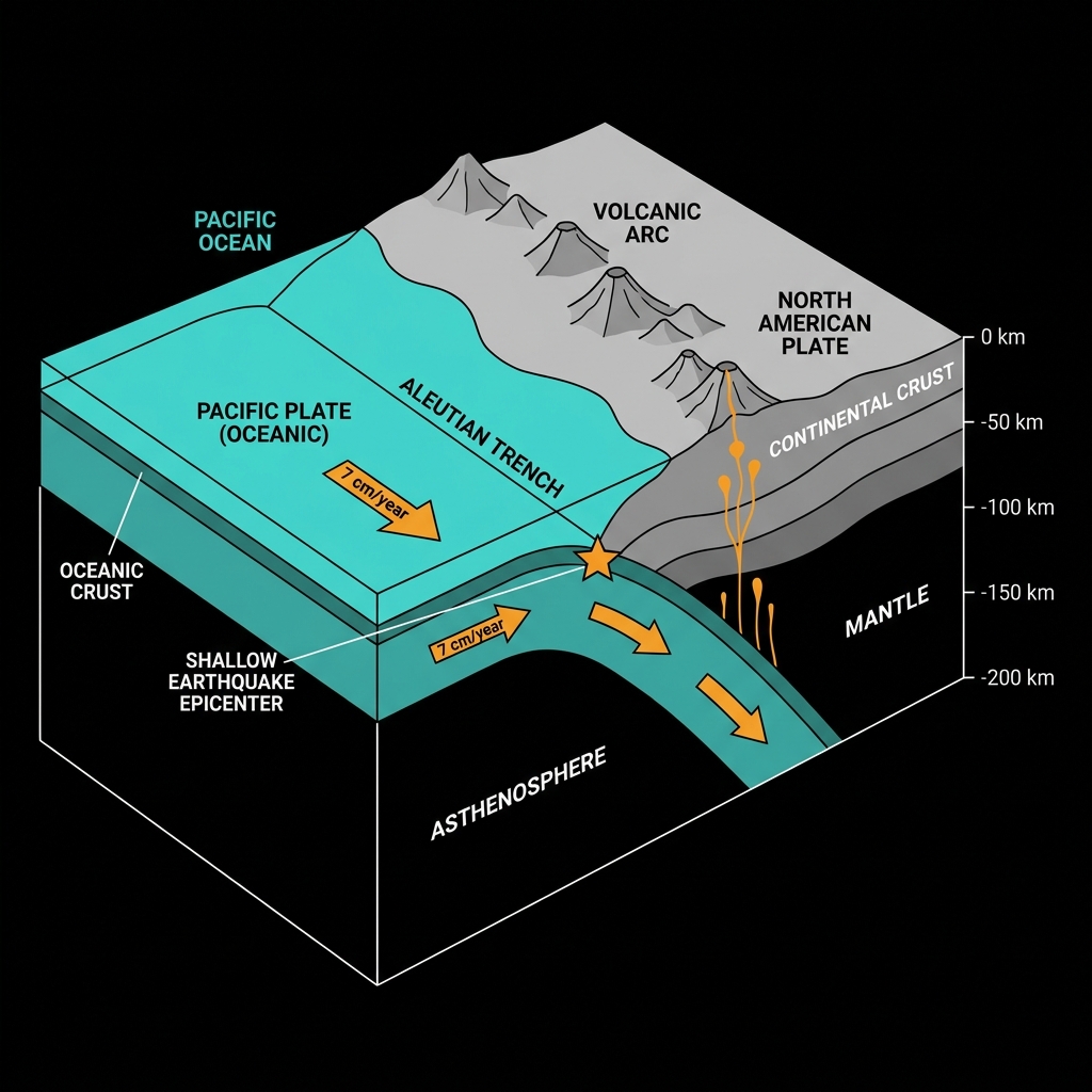
The Aleutian Islands mark the surface expression of a violent geological marriage: the Pacific Plate diving beneath the North American Plate along the Aleutian Trench at a rate of several centimeters per year. This subduction process creates one of the world’s most productive earthquake factories, where strain accumulates for decades before releasing in sudden ruptures. The region is currently experiencing a lull in major activity compared to the intense clustering of 2011, which saw both a M7.3 and the M6.9 near Friday’s epicenter. Yet the earth has not been entirely silent; in the past week alone, two smaller earthquakes have rattled the arc, including a magnitude 4.0 event nearly 230 kilometers deep, hinting at ongoing adjustments within the subducting slab.
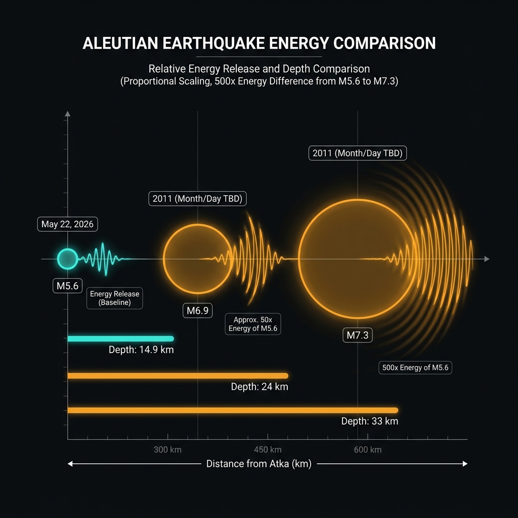
Historical records reveal a relentless rhythm of significant events. Since 1987, this stretch of the arc has hosted ten earthquakes of magnitude 6.0 or greater within 200 kilometers of Friday’s epicenter, ranging from a M6.2 in 1987 to the powerful M7.3 Fox Islands event that struck just 53 kilometers away in 2011.
How Strong Was the Shaking?
At a depth of just 14.9 kilometers, this earthquake qualifies as shallow—occurring within the upper crust rather than along the deeper plate interface. Seismologists classify such events as crustal or upper-plate earthquakes, and they typically produce sharper, more localized shaking than deeper tremors of equivalent magnitude. While a M5.6 can cause significant damage in populated areas, this event’s offshore location—173 kilometers from Atka—limited its impact. The shaking likely felt like a moderate jolt to any vessels in the immediate vicinity, comparable to the sudden braking of a subway train, but attenuated rapidly across the oceanic crust.
| Event | Year | Magnitude | Distance from May 22 Epicenter | Depth |
|---|---|---|---|---|
| Fox Islands | 2011 | 7.3 | 53 km | ~33 km |
| Near Atka | 2011 | 6.9 | 40 km | ~24 km |
| May 22, 2026 | 2026 | 5.6 | 0 km | 14.9 km |
When placed alongside its 2011 neighbors, Friday’s earthquake represents a fractional release of stored energy—roughly 25 times less powerful than the M6.9 and 500 times weaker than the M7.3. Nevertheless, it occupies the same shallow crustal volume, suggesting the local fault structure remains stressed. This type of earthquake tells us that the overriding North American plate is experiencing internal deformation, independent of the deeper megathrust cycle. Seismologists classify this as an upper-plate event, distinguishing it from the plate-interface ruptures that generate the region’s largest tsunamis.
For residents of Atka, Nikolski, and the fishing fleets operating in these waters, the immediate protocol involves checking structures for fresh hairline cracks in drywall or concrete, particularly in buildings that weathered the 2011 sequence. Secure heavy furniture and verify that satellite phones and emergency beacons remain charged, as standard cellular infrastructure is nonexistent this far west. While the USGS confirmed no tsunami warning was necessary, maintain situational awareness for several hours following any significant Aleutian quake, as these waters have produced destructive waves in the past.
What Should We Watch For?
The USGS will continue monitoring for aftershocks, though detecting smaller tremors in this remote stretch of the Pacific relies on sparse ocean-bottom sensors. Historically, earthquakes of this magnitude in the western Aleutians produce sequences of smaller aftershocks decaying over days to weeks. The event does not indicate an immediate precursor to a larger rupture, but rather reflects the steady, inexorable deformation of a boundary that produced magnitude 8+ events in 1957 and 1965. Keep watch for any rapid succession of tremors or unusual volcanic unrest at nearby Mount Cleveland, as seismic swarms here sometimes presage broader tectonic shifts.
Frequently Asked Questions
How strong was this earthquake?
The earthquake registered magnitude 5.6 on the moment magnitude scale, classifying it as a moderate event. It released approximately 3.5 petajoules of seismic energy, roughly equivalent to 800 tons of TNT, though its shallow depth meant the shaking felt more intense locally than a deeper quake of the same size.
Is there a tsunami risk?
According to USGS data, this earthquake posed no tsunami threat. Tsunamis typically require vertical seafloor displacement during earthquakes larger than magnitude 7.0, or submarine landslides, neither of which were detected here.
Why is this area so seismically active?
The Aleutian Islands sit above the Aleutian Trench, where the Pacific Plate subducts beneath Alaska at a rate of about 7 centimeters per year. This tectonic collision generates continuous strain, producing frequent earthquakes ranging from small tremors to magnitude 8+ megathrust events that reshape the archipelago.
Track this event live on the map!
Download GeoShake and get instant earthquake alerts.
Download GeoShake