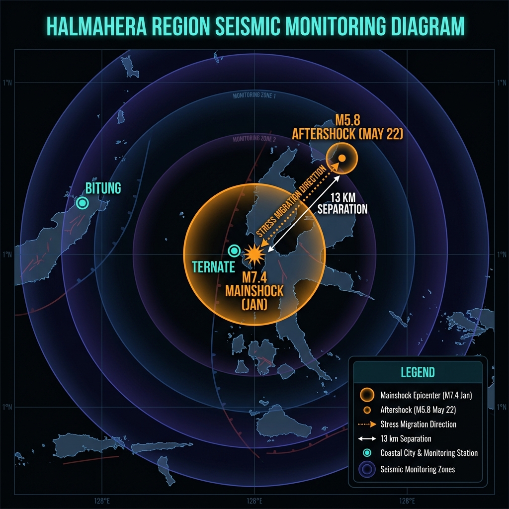
Just 13 kilometers from the scarred epicenter of a catastrophic magnitude 7.4 earthquake that shattered communities in January, the earth shook again. In the pre-dawn hours of May 22, 2026, a magnitude 5.8 tremor struck 116 kilometers east-southeast of Bitung, Indonesia, according to USGS data, sending fresh waves of anxiety through a region still clearing rubble from the deadliest seismic event of the year. The quake ruptured at a depth of 47.7 kilometers beneath the Molucca Sea, close enough to the January mainshock’s origin point that seismologists immediately flagged it as part of an intensifying aftershock sequence rather than an isolated incident.
Why Is This Corner of the Molucca Sea So Dangerous?
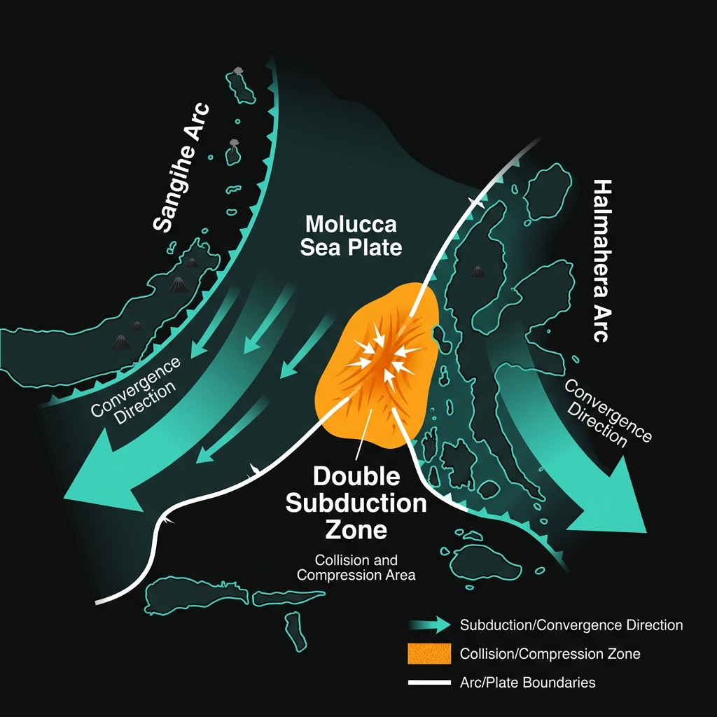
The Molucca Sea collision zone represents one of the most complex tectonic puzzles on Earth. Here, two volcanic island arcs—the Sangihe Arc to the west and the Halmahera Arc to the east—are actively colliding, creating a rare “double subduction” system where oceanic plates dive beneath both margins simultaneously. This convergence generates extreme compression, making the region a factory for powerful earthquakes.
The area has produced six magnitude 7-plus events since 1986 alone, including the devastating M7.5 temblor in 2007 that struck just 19 kilometers from today’s epicenter. When these buried plates slip, they release stress accumulated over centuries, often in violent clusters that can persist for months.
How Does Depth Change the Danger?
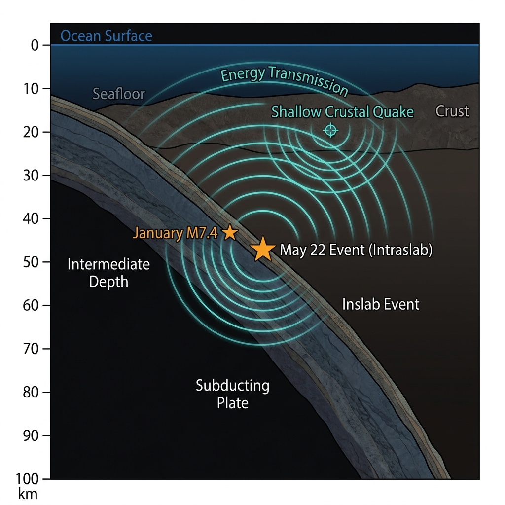
At 47.7 kilometers below the surface, this earthquake qualifies as an intermediate-depth event—born too deep to break the seafloor directly but shallow enough to transmit intense energy upward. Seismologists classify earthquakes at this depth as intraslab events, occurring within the descending oceanic plate rather than at the grinding boundary between plates.
For residents, this depth profile creates a specific hazard signature: the shaking spreads farther across the archipelago than it would from a shallow rupture, yet the intense jolts that topple unreinforced masonry tend to be less severe than those from shallow crustal quakes. During the January M7.4 mainshock, which struck at a comparable depth, strong shaking lasted nearly 90 seconds and damaged thousands of structures across Halmahera Island; today’s M5.8 delivers roughly 1/63rd of that energy, but its proximity to the earlier rupture zone raises concerns about compounding structural damage.
| Event | Magnitude | Depth | Distance from Today’s Epicenter | Date |
|---|---|---|---|---|
| Today’s Earthquake | 5.8 Mww | 47.7 km | — | May 22, 2026 |
| January Mainshock | 7.4 | ~45 km | 13 km | Jan 2026 |
| 2007 Halmahera Quake | 7.5 | ~20 km | 19 km | Feb 2007 |
| 2019 Ternate Event | 7.1 | ~60 km | 68 km | July 2019 |
This type of earthquake tells us the crust is still adjusting to January’s massive stress redistribution. Aftershock sequences in subduction zones typically follow a predictable decay pattern known as Omori’s Law, where the frequency of tremors decreases over time. However, the Molucca Sea’s unique collision geometry can produce “triggered” seismicity, where stress transfers to adjacent fault segments. The 13-kilometer separation between today’s epicenter and January’s rupture suggests stress may be migrating along the plate boundary, a phenomenon seismologists monitor closely for signs of subsequent larger events.
Residents in Bitung, Ternate, and surrounding islands should treat this as a critical reminder that the aftershock sequence remains active. Inspect homes and buildings immediately for fresh cracks or shifted foundations, particularly in structures already compromised by January’s shaking. Keep emergency kits accessible and establish family meeting points, as intermediate-depth quakes like this can generate sudden strong motion without the brief warning of distant P-waves that shallower events provide. Avoid entering damaged buildings until local emergency management teams complete safety assessments, and maintain communication devices charged in anticipation of potential infrastructure disruptions from subsequent jolts.
What Should We Monitor in the Coming Days?
The seismological community will be watching for two critical signals over the next 72 hours. First, any migration of epicenters toward populated coastal areas like Bitung or Ternate would suggest the aftershock sequence is exploring new fault segments. Second, a noticeable increase in the rate of M4+ events could indicate the system has not yet settled into the typical post-mainshock decay pattern. While the probability of another M7+ event decreases with each passing day, the region’s history—including the 2019 M7.1 and M6.9 pair that struck within months of each other—demonstrates that the Molucca Sea collision zone can harbor multiple damaging sequences. GeoShake will continue monitoring this swarm as the situation evolves.
Frequently Asked Questions
How strong was this earthquake compared to the January event?
A magnitude 5.8 earthquake releases approximately 63 times less energy than a magnitude 7.4 event. While today’s tremor caused significant local shaking, it lacked the destructive power of January’s mainshock, which damaged thousands of buildings across the Halmahera region.
Is there a tsunami risk from this earthquake?
No tsunami warning was issued for this event. The earthquake occurred at intermediate depth (47.7 km) within the subducting plate, and initial USGS analysis indicates no significant seafloor displacement occurred that would displace ocean water and generate tsunami waves.
Why does this specific area produce so many large earthquakes?
The Molucca Sea sits at the collision point of two volcanic island arcs, creating a rare double subduction zone where tectonic plates converge from both east and west. This extreme compression generates some of the highest seismic productivity on Earth, with six magnitude 7-plus earthquakes recorded in this region since 1986 alone.
Track this event live on the map!
Download GeoShake and get instant earthquake alerts.
Download GeoShake