
At 12.4 kilometers beneath the sparkling surface of the Aegean Sea, a patch of crust the size of a city block suddenly lurched sideways, releasing centuries of stored elastic energy in a split second. The movement generated a magnitude 4.3 jolt that rippled through the water column at 1:34 PM UTC on May 23, according to USGS data, striking a spot roughly 136 kilometers west of the sun-bleached shores of Datça, Turkey. Though modest by tectonic standards, the shallow depth placed the energy release squarely within the brittle upper crust—close enough to send subtle tremors through the ancient marble coastlines that have witnessed millennia of Mediterranean seismicity, yet distant enough to leave the harbor towns largely undisturbed.
Why Is This Area So Seismically Active?
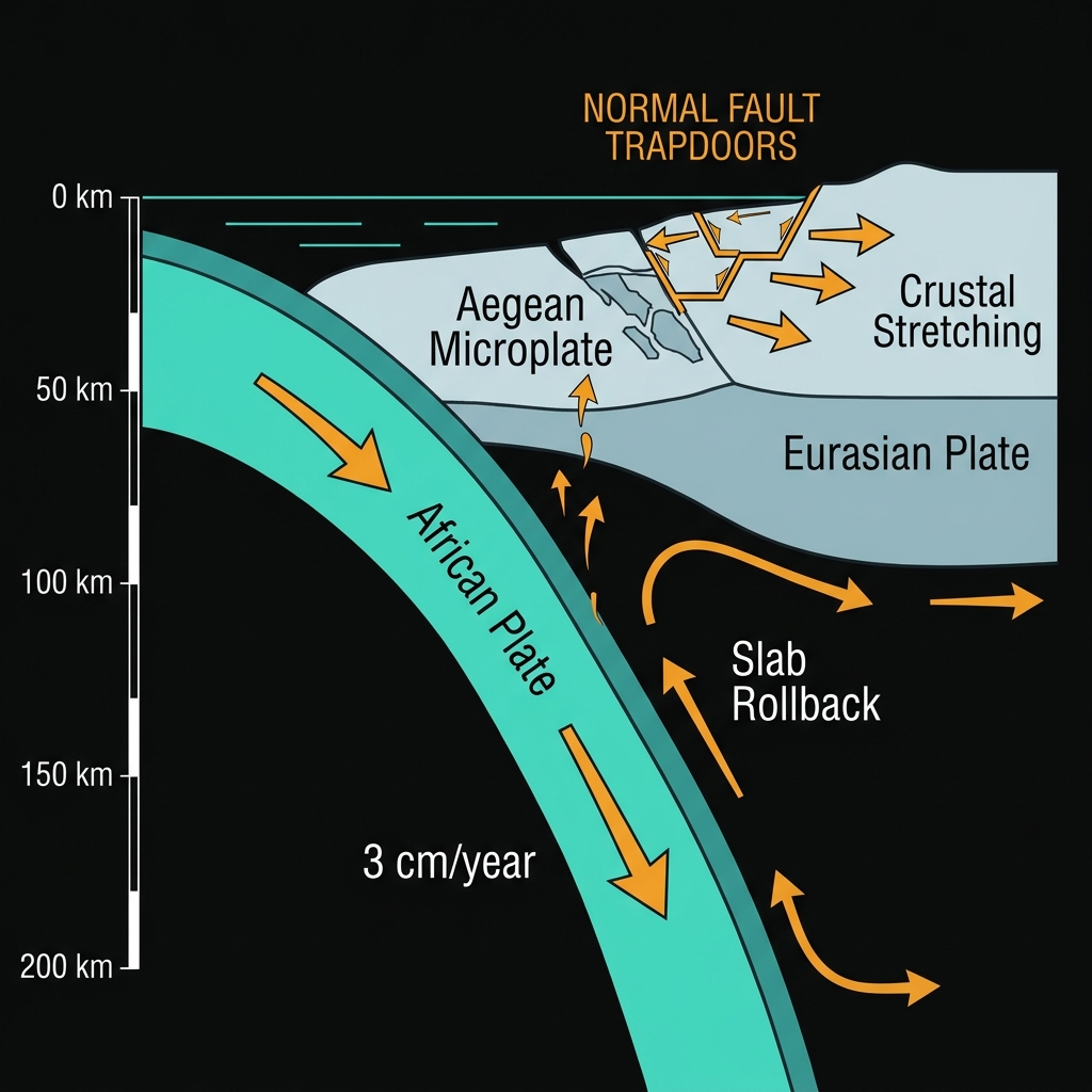
The Aegean Sea is not merely a postcard backdrop; it is a geologically youthful basin being actively ripped apart by the slow-motion retreat of the Hellenic subduction zone. Here, the African Plate dives northward beneath the Eurasian Plate, dragging the edge of the overriding Aegean microplate with it like a carpet sliding off a table. This process, known as slab rollback, creates a powerful stretching force across the region that opens normal faults—vertical fractures where crustal blocks drop downward relative to each other like trapdoors. The African Plate descends at roughly three centimeters per year, about the speed at which fingernails grow, yet this inexorable motion builds stress across millennia. Datça sits perched on the Anatolian promontory, overlooking this underwater rift system where such extensional earthquakes are the norm rather than the exception, with fault scarps visible both on land beneath the olive groves and hidden beneath the azure waves.
How Far Did the Shaking Travel?
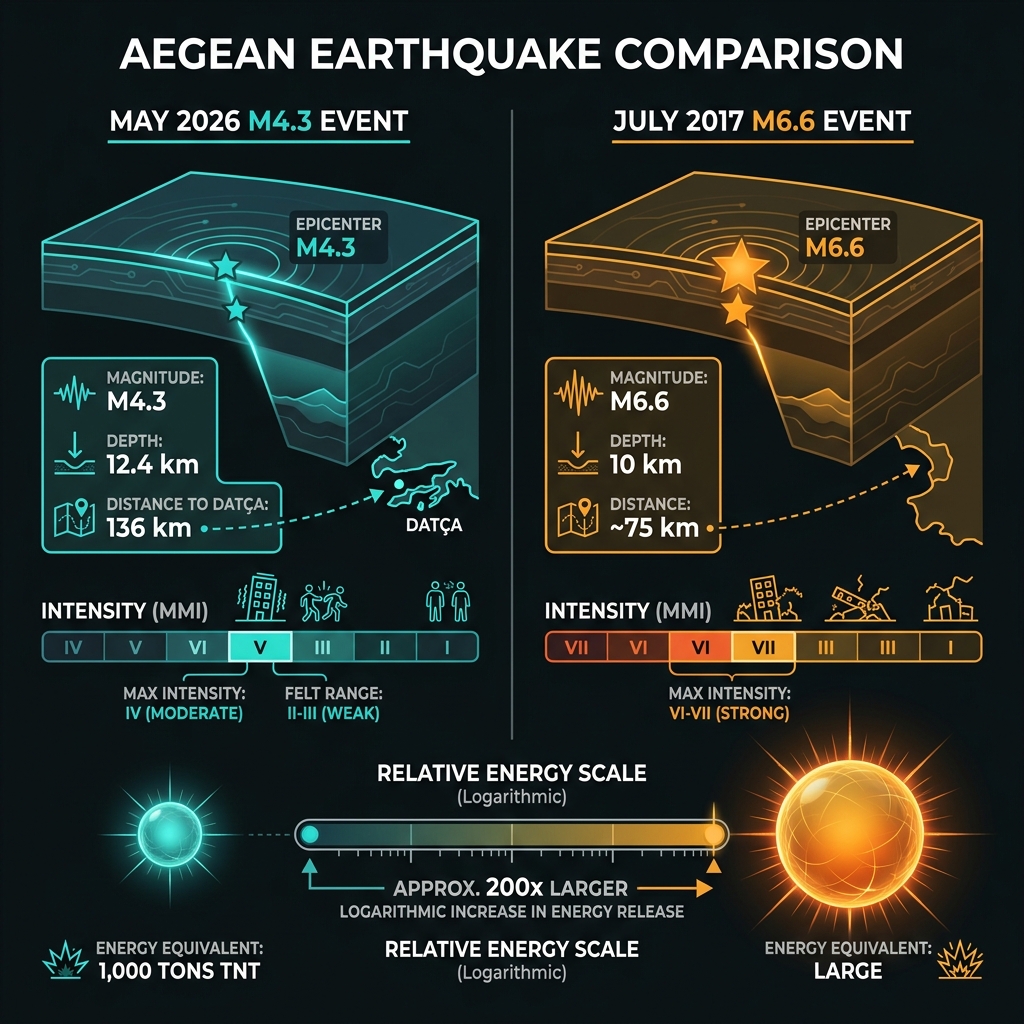
Distance is the great dampener of seismic energy. At magnitude 4.3, this event packed roughly the equivalent of 1,000 tons of TNT, but that power spread outward in all directions through the bedrock of the Aegean basin. Seismologists classify this as a shallow crustal earthquake—originating at 12.4 kilometers, well above the 70-kilometer threshold that defines “deep” events. Shallow quakes often feel sharper because less bedrock absorbs the high-frequency waves, yet Datça lay 135 kilometers away from the epicenter. On the Modified Mercalli Intensity scale, which measures felt effects rather than raw energy, this event likely registered as IV (Light) near the epicenter, transitioning to II-III (Weak) in Datça itself. Residents there might have noticed a brief, gentle swaying akin to a heavy truck passing, or perhaps nothing at all, whereas swimmers on nearby Greek islands could have felt the sea shift beneath them. The moment magnitude scale is logarithmic, meaning each whole number represents a tenfold increase in wave amplitude; this event was roughly 200 times smaller than the destructive magnitude 6.6 tremor that struck the region in 2017.
| Feature | May 23, 2026 Event | July 2017 Aegean Sea Earthquake |
|---|---|---|
| Magnitude | 4.3 MW | 6.6 MW |
| Depth | 12.4 km | 10 km |
| Distance from Datça | 135 km | ~75 km |
| Typical Intensity | Light (IV) to Weak (II-III) | Strong (VI) to Very Strong (VII) |
| Impact | No damage reported | 2 deaths, structural damage |
The fault mechanism likely involved normal faulting, typical for this extensional regime where the crust is being pulled apart. Seismologists note that while a 4.3 magnitude rarely causes structural failure, it serves as a tactile reminder of the region’s restless geology and helps refine stress models. Local building codes in Muğla province account for such sporadic shaking, requiring reinforced masonry that can withstand the region’s characteristic rumbles.
What Should We Watch For?
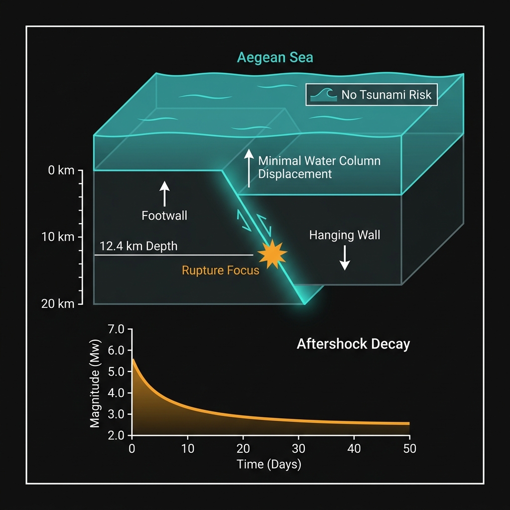
Aftershocks following a magnitude 4.3 event typically diminish in size and frequency over days or weeks, rarely exceeding magnitude 3.0. There is no tsunami threat from this particular rupture; the displacement occurred too deep and too small to perturb the water column significantly, a fact confirmed by ocean buoy networks. For GeoShake monitors, this event adds another data point to the Aegean stress map, helping refine models of how the African slab’s retreat reshapes the eastern Mediterranean seabed. Future tremors here will likely follow the same pattern—sudden, shallow, and serving as reminders that the Aegean is still stretching open, one subtle shift at a time.
Frequently Asked Questions
How strong was this earthquake?
The earthquake registered magnitude 4.3 on the moment magnitude scale, classifying it as a light event. While perceptible to people near the epicenter, it typically causes no damage to buildings and produces shaking comparable to a heavy vehicle passing nearby at distances exceeding 100 kilometers.
Is there a tsunami risk?
No tsunami was generated by this earthquake. Tsunamis generally require larger magnitudes—typically above 6.5—or significant underwater landslide mechanisms to displace substantial water volume. The 12.4-kilometer depth and moderate size of this event did not create the vertical seafloor displacement necessary to trigger ocean waves.
Why is this area so seismically active?
The Aegean Sea sits within a back-arc basin where the African Plate subducts beneath Eurasia, causing the overlying crust to stretch and thin. This extension creates normal faults that frequently slip, producing shallow earthquakes like this one along the Hellenic arc and surrounding Turkish coastlines.
Track this event live on the map!
Download GeoShake and get instant earthquake alerts.
Download GeoShake