
The ground beneath Hawaii’s Kona coast has trembled twenty-seven times in just seven days. The largest of these shocks—a magnitude 5.9 earthquake—struck 12 kilometers south of Honaunau-Napoopoo on Saturday morning at 7:46 a.m. local time, according to USGS data, rattling the populated western flank of the Big Island and climaxing an intense seismic swarm that suggests significant tectonic or magmatic stress beneath one of Earth’s most active volcanic systems. At a depth of 24.5 kilometers, the quake released energy equivalent to millions of kilograms of explosive force, sending sharp jolts through coffee plantations and coastal communities while renewing concerns about the geological instability lurking beneath Hawaii’s paradise veneer.
Why Is This Volcanic Region So Prone to Sudden Shakes?
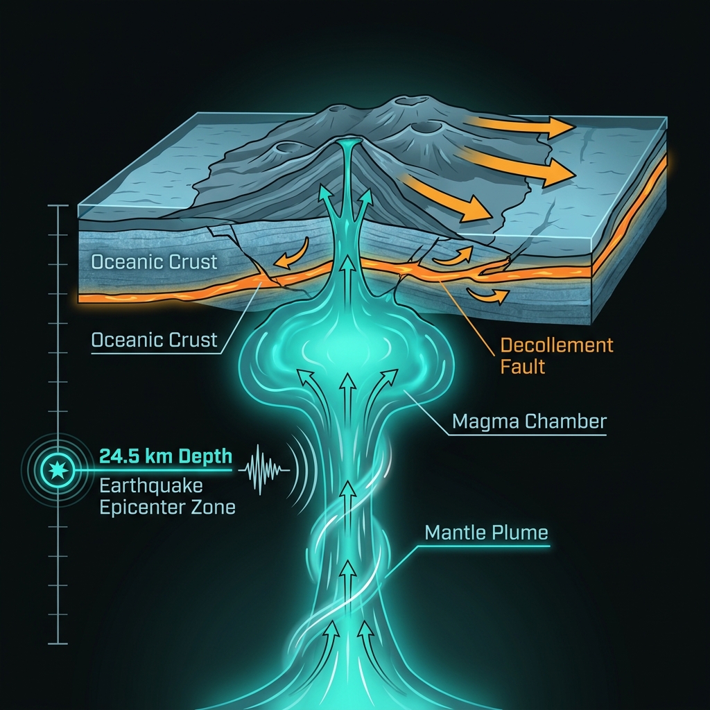
Hawaii exists because of a geological hotspot—a plume of superheated rock rising from deep within Earth’s mantle that has built the Big Island’s massive shield volcanoes over millions of years. This setting creates a unique seismic environment where earthquakes originate from two distinct mechanisms: the movement of magma through underground chambers and pipes, and the gravitational collapse of the volcanoes’ own immense weight as they spread outward and slip seaward along deep fault planes.
The epicenter lies in the vicinity of Mauna Loa and Kilauea, two of the world’s most active volcanoes. At 24.5 kilometers deep, this event likely occurred near the boundary between the volcanic edifice and the underlying ocean crust, a zone where magma transport and structural adjustments frequently generate tremors. Seismologists classify such mid-crustal earthquakes as particularly telling indicators of stress redistribution, whether from magma pressure changes or the slow, inexorable slippage of the massive mountain’s flank toward the Pacific Ocean.
Historical context underscores the region’s potential for larger events. The 2018 magnitude 6.9 earthquake near Leilani Estates—located 91 kilometers from today’s epicenter—remains the largest in Hawaii’s modern instrumental record, triggered by magma withdrawal from Kilauea’s summit. Similarly, the 2006 magnitude 6.7 event near Puako, just 60 kilometers away, resulted from structural failure along the volcano’s submarine flank. While Saturday’s quake was smaller, it fits a pattern of significant seismicity that has peppered the Big Island over the past four decades.
What Does This Depth and Magnitude Mean for Residents?
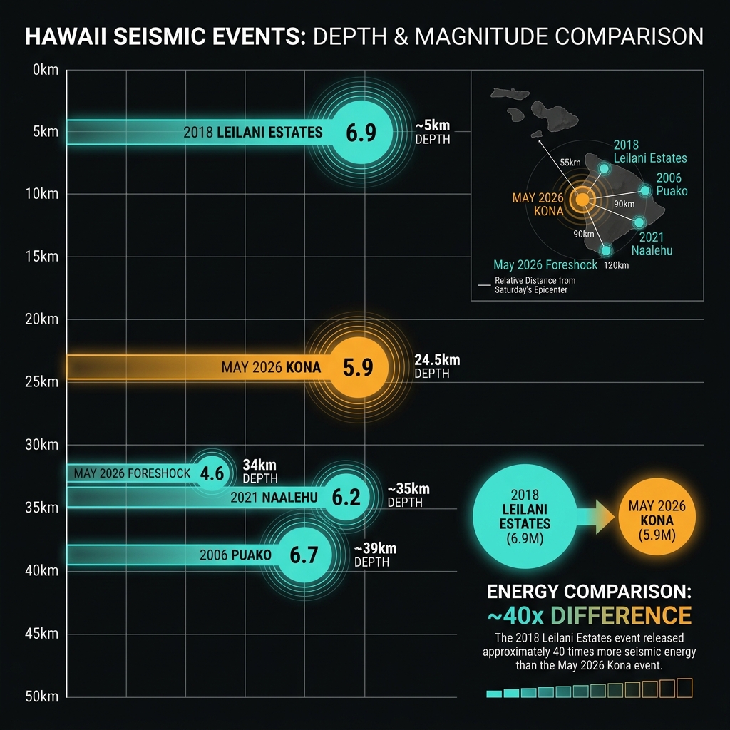
A magnitude 5.9 earthquake releases roughly 40 times less energy than the devastating 2018 event, yet its effects were widely felt across the Kona coast. The 24.5-kilometer depth placed the rupture within the brittle middle crust, meaning seismic waves had sufficient distance to attenuate slightly before reaching the surface, likely reducing the intensity of shaking compared to a shallower quake of similar size. Residents likely experienced strong shaking capable of knocking items from shelves and cracking plaster, though the region’s strict building codes and low-rise construction typically withstand such forces without catastrophic failure.
The absence of a tsunami warning, despite Hawaii’s vulnerability to ocean waves, stems from the earthquake’s depth and likely mechanism. Deep earthquakes rarely displace the seafloor vertically with sufficient speed to generate tsunamis, and strike-slip or normal faulting beneath the volcanic edifice—rather than the thrust faulting typical of subduction zones—minimizes water column displacement. Shaking reports indicated the tremor was felt as far as Hilo, 80 kilometers away, though with diminishing intensity.
Recent activity contextualizes Saturday’s event within an ongoing seismic pulse. The following table compares the current earthquake to other significant events in the region:
| Event | Magnitude | Depth | Distance from Saturday’s Epicenter | Context |
|---|---|---|---|---|
| May 23, 2026 | 5.9 | 24.5 km | — | Largest of 27-quake swarm, Kona coast |
| May 16-22, 2026 | Up to 4.6 | 34.0 km | ~10 km | Precursory swarm near Kahaluu-Keauhou |
| 2018 Leilani Estates | 6.9 | ~5 km | 91 km | Eruption-related, largest in modern record |
| 2006 Puako | 6.7 | ~39 km | 60 km | Flank collapse event |
| 2021 Naalehu | 6.2 | ~35 km | 68 km | Deep mantle faulting |
This type of earthquake tells seismologists that the volcanic system is actively adjusting, whether through magma migration or gravitational settling. The clustering of 27 events in one week—including a magnitude 4.6 foreshock near Kahaluu-Keauhou just days earlier—suggests a singular stress release episode rather than random, isolated failures.
What Should Kona Residents Do Right Now?
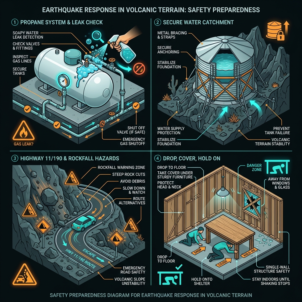
Given the active swarm and likelihood of additional shaking, residents should immediately inspect propane tanks and gas lines common in rural Kona homes for leaks, as volcanic rock terrain can shift and sever connections. Secure or brace water catchment tanks on unstable slopes, and avoid stopping or parking beneath steep rock cuts along Highway 11 and Highway 190 where aftershocks might dislodge loose volcanic material. Expect additional tremors in the coming hours and days; if indoors when shaking occurs, drop, cover, and hold on beneath sturdy furniture away from windows, as Hawaii’s single-wall construction offers less protection from falling debris than mainland masonry.
What Happens Next?
The coming days will prove critical for volcanologists monitoring the Big Island. If the earthquake swarm represents magma movement, GPS instruments across Mauna Loa and Kilauea should detect ground inflation or changes in gas emissions at summit vents. Should earthquakes migrate toward the surface or increase in magnitude beyond Saturday’s 5.9 event, the Hawaiian Volcano Observatory may elevate alert levels for volcanic unrest. For now, the region remains seismically restless, with GeoShake monitoring indicating that the tectonic pulse beneath Kona has not yet subsided.
Frequently Asked Questions
How strong was this earthquake compared to recent Hawaii quakes?
This magnitude 5.9 event ranks among the most powerful earthquakes to strike Hawaii in the past decade, though it remains smaller than the 2018 magnitude 6.9 Leilani Estates earthquake and the 2006 magnitude 6.7 Puako event. It represents the culmination of an unusual week-long swarm that produced 27 earthquakes, making it statistically significant as part of a clustered sequence rather than an isolated tremor.
Is there a tsunami risk from this earthquake?
No tsunami warning was issued because the earthquake’s 24.5-kilometer depth and volcanic setting make it unlikely to generate destructive ocean waves. Tsunamis typically require shallow, thrust-type earthquakes that abruptly lift the seafloor, whereas deep earthquakes beneath Hawaii’s volcanoes rarely displace sufficient water volume to create tsunamis.
Why is this area so seismically active?
Hawaii sits atop a geological hotspot where a mantle plume feeds active volcanoes, creating constant magma movement that fractures rock and generates earthquakes. Additionally, the massive weight of Mauna Loa and Kilauea causes the volcanoes to spread outward and slip seaward along deep fault planes, producing frequent tremors independent of magma activity.
Track this event live on the map!
Download GeoShake and get instant earthquake alerts.
Download GeoShake