
The ground beneath Hawaii’s Kona coast convulsed with brutal efficiency on Friday, as a magnitude 6.0 earthquake ruptured just 16 kilometers beneath the surface—shallow enough to transform subterranean stress into violent surface shaking across the Big Island’s tourist-heavy western shore. The temblor struck 6 kilometers east-southeast of Honaunau-Napoopoo, according to USGS data, sending tremors through coffee farms, resort districts, and coastal communities already jittery from a week-long seismic swarm. At this depth, seismic waves lose little energy before reaching the surface, meaning the shaking felt across Kona was significantly more intense than it would have been from a deeper quake of equivalent magnitude.
Why Is This Area So Seismically Active?
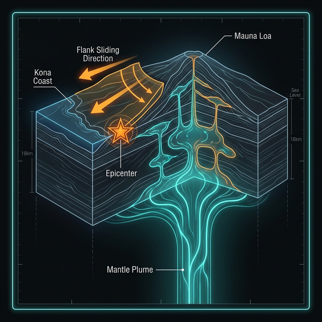
Hawaii occupies a unique position in the Pacific, perched atop a mantle plume—a concentrated upwelling of abnormally hot rock that generates the archipelago’s legendary volcanoes. Unlike California’s San Andreas or Japan’s subduction zones, where tectonic plates grind against each other, the Big Island’s earthquakes stem from the immense weight of massive shield volcanoes like Mauna Loa and Mauna Kea pressing down on the oceanic crust, coupled with magma moving through subsurface conduits. This geological setting creates a complex stress field where flank earthquakes—caused by the gradual seaward sliding of volcanic slopes—dominate the seismic record. The Kona coast sits particularly close to the western flank of Mauna Loa, Hawaii’s largest active volcano, placing it directly in the path of these gravitational stress releases.
The region bears the scars of previous significant events. In 2006, a magnitude 6.7 earthquake struck just 14 kilometers deep near Puako, roughly 52 kilometers from today’s epicenter, causing millions in damage and island-wide power outages. A similar M6.0 event hit near Hawi in 2006, while deeper historical shocks include a M6.2 in 1989 near Fern Forest and another M6.2 in 2021 near Naalehu. The 2018 M6.9 near Leilani Estates—though 86 kilometers away—demonstrated the island’s capacity for even larger ruptures during periods of volcanic unrest. These events remind residents that while Hawaiian earthquakes differ from those along continental faults, they carry comparable destructive potential.
What Does 16 Kilometers Mean for the Shaking?
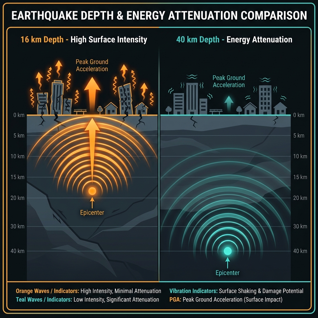
Seismologists classify earthquakes at depths less than 70 kilometers as “shallow crustal” events, but the practical difference between a 16-kilometer rupture and one at 40 kilometers is the difference between a jolt and a jarring. At 16 kilometers, the seismic energy has minimal overburden to absorb its force before hitting surface structures. The resulting ground motion typically produces higher peak accelerations—the violent sideways and vertical movements that damage buildings and trigger landslides on Hawaii’s steep volcanic terrain.
This earthquake arrived as the dramatic climax to a week-long swarm that has produced 27 tremors across the region. Prior to Friday’s mainshock, the largest event was a magnitude 4.6 quake at 34 kilometers depth near Kahaluu-Keauhou, deeper and therefore less intense at the surface than Friday’s shallower, more powerful jolt. The progression from deeper, smaller events to this shallow magnitude 6.0 suggests a migration of stress upward through the crust, though seismologists caution that swarm dynamics remain complex and not fully predictable. The shallow depth also means aftershocks, if they occur at similar depths, will be felt with particular intensity.
| Event | Magnitude | Depth | Distance from Kona | Significance |
|---|---|---|---|---|
| May 23 Mainshock | 6.0 | 16 km | Epicenter | Shallow, intense shaking |
| Swarm Largest (May 16-22) | 4.6 | 34 km | ~10 km | Deeper, less intense |
| 2006 Puako | 6.7 | 14 km | 52 km north | Comparable depth, more energy |
| 2018 Leilani Estates | 6.9 | ~5 km | 86 km southeast | Shallower, larger magnitude |
| 2006 Hawi | 6.0 | 20 km | 80 km north | Similar magnitude, deeper |
What Should Residents Do Right Now?
Residents across the Kona district should immediately inspect structures for fresh cracks in foundations, shifted doorframes, or damaged gas lines, as aftershocks from this shallow event could trigger further damage to compromised buildings. Given the week’s preceding swarm activity, seismologists expect continued seismicity, potentially including strong aftershocks in the magnitude 4-5 range over the coming days. Secure heavy furniture and water heaters that may have shifted during the initial shaking, and maintain emergency supplies for at least 14 days—a standard Hawaii precaution given the island’s isolation. While this earthquake did not generate a tsunami, stay alert for official communications from the Pacific Tsunami Warning Center and be prepared for brief evacuation drills if subsequent larger events occur offshore.
What Happens Next?
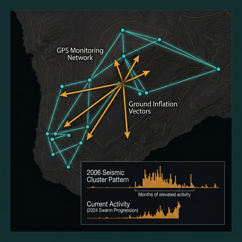
The coming weeks will reveal whether Friday’s magnitude 6.0 represents the climax of this seismic episode or merely the largest pulse in an ongoing volcanic-tectonic conversation. Seismologists will monitor for “inflation”—ground swelling detected by GPS networks that might indicate magma movement beneath Mauna Loa’s southwest rift zone, which lies uncomfortably close to the Kona coast. Historical patterns suggest that shallow earthquakes in this region often cluster; following the 2006 M6.7, the area experienced months of elevated seismicity. For now, GeoShake’s monitoring networks remain vigilant, tracking every tremor to distinguish between ordinary tectonic settling and the geological whisper that might precede something larger.
Frequently Asked Questions
How strong was this earthquake?
A magnitude 6.0 earthquake releases approximately 15 times more energy than the M4.6 that preceded it earlier in the week. Because it struck at only 16 kilometers depth, the shaking intensity at the surface reached levels capable of causing moderate damage to poorly constructed buildings and minor damage to well-built structures across the Kona coast.
Is there a tsunami risk?
No tsunami was generated by this earthquake, according to initial assessments. Tsunamis typically require vertical displacement of the seafloor during submarine earthquakes, and this event occurred beneath land at sufficient depth to limit such oceanic displacement. However, residents should always heed subsequent warnings if larger offshore earthquakes occur.
Why is this area so seismically active?
The Kona coast sits on the western flank of Mauna Loa, where the massive weight of the volcano creates gravitational stress and magma movement generates earthquakes. Unlike California’s plate-boundary faults, Hawaii’s seismicity stems from hotspot volcanism and the slow, catastrophic collapse of volcanic slopes toward the sea.
Track this event live on the map!
Download GeoShake and get instant earthquake alerts.
Download GeoShake