
Ten kilometers beneath the cerulean surface of the Coral Sea, the Earth shifted. At 7:30 PM UTC on May 22, 2026, a magnitude 5.4 earthquake ruptured just 160 kilometers west of Lata, sending shockwaves through the seismically volatile Santa Cruz Islands, according to USGS data. The shallow depth—barely six miles below the seafloor—transformed what might otherwise be a moderate tremor into a more vigorous local shaking event, amplifying the ground motion that residents of these remote Pacific islands experienced.
Why Is This Region So Prone to Powerful Quakes?
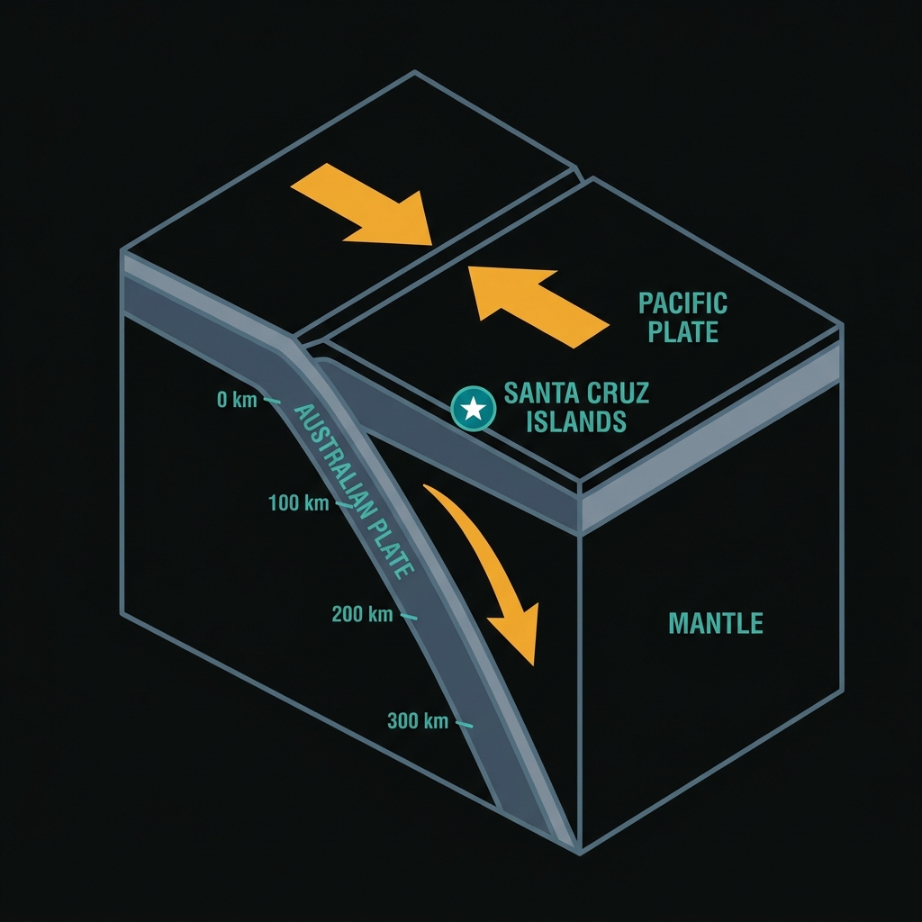
The Santa Cruz Islands sit astride one of the planet’s most active geological boundaries: the convergent margin where the Australian Plate drives beneath the Pacific Plate. This process, known as subduction, creates the seismically charged environment that spawned not only today’s moderate tremor but also the devastating magnitude 8.0 earthquake that struck the same region in February 2013. That earlier event, located just 86 kilometers from today’s epicenter, unleashed a deadly tsunami and killed several people on the island of Nendö, demonstrating the lethal potential of this particular tectonic setting.
Seismologists classify this area as a classic subduction zone, where the oceanic crust of the Australian Plate descends into the mantle beneath the lighter Pacific Plate at a rate of several centimeters per year. The friction between these massive tectonic plates builds stress over decades and centuries, releasing suddenly as earthquakes that can range from barely perceptible tremors to catastrophic megathrust events. The region’s history reads like a catalog of significant seismicity: since 1992 alone, the area has experienced nine earthquakes of magnitude 6.9 or greater within 200 kilometers of today’s epicenter, including multiple magnitude 7.0+ events in 2013, 2015, and 1993. These recurring events punctuate the continuous geological transformation occurring beneath the ocean waves.
What Does Such a Shallow Depth Mean for Local Impact?
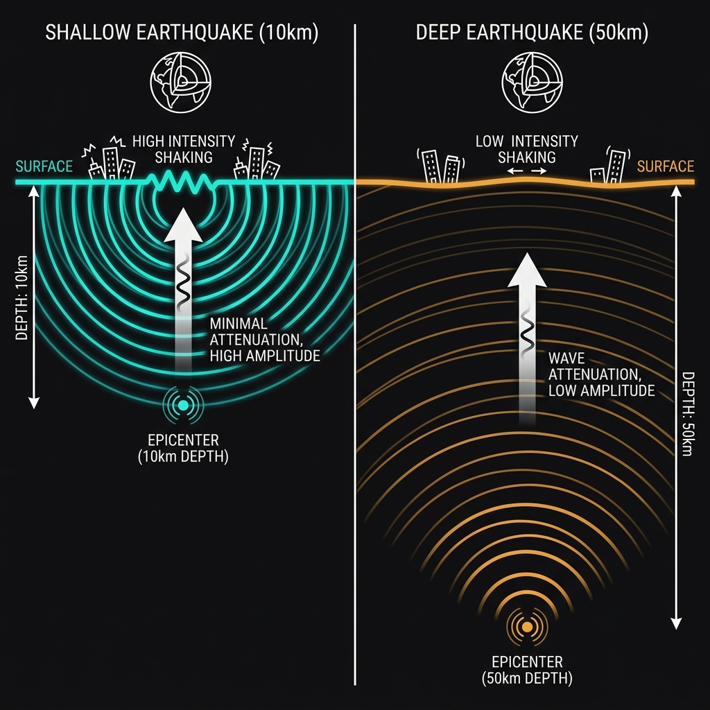
Depth matters profoundly in seismology. Today’s earthquake struck at approximately 10 kilometers depth, placing it in the category of shallow-focus earthquakes that typically produce more intense ground shaking than deeper events of equivalent magnitude. When an earthquake ruptures close to the surface, the seismic energy has less distance to travel before reaching communities, meaning less attenuation of the damaging waves. Seismologists estimate that a magnitude 5.4 event at 10 kilometers depth can produce peak ground accelerations comparable to a magnitude 6.0 event at 50 kilometers depth, though over a more concentrated area near the epicenter.
The following table illustrates how today’s event compares to significant historical earthquakes in the region:
| Event | Year | Magnitude | Depth | Distance from Lata | Notable Impact |
|---|---|---|---|---|---|
| Today’s earthquake | 2026 | M5.4 | 10 km | 160 km W | Localized strong shaking |
| 2013 Santa Cruz Islands | 2013 | M8.0 | ~29 km | 86 km E | Devastating tsunami, deaths |
| 1993 Solomon Islands | 1993 | M7.1 | ~33 km | 178 km W | Significant regional damage |
| 2015 Aftershock | 2015 | M7.0 | ~10 km | 80 km WNW | Strong local effects |
This proximity to the surface explains why residents near the epicenter likely experienced sharp, jarring motions rather than the rolling sway associated with deeper teleseismic events. To put this in perspective, the shaking from a shallow M5.4 resembles the sensation of a large construction blast or heavy industrial machinery operating nearby—distinctly noticeable and potentially alarming, capable of knocking items from shelves or cracking vulnerable masonry. However, the moderate magnitude limits the rupture area and total energy release, preventing the widespread devastation seen in the 2013 magnitude 8.0 event, which released roughly 15,000 times more energy and ruptured a much larger segment of the plate boundary.
What Happens Next?
While today’s earthquake does not appear to have triggered a tsunami—authorities issued no warning for this moderate, shallow event—seismologists will closely monitor the region for aftershocks over the coming days and weeks. The Santa Cruz Islands subduction zone remains loaded with tectonic stress, and moderate earthquakes like this one sometimes serve as foreshocks to larger events, though such sequences are statistically uncommon. More likely, this represents the continued, gradual release of accumulated strain along the complex plate boundary, where the Earth occasionally readjusts itself in increments ranging from the barely perceptible to the catastrophic.
Frequently Asked Questions
How strong was this earthquake?
The earthquake registered as magnitude 5.4 on the moment magnitude scale, striking at a shallow depth of just 10 kilometers. While not considered a major earthquake, the shallow depth meant that shaking intensity near the epicenter was significantly amplified compared to a deeper event of the same magnitude.
Is there a tsunami risk from this event?
No tsunami warning was issued for this earthquake. Tsunamis typically require larger magnitude events (usually M7.0 or greater) with significant vertical displacement of the seafloor, particularly in subduction zones. However, the region has a history of tsunami generation, most notably from the 2013 M8.0 Santa Cruz Islands earthquake.
Why is this area so seismically active?
The Santa Cruz Islands lie within a subduction zone where the Australian Plate dives beneath the Pacific Plate. This tectonic collision generates frequent earthquakes as stress builds and releases along the plate interface and within the descending slab, making the region one of the most earthquake-prone areas in the Southwest Pacific.
Track this event live on the map!
Download GeoShake and get instant earthquake alerts.
Download GeoShake