
The ground lurched barely ten kilometers beneath the surface—shallow enough that the seismic energy had scarcely begun to dissipate before it slammed into the city above. On May 18, 2026, at 1:44 PM UTC, a magnitude 5.1 earthquake ruptured just 26 kilometers northwest of Liuzhou, a sprawling industrial metropolis in southern China’s Guangxi Zhuang Autonomous Region, according to USGS data. At that depth, roughly six miles down, the quake behaved less like a distant rumble and more like a hammer striking a bell, sending sharp, high-frequency vibrations directly into the foundations of buildings and industrial facilities across the region.
Why Is This Region So Seismically Active?
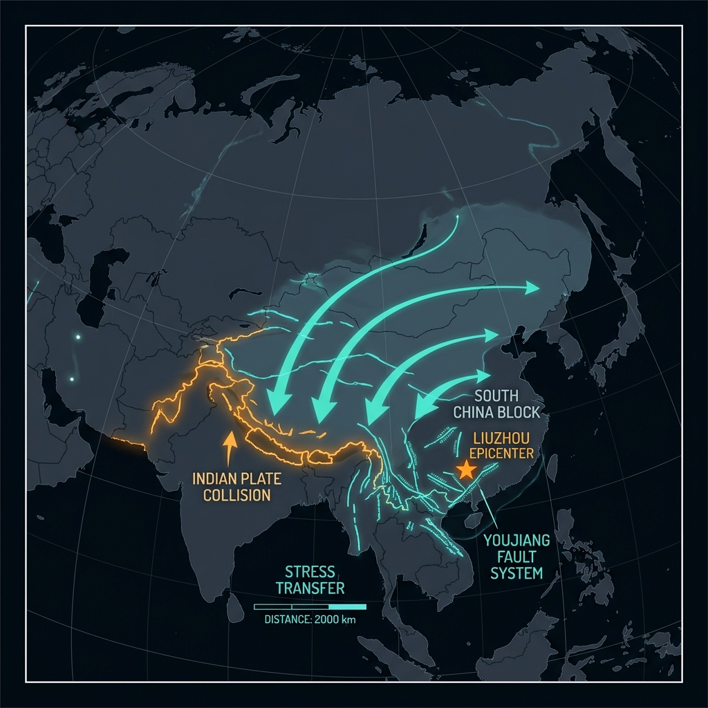
Liuzhou sits within the South China Block, a tectonic plate fragment that most assume is geologically quiet compared to the collision zones of the Himalayas or the volatile faults of the Pacific Rim. Yet this stability is deceptive. The relentless northward march of the Indian Plate into Eurasia, ongoing for millions of years, transmits stresses thousands of kilometers eastward into the heart of the continent. These distant forces reactivate ancient weaknesses in the crust—buried fault lines that date back hundreds of millions of years to when these landmasses were assembled during the Proterozoic era.
The region around Liuzhou is crisscrossed by a network of hidden fractures, including segments of the Youjiang Fault system and other intraplate structures that occasionally slip without warning. Unlike the dramatic subduction zones that generate the world’s largest tremors, these interior earthquakes are unpredictable and relatively rare, making them difficult to forecast. When they do occur, they expose the vulnerability of densely populated areas unaccustomed to frequent shaking. Liuzhou itself serves as a critical manufacturing hub, hosting major automotive plants and heavy industry facilities that are particularly sensitive to ground motion.
What Does Such a Shallow Depth Mean?
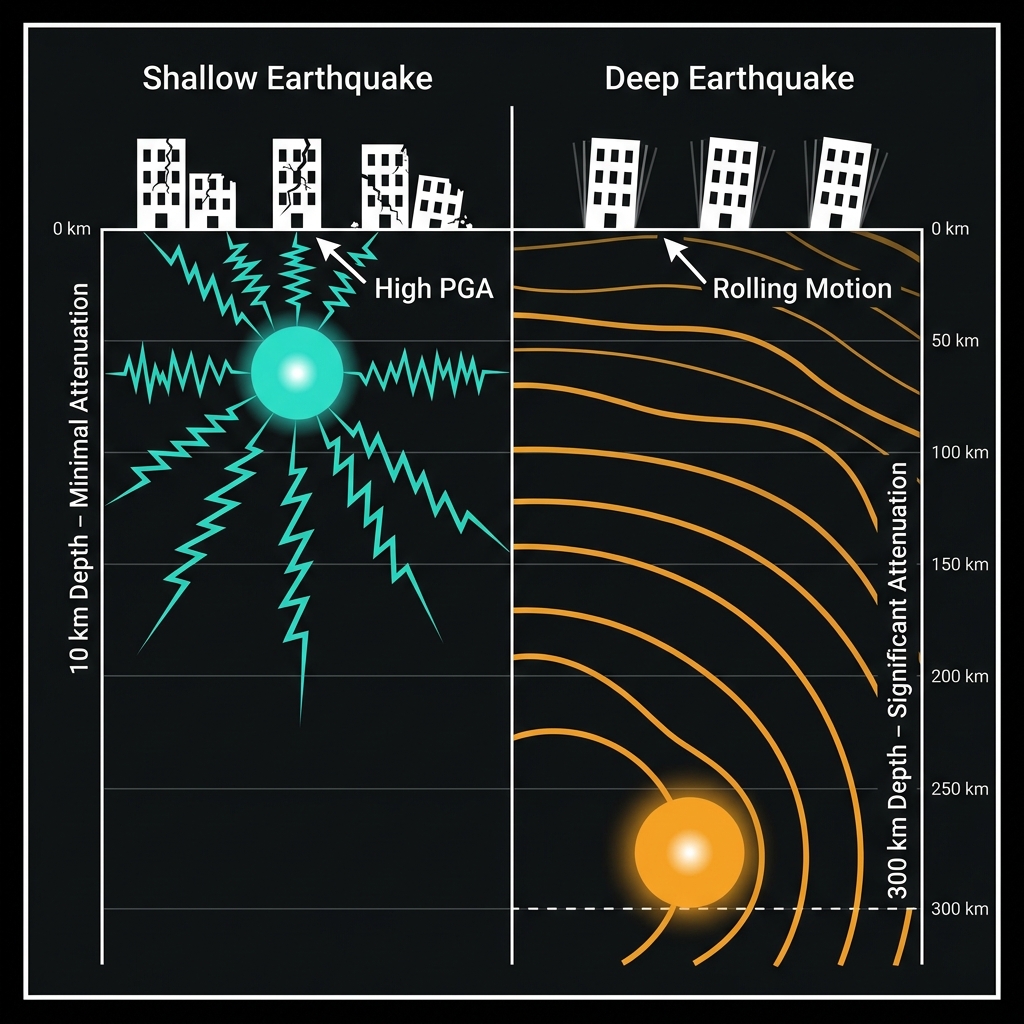
Depth determines destiny in seismology. Seismologists classify earthquakes into three depth categories: shallow (0-70 km), intermediate (70-300 km), and deep (300-700 km). This event falls squarely in the shallow category, where the rupture sits close enough to the surface that seismic waves arrive with minimal attenuation—the technical term for the weakening of energy as it travels through rock.
To understand the practical difference, consider that a magnitude 5.1 earthquake at 300 kilometers depth might produce gentle swaying felt across several provinces, akin to the motion of a tall building in the wind. The same magnitude at 10 kilometers depth delivers a sharp jolt capable of knocking unsecured items from shelves and cracking masonry. The proximity to the surface concentrates the energy release into a smaller geographic footprint, but intensifies the violence within that zone. For the approximately four million residents of Liuzhou, this meant experiencing the full brunt of the rupture with little geological cushioning.
The following comparison illustrates how depth alters an earthquake’s character:
| Characteristic | This Event (10 km depth) | Deep Equivalent (300 km) |
|---|---|---|
| Energy dissipation | Minimal before surface | Significant attenuation |
| Felt intensity near epicenter | Strong to very strong (MMI VI-VII) | Light to moderate (MMI III-IV) |
| Duration of shaking | Short, sharp pulses | Longer, rolling waves |
| Affected radius | Tens of kilometers | Hundreds of kilometers |
Seismologists classify this as a shallow crustal earthquake, the type most likely to cause structural damage due to the high peak ground accelerations it generates. The magnitude 5.1 figure represents the total energy released, but the Modified Mercalli Intensity—the scale that measures actual effects on people and buildings—likely reached VI to VII near the epicenter, indicating potential damage to poorly constructed structures and alarm among the general population. The region’s karst topography, characterized by soluble limestone bedrock riddled with caves and sinkholes, may have further complicated the shaking by amplifying certain frequencies of seismic waves through site effects. Modern high-rise buildings in Liuzhou’s downtown likely weathered the event with minimal damage, while older unreinforced masonry structures in surrounding rural communities may have suffered cracked walls or dislodged roof tiles.
What Should We Watch For Next?
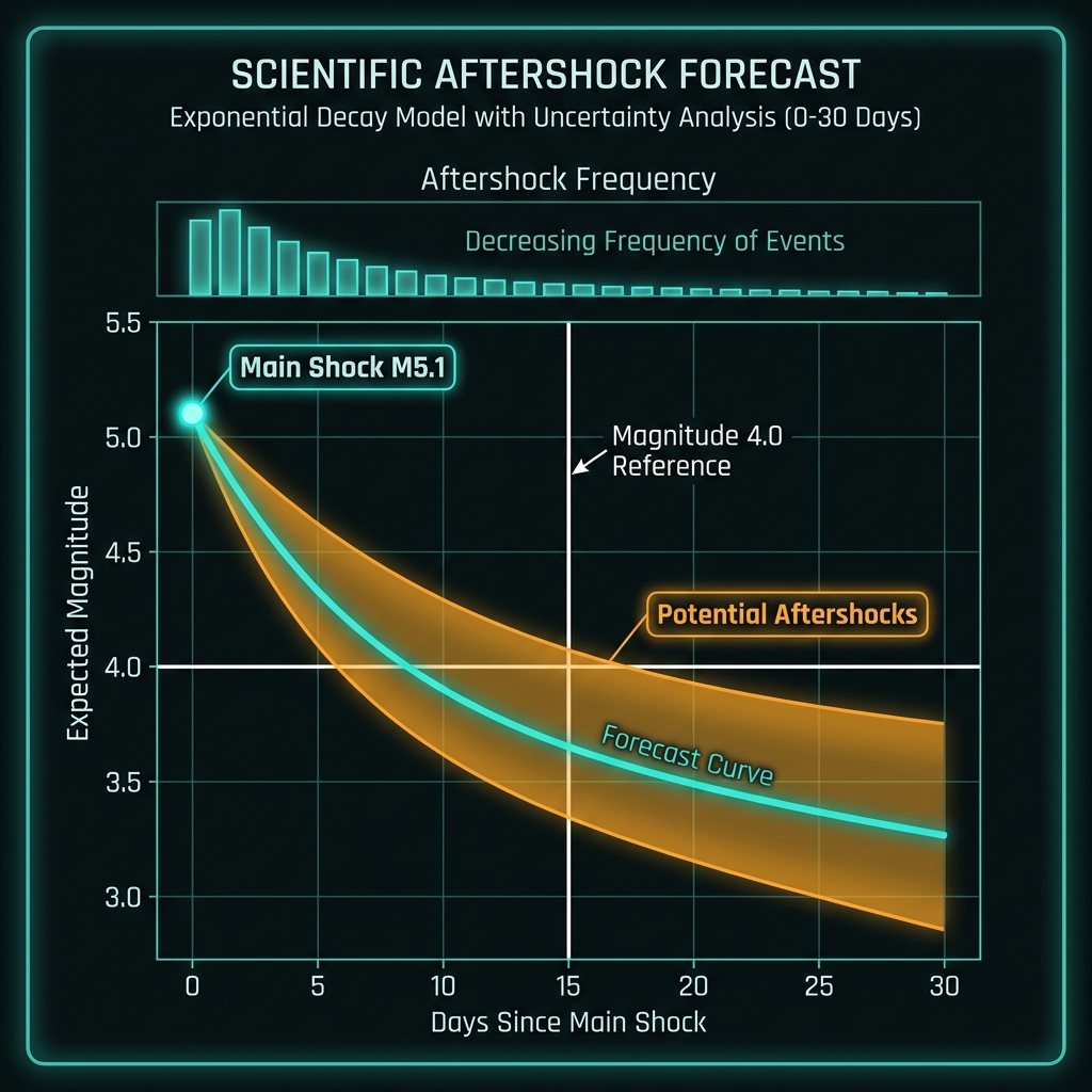
In the coming days, seismologists will monitor for aftershocks—smaller earthquakes that follow the main shock as the crust adjusts to its new stress state. While a magnitude 5.1 event rarely triggers a devastating sequence, residents should expect tremors up to magnitude 4.0 in the vicinity, potentially continuing for weeks. Engineers will survey the city’s bridges and factory infrastructure, particularly given Liuzhou’s role as a manufacturing hub for automobiles and machinery, where even minor ground motion can disrupt precision assembly lines. GeoShake will continue tracking regional seismicity, watching for any signs that this event has increased stress on adjacent fault segments. Fortunately, the inland location eliminates tsunami risk entirely, and the relatively moderate magnitude suggests catastrophic structural failure is unlikely in modern buildings designed to Chinese seismic codes.
Frequently Asked Questions
How strong was this earthquake?
The earthquake registered magnitude 5.1 on the moment magnitude scale, a measurement of the total energy released during the rupture. Because it occurred at a shallow depth of only 10 kilometers, the shaking felt at the surface was significantly more intense than the magnitude number alone might suggest, likely producing strong to very strong perceptible motion near the epicenter capable of alarming residents and causing minor damage to vulnerable structures.
Is there a tsunami risk from this earthquake?
No tsunami risk exists from this event. Liuzhou sits approximately 300 kilometers inland from the coast of the South China Sea, and tsunamis require oceanic displacement—typically triggered by underwater earthquakes, landslides, or volcanic activity—to form. Even if the quake had occurred on the coast, its moderate magnitude and inland location make a tsunami impossible.
Why is this area seismically active despite being far from plate boundaries?
The region experiences intraplate earthquakes caused by stress transferred from distant tectonic collisions, primarily the ongoing convergence of the Indian and Eurasian plates over 2,000 kilometers to the west. These forces reactivate ancient, deeply buried faults within the stable interior of the South China Block, creating occasional but potentially damaging earthquakes in areas that lie far from the planet’s major tectonic boundaries.
Track this event live on the map!
Download GeoShake and get instant earthquake alerts.
Download GeoShake