
The ground shook with unusual ferocity for an offshore event. At 10:08 UTC on May 22, 2026, a magnitude 5.7 earthquake ruptured just 10 kilometers beneath the seafloor—shallow enough to transform distant tectonic stress into violent local shaking—approximately 103 kilometers southeast of Lorengau, Papua New Guinea, according to USGS data. While the epicenter sat offshore, that precarious depth means seismic waves had minimal time to dissipate before striking coastal communities, amplifying the hazard well beyond what the magnitude number alone suggests.
Why Is This Region So Seismically Volatile?
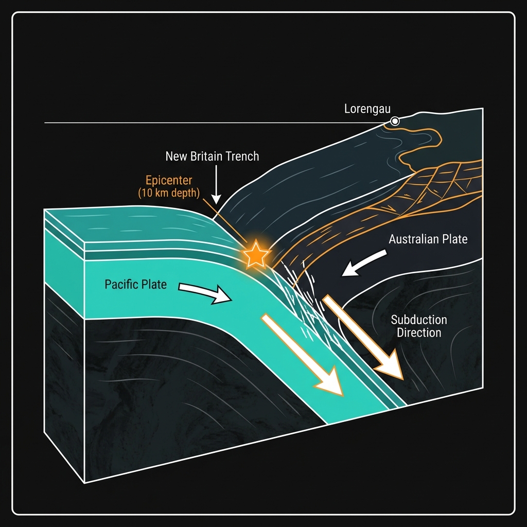
The seafloor southeast of Lorengau sits at the collision point of massive tectonic plates. Here, the Pacific Plate plunges beneath the Australian Plate along the New Britain Trench, creating a subduction zone that generates frequent seismic strain. This tectonic compression has produced a remarkable pattern of powerful earthquakes over the past four decades.
Historical records reveal at least ten magnitude 6.0 or greater events within 200 kilometers of today’s epicenter since 1987. These include a magnitude 6.4 in 1992 located just 25 kilometers from this recent rupture, and another magnitude 6.4 in 2016 only 38 kilometers away. Such clustering suggests the region operates on a persistent cycle of stress accumulation and release, making today’s event less an anomaly than a continuation of established geologic behavior.
| Year | Magnitude | Distance from Lorengau | Notes |
|---|---|---|---|
| 2026 | 5.7 | 103 km | Today’s event (10 km depth) |
| 2025 | 6.3 | 139 km | Recent significant event |
| 2016 | 6.4 | 133 km | Shallow crustal event |
| 2005 | 6.4 | 156 km | Deep intraslab event |
| 1992 | 6.4 | 127 km | Proximal to current epicenter |
| 1987 | 6.3 | 189 km | Early record in sequence |
What Does Ten Kilometers Mean for Ground Shaking?
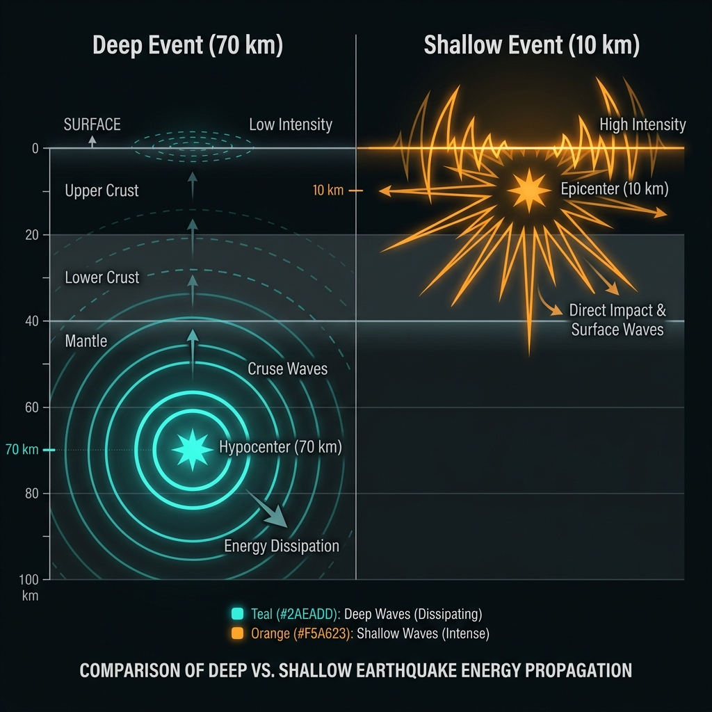
Depth determines destruction. Seismologists classify earthquakes at 10 kilometers as exceptionally shallow, meaning rupture occurs within the brittle crust rather than the ductile mantle below. When faults break this close to the surface, seismic energy strikes communities with minimal attenuation, often producing shaking intensities typically associated with much larger, deeper events.
To understand the difference, consider dropping a stone into a pond versus slapping the water’s surface. Deep earthquakes, like the sinking stone, send ripples that spread and weaken before reaching shore. Shallow events like today’s magnitude 5.7 act like that surface slap—immediate, intense, and locally concentrated. Residents likely experienced Modified Mercalli Intensity VI to VII shaking, strong enough to crack plaster, dislodge unsecured objects, and disturb standing vehicles.
What Should Residents Do Now?
Even without an official tsunami warning, coastal communities should treat offshore shallow earthquakes with immediate caution. Move to higher ground or inland for at least two hours following the shaking, as shallow submarine events can occasionally trigger localized surges not detected by deep-ocean buoy systems. Inspect homes for new structural cracks, especially in unreinforced masonry, and secure top-heavy furniture against potential aftershocks. Check on vulnerable neighbors and verify that emergency water supplies and communication devices remain accessible, as aftershocks above magnitude 4.0 could continue for days.
What Happens Next?
Monitoring networks will now watch for aftershocks or potential foreshock sequences. The proximity of this event to historical magnitude 6.4 ruptures raises questions about whether today’s earthquake relieved local stress or transferred it to adjacent locked segments of the fault. Geoscientists will analyze the rupture mechanism to determine if this represents shallow thrust faulting along the subduction interface or intraplate deformation within the overriding plate. Communities should remain alert for 24-48 hours, as the region’s history suggests subsequent events could approach magnitude 6.0 if stress redistribution triggers adjacent fault sections.
Frequently Asked Questions
How strong was this earthquake compared to recent local activity?
Today’s magnitude 5.7 event surpasses the magnitude 4.8 tremor recorded just seven days ago approximately 116 kilometers southeast of Lorengau. While significantly smaller than the magnitude 6.3 and 6.4 earthquakes that have struck this region in 2025, 2016, and 2005, its extremely shallow depth means surface shaking was likely more intense than those deeper, larger historical events. The ground acceleration near the epicenter probably reached levels capable of causing minor structural damage despite the moderate magnitude.
Is there a tsunami risk from this event?
No tsunami warning has been issued for this earthquake according to available data. However, shallow offshore earthquakes of this magnitude warrant brief precautionary measures, as localized seiches or minor sea level disturbances can occasionally occur near the epicenter without triggering Pacific-wide alert systems. Residents should observe the ocean for unusual withdrawals or surges for two hours following the event and avoid low-lying coastal areas during this window.
Why does Papua New Guinea experience so many earthquakes?
Papua New Guinea sits at the complex boundary between the Pacific and Australian tectonic plates, specifically along the New Britain Trench where dense oceanic crust subducts beneath continental crust. This continuous collision generates immense friction and stress, releasing periodically as earthquakes ranging from moderate tremors to catastrophic magnitude 8.0+ events. The region’s position on the Ring of Fire ensures constant seismic activity, with the area near Lorengau experiencing at least ten magnitude 6.0 or greater earthquakes in the past four decades alone.
Track this event live on the map!
Download GeoShake and get instant earthquake alerts.
Download GeoShake