
At 4:26 AM local time, the Taurus Mountains shuddered from a rupture just 9.3 kilometers beneath the surface—shallower than the cruising altitude of a skydiving plane. The magnitude 4.9 tremor struck near the district of Saimbeyli in Turkey’s Adana Province, according to USGS data, delivering a sharp reminder that the region’s geological restlessness extends far beyond the well-known faults of the east. For the residents jolted awake in the predawn darkness, the quake’s shallow origin meant the seismic energy arrived with unsettling immediacy, transforming a moderate magnitude into tangible, rattling force.
Why Is This Corner of Turkey So Prone to Shaking?
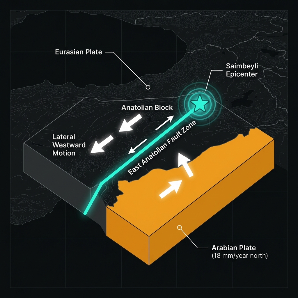
Saimbeyli sits at the northern edge of the Arabian Plate’s relentless collision with Eurasia, a geologic traffic jam that has sculpted the Anatolian Peninsula over millions of years. Here, the East Anatolian Fault Zone—a major strike-slip boundary where two massive blocks slide horizontally past one another like grinding gears—splinters into a complex network of splay faults and thrust sheets beneath the Taurus Mountains. Seismologists classify this region as a broad transition zone between the dominantly strike-slip tectonics of eastern Turkey and the compressional forces of the Cyprus Arc to the south.
The Arabian Plate pushes northward at roughly 18 millimeters per year, forcing the Anatolian Block westward and creating a web of shallow crustal faults capable of producing sudden, energetic releases of stress. Unlike subduction zones where one plate dives beneath another, these shallow faults generate earthquakes that are felt intensely over smaller areas because the seismic waves dissipate less energy before reaching the surface.
What Does 9.3 Kilometers Mean for the Shaking?
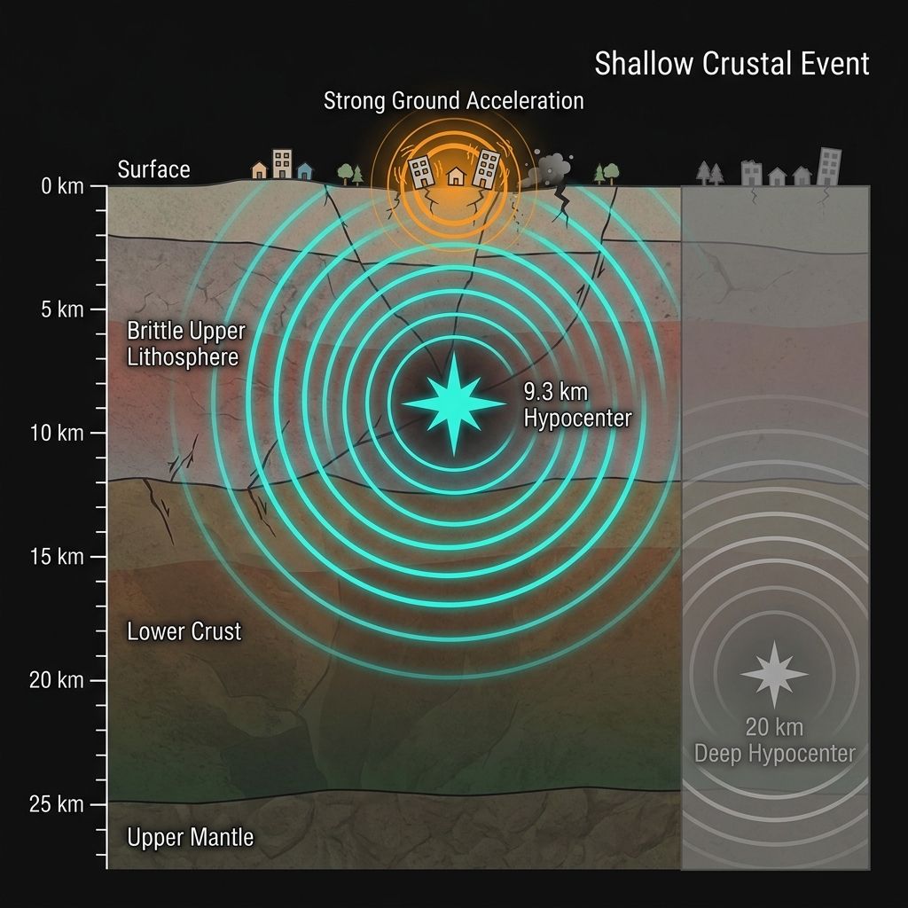
Depth is the hidden variable that transforms a moderate magnitude into a disruptive experience. At 9.32 kilometers, this event qualifies as a shallow-focus or crustal earthquake, occurring entirely within the brittle upper layer of the Earth’s lithosphere where rocks fracture abruptly. Seismologists note that earthquakes at this depth typically produce stronger ground acceleration at the surface than deeper events of equivalent magnitude because the seismic waves travel a shorter distance through the absorbing upper mantle.
For perspective, the energy released here, while significant, pales in comparison to Turkey’s recent catastrophic events. The following table illustrates how depth and magnitude interact to create different hazard profiles across the region:
| Event | Location | Magnitude | Depth (km) | Impact |
|---|---|---|---|---|
| May 24, 2026 | Saimbeyli, Adana | 4.9 MW | 9.3 | Localized strong shaking, minor damage |
| Feb 6, 2023 | Pazarcık, Kahramanmaraş | 7.8 MW | 17.9 | Widespread devastation, thousands of structures collapsed |
| Jan 24, 2020 | Sivrice, Elazığ | 6.7 MW | 11.0 | Significant damage, hundreds of buildings destroyed |
| Oct 30, 2020 | Aegean Sea | 7.0 MW | 21.0 | Tsunami generation, coastal building collapse |
The Saimbeyli tremor likely produced Modified Mercalli Intensity values of V to VI—strong enough to rattle dishes, disturb sleep, and cause minor damage in vulnerable masonry structures, but generally not catastrophic. Residents in Adana city, roughly 100 kilometers to the south, may have felt the vibration as a gentle swaying, while those directly above the epicenter experienced sharper, more abrupt jolts typical of shallow ruptures.
What Should We Expect in the Coming Days?
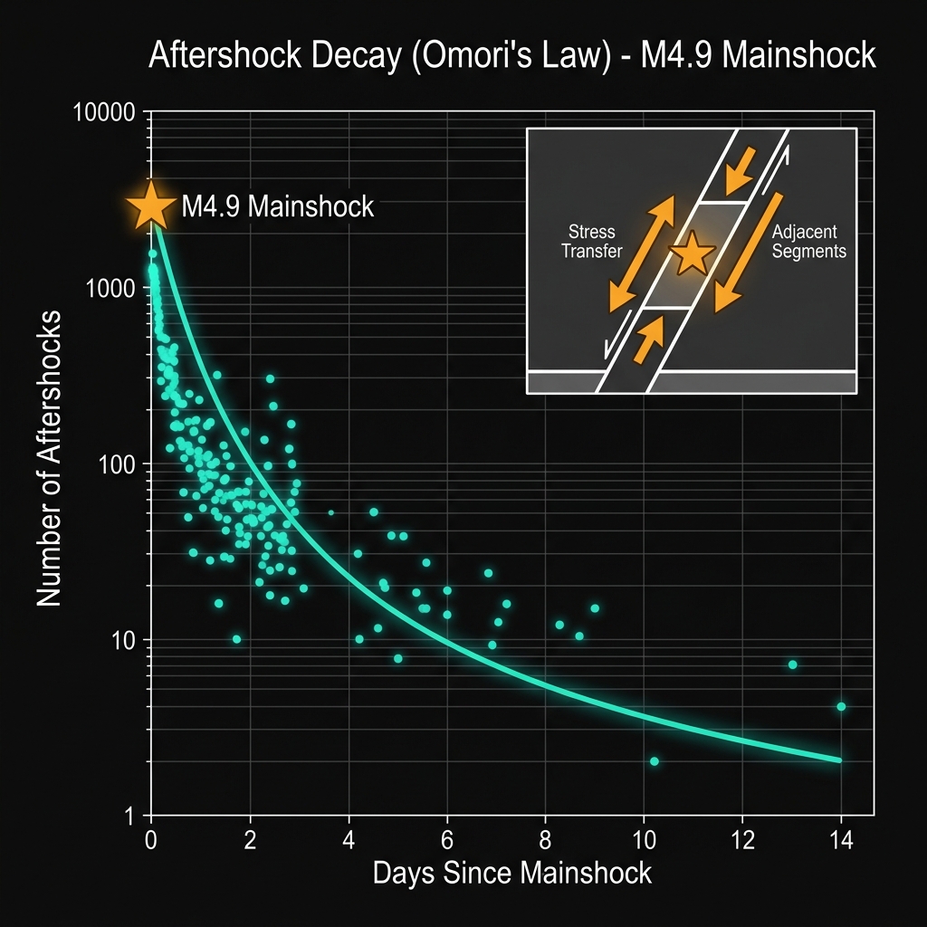
When the crust ruptures at such shallow depths, the surrounding fault blocks undergo a rapid redistribution of stress that often triggers smaller aftershocks as the rock mass settles into a new equilibrium. Seismologists monitoring the region will be watching for a decay sequence—smaller tremors that decrease in frequency over days to weeks following the mainshock. While a magnitude 4.9 event does not typically presage a larger rupture on the same fault segment, it serves as a subtle stress-transfer signal to adjacent sections of the East Anatolian Fault.
GeoShake’s monitoring networks will continue to track microseismicity in the Taurus foothills, looking for any anomalous clustering that might indicate evolving strain. For now, the immediate risk remains limited to localized aftershocks and potential rockfall in the steep terrain surrounding Saimbeyli, where fractured limestone and loose scree can dislodge during subsequent vibrations.
Frequently Asked Questions
How strong was this earthquake?
A magnitude 4.9 earthquake releases roughly 30 times less energy than a magnitude 6.0 event and about 1,000 times less than the magnitude 7.8 Kahramanmaraş earthquake of 2023. While classified as “light” on the Richter scale, its shallow depth of 9.3 kilometers meant the shaking felt at the surface was stronger than the number alone suggests, likely causing rattling objects and minor damage near the epicenter.
Is there a risk of a tsunami from this event?
No. This earthquake occurred inland, approximately 100 kilometers from the Mediterranean coast, and at a depth and magnitude insufficient to displace the seafloor. Tsunamis require significant vertical movement of the ocean floor, typically from underwater earthquakes larger than magnitude 7.0 or major submarine landslides, neither of which apply here.
Why is the Saimbeyli area so seismically active?
The region sits near the East Anatolian Fault Zone, a major boundary where the Anatolian and Arabian plates grind past each other. This tectonic collision creates a complex network of shallow faults in the Taurus Mountains, making the area susceptible to frequent moderate earthquakes as the crust accommodates the northward push of the Arabian Plate.
Track this event live on the map!
Download GeoShake and get instant earthquake alerts.
Download GeoShake