
The ground beneath Myanmar’s commercial hub stirred awake on the morning of May 18, 2026, as a shallow magnitude 5.2 earthquake rippled through the Irrawaddy Delta. Striking at 08:35 local time just 36 kilometers southeast of Syriam—across the river from Yangon—the tremor originated at a depth of only 10 kilometers, according to USGS data. Such shallow events often translate to sharper shaking at the surface, and residents across the metropolitan area likely felt the earth’s brief but unmistakable lurch.
Why Is This Region So Seismically Active?
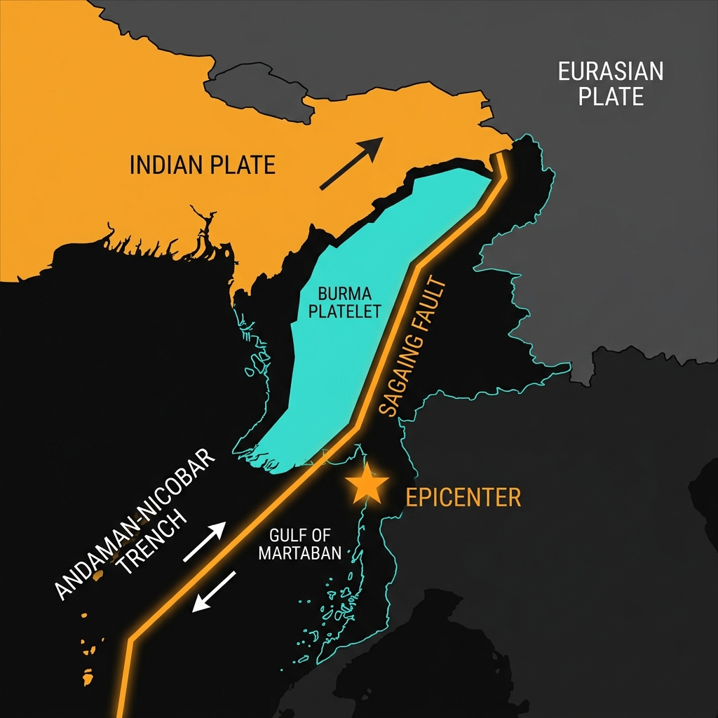
Myanmar occupies one of the most tectonically crowded real estate parcels on Earth. The country sits astride the Burma Platelet, a sliver of crust caught between the lumbering northward advance of the Indian Plate and the stable mass of the Eurasian Plate. To the west, the Indian Plate dives beneath the Bay of Bengal along the Andaman-Nicobar subduction zone, while the 1,200-kilometer Sagaing Fault slices through the country’s spine like a suture line.
This morning’s epicenter lies within the complex fault systems of the Gulf of Martaban region, where minor crustal blocks adjust to the broader collision. Historical records remind us this is familiar territory for seismic unrest. In 1991, a magnitude 6.0 event struck 60 kilometers south of Pyapon—roughly 100 kilometers from today’s epicenter—while 1995 saw a magnitude 6.1 quake shake the Bago Region to the north. These events punctuate a longer narrative of stress accumulation and release that has shaped the landscape for millennia.
What Does This Depth Mean for Shaking?
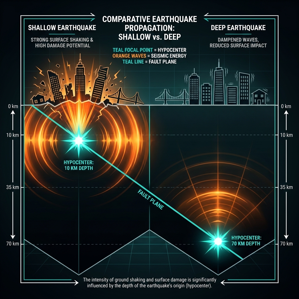
At ten kilometers deep, this earthquake qualifies as a shallow crustal event. Seismologists classify earthquakes with focal depths less than 70 kilometers as shallow, but those occurring in the uppermost ten kilometers carry particular significance for human populations. The energy released has less rock to dampen its transmission, often resulting in more intense ground motion than a deeper quake of equivalent magnitude.
For perspective, a magnitude 5.2 event releases roughly the energy equivalent of 1,000 tons of TNT—comparable to a small industrial explosion, though distributed across a fault plane rather than a single point. In urban areas like Yangon, with its mix of modern high-rises and older masonry structures, such shaking might send swaying light fixtures and rattling windows. The USGS estimates that earthquakes of this magnitude can be felt up to 100 kilometers from the epicenter under favorable conditions, suggesting the tremor likely reached across the delta and into the city proper.
| Event | Year | Magnitude | Distance from Yangon | Significance |
|---|---|---|---|---|
| SSE of Syriam | 2026 | 5.2 | 36 km | Shallow, widely felt |
| S of Pyapon | 1991 | 6.0 | ~99 km | Delta region |
| WSW of Nyaunglebin | 1995 | 6.1 | ~163 km | Bago Region |
What Should We Watch For?
Single moderate earthquakes rarely occur in complete isolation. Seismologists will be watching closely for aftershocks—smaller tremors that follow the mainshock as the crust adjusts to new stress patterns. While these typically decrease in both frequency and magnitude over days or weeks, the region’s residents should remain aware that additional jolts are possible.
This event serves as another reminder that the Sagaing Fault system and its surrounding structures remain under significant tectonic stress. The 2026 tremor does not necessarily presage a larger disaster, but it underscores the continuous deformation occurring beneath Myanmar. For GeoShake monitors, this event adds another data point to the long-term catalog of Burmese seismicity, helping refine models of where future stress might break the surface.
Frequently Asked Questions
How strong was this earthquake?
A magnitude 5.2 earthquake is considered moderate. It is powerful enough to be felt widely across the region and may cause minor damage to poorly constructed buildings near the epicenter, but it is approximately 63 times weaker than a magnitude 7.0 event. The shallow depth of 10 kilometers likely amplified the shaking experienced at the surface.
Is there a tsunami risk?
No tsunami warning was issued for this event. According to USGS data, the earthquake occurred inland with a magnitude below the typical threshold required to generate significant ocean displacement. Tsunamis generally require underwater earthquakes of magnitude 7.0 or greater, particularly those involving vertical movement of the seafloor along subduction zones.
Why is this area so seismically active?
Myanmar sits at the collision boundary between the Indian and Eurasian tectonic plates. The country lies on the Burma Platelet, which is being squeezed between the westward-subducting Indian Plate and the stable Eurasian continent. Major structures like the Sagaing Fault and the Andaman subduction zone create a complex network of seismic hazards, making earthquakes a regular feature of the region’s geological landscape.
Track this event live on the map!
Download GeoShake and get instant earthquake alerts.
Download GeoShake