Volcanic activity remained elevated across the Pacific Ring of Fire on May 30, 2026, with the Smithsonian Global Volcanism Program documenting 26 distinct eruptive events spanning 14 active volcanic systems. The most significant hazards emerged from high-altitude ash emissions at Shiveluch on Russia’s Kamchatka Peninsula and Popocatépetl in central Mexico, with volcanic plumes reported at 8,200 meters and 6,400 meters respectively. Additional ash advisories were issued for Indonesia’s Marapi, while confirmed eruptions occurred at Ibu and Fuego, according to data reported by the Smithsonian Global Volcanism Program and local monitoring agencies.
Which Volcanoes Generated the Highest Aviation Hazards Today?
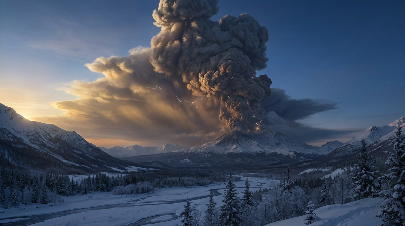
Shiveluch on the Kamchatka Peninsula generated the most significant ash column of the reporting period, with emissions reaching 8,200 meters (26,900 feet) above sea level according to the Tokyo Volcanic Ash Advisory Center. This stratovolcano, one of Kamchatka’s largest and most active, produced sustained ash clouds capable of impacting trans-Pacific flight corridors. The high-altitude plume poses substantial risk to commercial aviation, as these altitudes intersect with standard cruising levels for long-distance flights between North America and Asia.
Popocatépetl, located approximately 70 kilometers southeast of Mexico City, issued ash advisories with plume heights reaching 6,400 meters (21,000 feet) reported by USGS and local CENAPRED monitoring networks. The volcano maintained continuous emissions, presenting ongoing hazards for aviation operations in central Mexican airspace. Authorities continue to monitor the 5,426-meter stratovolcano for signs of escalating explosive activity, though no immediate population centers reported significant ashfall during the 24-hour period.
Marapi on Sumatra Island, Indonesia, produced ash emissions reaching 4,900 meters (16,100 feet) according to reports from the Indonesian Center for Volcanology and Geological Hazard Mitigation (PVMBG). While lower than the Kamchatkan and Mexican events, this altitude remains critical for regional aviation routes traversing the Malay Archipelago. Marapi’s frequent phreatic explosions continue to challenge local monitoring efforts due to its sudden eruption style.
Ibu volcano on Halmahera Island, Indonesia, confirmed active eruptive behavior though specific ash column heights were not quantified in available reports. The remote stratovolcano has demonstrated persistent lava dome growth and explosive activity throughout 2026, necessitating continued vigilance from regional VAACs.
How Do These Ash Plume Altitudes Affect Flight Safety?
Commercial aircraft typically operate at cruising altitudes between 9,000 and 12,000 meters (30,000 to 40,000 feet), making any volcanic ash exceeding 6,000 meters a potential hazard for en-route traffic. Shiveluch’s 8,200-meter plume extends well into these flight levels, requiring immediate rerouting of trans-Pacific flights to avoid engine-damaging particulate matter. Volcanic ash consists of abrasive silicate particles that can melt inside jet turbines, causing engine flameout and catastrophic power loss.
The varying altitudes reported—ranging from Marapi’s 4,900 meters to Shiveluch’s 8,200 meters—create complex three-dimensional hazards for air traffic management. Lower plumes primarily affect takeoff and landing corridors near airports, while higher emissions like those from Popocatépetl threaten cruising aircraft hundreds of kilometers downwind. The Washington VAAC and Tokyo VAAC coordinate advisories to ensure pilots receive real-time data on ash dispersion patterns, though visibility reduction and airframe abrasion remain persistent threats even with modern detection systems.
What Other Volcanic Systems Showed Activity?
Beyond the primary ash advisories, the Fuego volcano in Guatemala confirmed eruptive activity with lava flows and minor ash emissions, according to the Smithsonian Global Volcanism Program compilation of local INSIVUMEH reports. The Mayon volcano in the Philippines, Dukono and Semeru in Indonesia, Reventador in Ecuador, Sabancaya in Peru, Sakurajima in Japan, Canlaon in the Philippines, Puracé in Colombia, and Aoba in Vanuatu all registered detectable thermal anomalies, seismic swarms, or minor degassing events during the reporting period. While these systems did not generate high-altitude ash advisories requiring immediate aviation action, they remain under close observation by regional monitoring networks.
| Volcano | Location | Event Type | Alert Level |
|---|---|---|---|
| Shiveluch | Kamchatka Peninsula, Russia | Ash Advisory (8,200m) | Not specified in daily reports |
| Popocatépetl | Mexico | Ash Advisory (6,400m) | Not specified in daily reports |
| Marapi | Indonesia | Ash Advisory (4,900m) | Not specified in daily reports |
| Ibu | Halmahera Island, Indonesia | Eruption | Not specified in daily reports |
| Fuego | Guatemala | Eruption | Not specified in daily reports |
| Mayon | Philippines | Seismic/Thermal Activity | Not specified in daily reports |
| Dukono | Indonesia | Continuous Activity | Not specified in daily reports |
| Reventador | Ecuador | Seismic Activity | Not specified in daily reports |
| Sabancaya | Peru | Degassing/Seismicity | Not specified in daily reports |
| Semeru | Indonesia | Eruptive Activity | Not specified in daily reports |
| Sakurajima | Japan | Minor Explosions | Not specified in daily reports |
| Canlaon | Philippines | Background Activity | Not specified in daily reports |
| Puracé | Colombia | Seismic Swarms | Not specified in daily reports |
| Aoba | Vanuatu | Thermal Anomaly | Not specified in daily reports |
Frequently Asked Questions
What is a volcanic ash advisory and why is it critical for aviation?
A volcanic ash advisory is an official warning issued by one of nine global Volcanic Ash Advisory Centers (VAACs) when volcanic ash reaches altitudes that threaten aircraft operations. These advisories specify the height, concentration, and predicted movement of ash clouds, enabling pilots and air traffic controllers to reroute flights safely. Volcanic ash can cause jet engine failure, abrade cockpit windows, and damage flight control systems, making these warnings essential for preventing in-flight emergencies.
Why does the altitude of volcanic ash matter for flight safety?
The altitude of volcanic ash determines which aircraft are at risk, as commercial jets cruise at 9,000–12,000 meters while regional aircraft operate below 6,000 meters. Ash plumes reaching 8,000 meters or higher, like those from Shiveluch, pose threats to long-haul international flights, while lower emissions affect approach and departure paths near airports. Ash particles can remain suspended in the atmosphere for days and travel thousands of kilometers from the source volcano, creating hazards far beyond the immediate eruption site.
Where can the public find authoritative volcanic activity updates?
Authoritative information is available through the Smithsonian Global Volcanism Program for global activity summaries, national geological surveys such as USGS or local agencies including Indonesia’s PVMBG and Mexico’s CENAPRED for region-specific alerts, and the nine regional VAACs for aviation-specific hazards. These sources provide real-time data on eruption columns, ashfall forecasts, and evacuation recommendations based on ground-based monitoring networks and satellite observations.
Track this event live on the map!
Download GeoShake and get instant earthquake alerts.
Download GeoShake