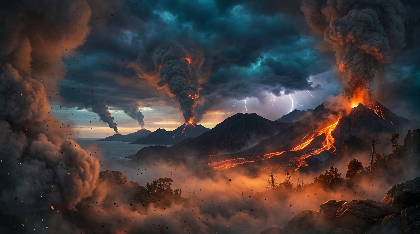
Volcanic unrest persists across the Pacific Ring of Fire and Central America, with monitoring agencies recording 25 distinct volcanic events during the past 24 hours according to the Smithsonian Global Volcanism Program. Today’s activity features significant ash advisories stretching from the Andes to Southeast Asia, with Peru’s Sabancaya volcano generating the most substantial plume at 6,700 meters above sea level. Authorities in Mexico and Indonesia have also issued warnings for elevated emissions that threaten both local populations and transcontinental aviation corridors.
Which Volcanoes Showed Significant Activity Today?
Four volcanoes generated specific ash advisories capable of disrupting regional air traffic and impacting ground communities. Peru’s Sabancaya produced the highest-reaching emission, with volcanic ash ascending to 6,700 meters (approximately 22,000 feet) reported by USGS/EMSC monitoring networks. This stratovolcano, located approximately 100 kilometers from the city of Arequipa, continues its persistent explosive streak that has characterized activity throughout 2026.
Mexico’s Popocatépetl remains under close observation after emitting ash to 5,800 meters (19,000 feet) above its summit. The volcano, situated just 70 kilometers southeast of Mexico City and its 25 million metropolitan residents, demonstrates the ongoing hazard of active stratovolcanoes near megacities. Gas and ash emissions have maintained a near-constant cadence, requiring continuous surveillance from the local monitoring agency.
In Indonesia, Semeru on Java island produced ash clouds reaching 4,600 meters (15,100 feet) into the atmosphere. This volcano’s frequent Vulcanian explosions generate pyroclastic flows and lahars that threaten surrounding agricultural communities. Meanwhile, the Central Bismarck Sea volcanic complex near Papua New Guinea generated lower-level ash at 3,000 meters (10,000 feet), though submarine or island-based activity in this remote region poses unique monitoring challenges for aviation authorities.
Finally, Fuego in Guatemala entered a confirmed eruption phase according to the latest data reported by USGS/EMSC. While specific plume heights remain under analysis, this basaltic stratovolcano typically produces fast-moving pyroclastic flows and lava fountains that require immediate civil protection response in nearby villages.
How Dangerous Are the Ash Emissions for Local Communities?
Volcanic ash presents multifaceted hazards that extend far beyond the immediate eruption column. When Sabancaya and Popocatépetl inject material into the upper troposphere, prevailing winds can carry abrasive particulates hundreds of kilometers downwind, contaminating water supplies, damaging agricultural crops, and creating respiratory hazards. Fine ash particles less than 10 micrometers in diameter penetrate deep into lung tissue, posing particular risks for children and elderly populations.
Heavy ash fall can collapse roofs under surprisingly light accumulations—often just 10-15 centimeters of wet ash proves sufficient to compromise structural integrity. Near Popocatépetl, the combination of ashfall and rainfall creates dangerous lahars (volcanic mudflows) that rush down drainage channels at speeds exceeding 30 kilometers per hour. These slurries of ash, rock, and water destroy infrastructure in their paths and represent the deadliest volcanic hazard in many regions.
What Should Aviation Authorities Know?
The ash plumes reported today penetrate critical flight levels used by commercial air traffic. Sabancaya’s 6,700-meter emission reaches approximately Flight Level 220 (FL220), directly intersecting common cruising altitudes for regional jets traversing South America. Similarly, Popocatépetl’s 5,800-meter plume threatens flight corridors connecting Mexico City to Central American destinations.
Volcanic ash creates catastrophic engine failures when ingested by jet turbines; the melting point of silicate ash is lower than modern engine operating temperatures, causing deposits to fuse onto turbine blades and compressor sections. Darwin VAAC, Washington VAAC, and Tokyo VAAC have likely issued corresponding SIGMETs (Significant Meteorological Information) to reroute aircraft around these hazard zones. Pilots encountering volcanic ash report a distinctive acrid odor and St. Elmo’s fire phenomena on windscreens before engine performance degradation occurs.
Are Other Regions Experiencing Volcanic Unrest?
Beyond the highlighted advisories, multiple volcanoes maintain elevated activity levels requiring continuous monitoring. Indonesia’s Dukono and Ibu continue near-constant explosive sequences with minor ash emissions. In the Philippines, Mayon and Canlaon exhibit degassing and occasional rockfall events that keep alert levels elevated. Japan’s Sakurajima maintains its pattern of frequent Vulcanian bursts, while Ecuador’s Reventador and Colombia’s Puracé generate thermal anomalies indicating active lava dome growth or crater lake disturbances.
Nicaragua’s Telica rounds out the active list with periodic explosions that generate ash columns and seismic swarms. While these events currently pose limited transboundary risk, they demonstrate the widespread nature of magmatic processes currently active across the circum-Pacific belt.
Active Volcano Summary Table
| Volcano | Location | Event Type | Alert Level |
|---|---|---|---|
| Sabancaya | Peru | Ash Advisory (6,700m) | Not Specified |
| Popocatépetl | Mexico | Ash Advisory (5,800m) | Not Specified |
| Semeru | Indonesia | Ash Advisory (4,600m) | Not Specified |
| Central Bismarck Sea | Papua New Guinea | Ash Advisory (3,000m) | Not Specified |
| Fuego | Guatemala | Eruption | Not Specified |
| Dukono | Indonesia | Continuous Eruption | Not Specified |
| Telica | Nicaragua | Explosive Activity | Not Specified |
| Ibu | Indonesia | Strombolian Activity | Not Specified |
| Puracé | Colombia | Degassing/Thermal | Not Specified |
| Mayon | Philippines | Lava Dome Growth | Not Specified |
| Reventador | Ecuador | Explosive Eruption | Not Specified |
| Sakurajima | Japan | Vulcanian Explosions | Not Specified |
| Canlaon | Philippines | Phreatic Activity | Not Specified |
Frequently Asked Questions
What causes volcanic ash to reach 6,700 meters high?
Explosive volcanic eruptions generate ash columns through the rapid expansion of pressurized gases dissolved within magma. When the eruption intensity possesses sufficient kinetic energy to overcome atmospheric density, the buoyant plume rises until reaching a level where the surrounding air temperature equals the ash cloud temperature, creating an equilibrium height that can persist for hours or days depending on wind shear and eruption continuity.
Why is Popocatépetl considered particularly dangerous compared to other active volcanoes?
Popocatépetl poses exceptional risk due to its simultaneous combination of high explosivity potential and extreme population exposure, with over 25 million people residing within 100 kilometers of the summit. Its history of Plinian eruptions—capable of ejecting cubic kilometers of material—coupled with its location upwind from North America’s third-largest metropolitan area, creates a catastrophic risk scenario unmatched by more remote volcanic systems.
How should residents prepare for ashfall from these ongoing eruptions?
Residents in ashfall zones should seal windows and doors with damp towels, disconnect downspouts from rainwater collection systems to prevent contamination, and wear N95 respirators when outdoors to prevent silicosis and respiratory irritation. Vehicles should be driven with extreme caution or garaged entirely, as volcanic ash reduces traction and abrades engine components, while electronic equipment requires protection from conductive particles that cause short circuits.
Track this event live on the map!
Download GeoShake and get instant earthquake alerts.
Download GeoShake