
The ground lurched with unexpected violence early Saturday morning, not because the earthquake was extraordinarily powerful on the scale seismologists use, but because it struck with surgical closeness to the surface. At just 7.5 kilometers deep—classed as “very shallow” by seismologists—a magnitude 4.7 tremor rattled the Muğla coast near Akdeniz, Turkey, at 07:04 UTC on April 19, according to USGS data. This event, the largest in a week-long swarm of 14 tremors, occurred a mere 36 kilometers from the epicenter of a destructive M6.4 earthquake that fractured the region in October 2021.
Why Is This Region a Hotbed of Seismic Activity?
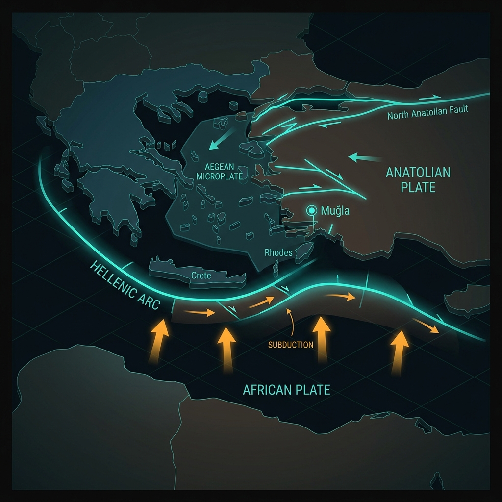
To understand why the earth here shakes so frequently, one must look beneath the Mediterranean’s azure surface, where the Aegean Microplate grinds against the Anatolian Plate in a complex geologic ballet. This boundary represents one of the most seismically active zones in Europe, driven by the northward subduction of the African Plate beneath the Aegean Sea—a process that generates both the volcanic islands dotting the horizon and the sudden, violent releases of energy that periodically convulse coastal Turkey and Greece.
The region has not been quiet in recent memory. In October 2021, a M6.4 earthquake struck just 36 kilometers from this latest event near Palekastro, Greece, causing significant damage and reminding residents that the Hellenic Arc remains locked in a slow-motion collision. That event followed a M6.5 tremor in 2020 near Néa Anatolí, Greece, and preceded a M6.2 shock near Emporeío earlier this year. This persistent activity—eight significant M6+ events within a 200-kilometer radius over the past four decades—marks the area as a textbook example of ongoing continental deformation.
What Makes Shallow Quakes Feel So Much Stronger?
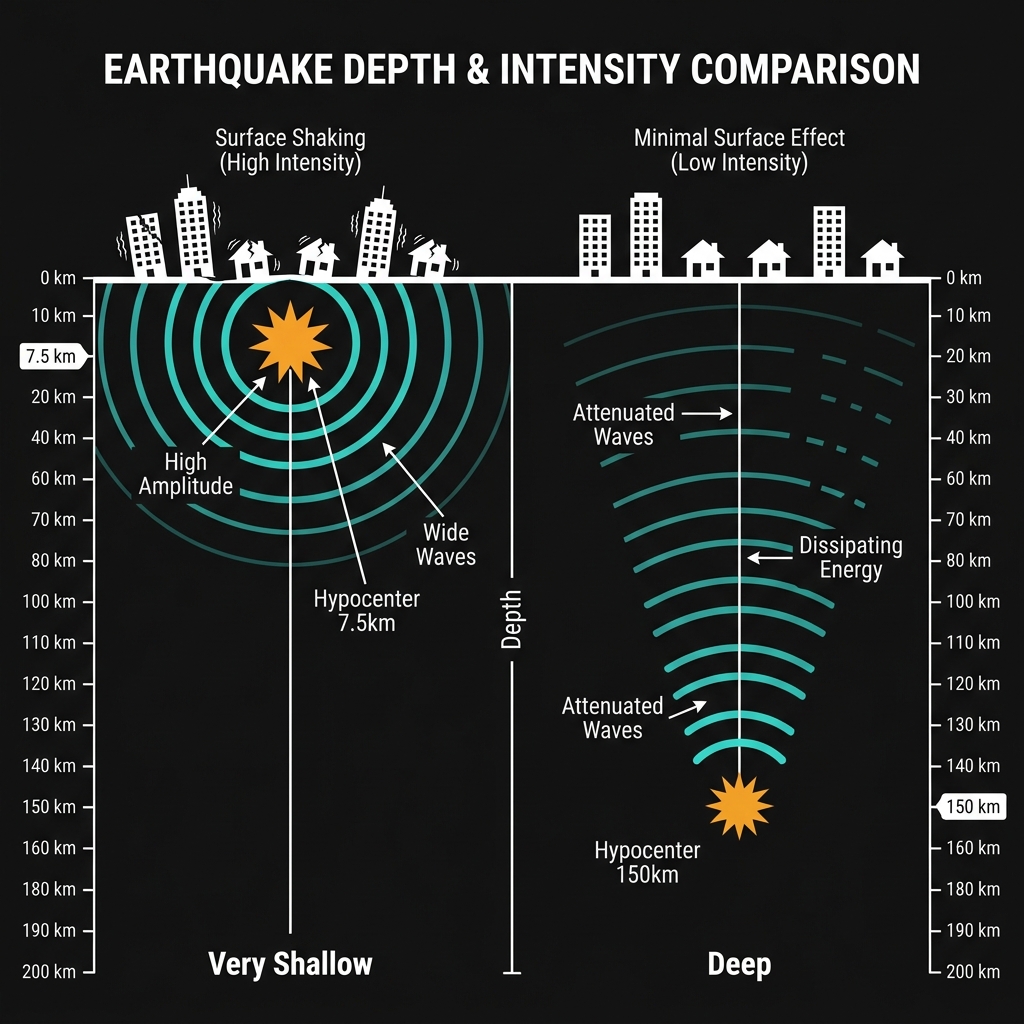
Seismologists classify earthquakes at depths of less than 70 kilometers as “shallow,” but this tremor’s 7.5-kilometer focus places it in the rarefied category of “very shallow” events. When an earthquake rupture occurs this close to the surface, the seismic energy has minimal rock mass to dissipate through before reaching human structures. The result is higher intensity shaking—measured on the Modified Mercalli Intensity scale—than a deeper quake of identical magnitude would produce.
To put this in perspective, consider the physics of energy propagation. A magnitude 4.7 earthquake at 150 kilometers depth might rattle windows and startle sleepers. At 7.5 kilometers, that same energy release can crack plaster, topple unsecured objects, and induce the sensation of a violent jolt rather than a rolling wave. The tremor was reportedly felt across the Muğla province and likely registered as moderate to strong shaking in nearby coastal settlements, despite its modest magnitude number.
| Recent Significant Events Near Muğla |
|---|
| Event |
| Akdeniz, Turkey (this event) |
| Palekastro, Greece |
| Néa Anatolí, Greece |
| Emporeío, Greece |
The comparison with the 2021 Palekastro earthquake is particularly instructive. That M6.4 event released roughly 250 times more energy than Saturday’s tremor, yet both occurred in the same tectonic neighborhood, driven by similar stress accumulation along the Hellenic Arc’s fault systems.
What Should We Watch For Next?
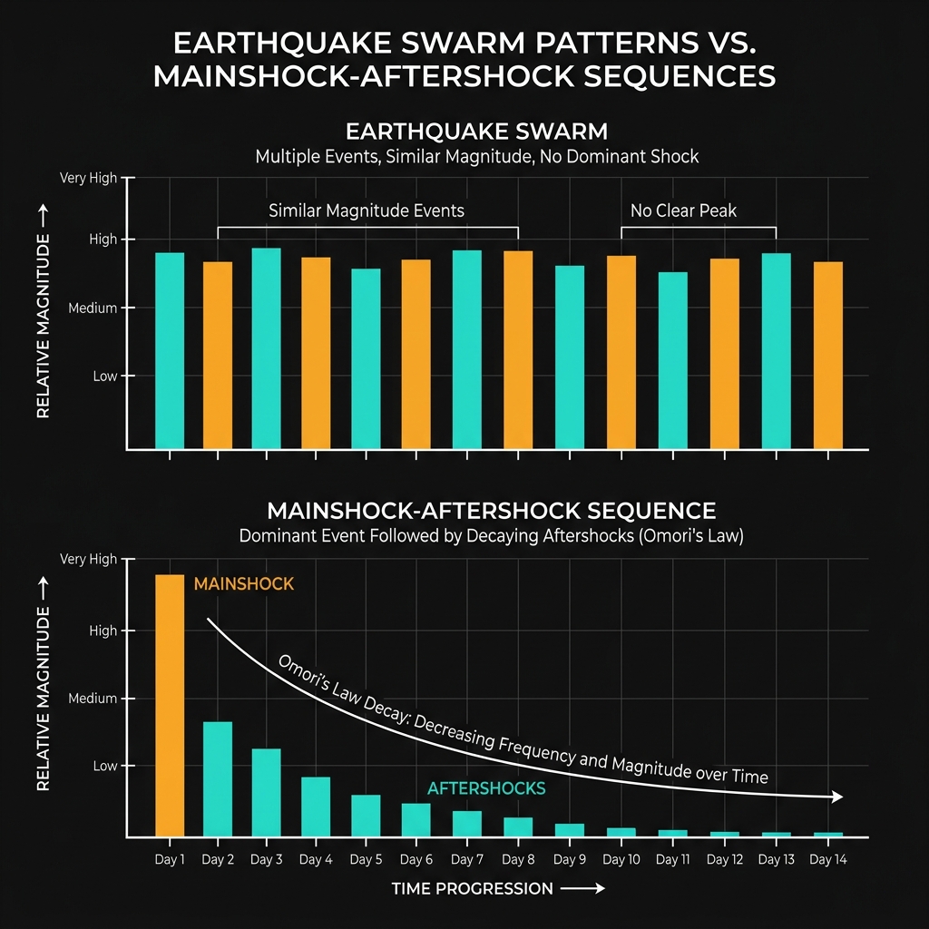
Earthquake swarms—clusters of tremors without a single dominant mainshock—often characterize regions experiencing complex fault interactions rather than simple pressure release on a single fracture. This 14-event sequence, culminating in the M4.7 shock, suggests the crust is adjusting to accumulated strain, possibly transferring stress between adjacent fault segments. Seismologists will monitor whether this represents the swarm’s climax or a foreshock to a larger event, though the latter remains statistically unlikely.
Residents should remain alert for aftershocks in the coming days, which could reach magnitude 3.0 or higher as the fault system settles. The shallow depth means even smaller aftershocks may produce noticeable shaking. However, the absence of tsunami warnings—confirmed by the event’s moderate magnitude and strike-slip faulting mechanism typical of this region—provides some reassurance for coastal communities.
Frequently Asked Questions
How strong was this earthquake?
The earthquake registered as magnitude 4.7 on the moment magnitude (MW) scale, which measures the total energy released. While this classifies as a light to moderate event, its extremely shallow depth of 7.5 kilometers amplified the ground shaking significantly, causing it to feel more intense than the number alone suggests.
Is there a tsunami risk from this earthquake?
No tsunami warning was issued for this event. Tsunamis typically require underwater displacement of the seafloor during earthquakes of magnitude 6.5 or greater, or significant submarine landslides triggered by shaking. This magnitude 4.7 event lacked the vertical seafloor displacement necessary to generate dangerous ocean waves.
Why is this area so seismically active?
The region sits at the complex boundary between the Aegean Microplate and the Anatolian Plate, where the African Plate subducts northward beneath the Aegean Sea. This tectonic convergence creates continuous stress that releases through frequent earthquakes, including the destructive M6.4 event in 2021 just 36 kilometers from this latest tremor.
Track this event live on the map!
Download GeoShake and get instant earthquake alerts.
Download GeoShake