The ground shook with violent immediacy. At just 10 kilometers depth—shallow enough to feel as though the earth cracked directly beneath your feet—a magnitude 6.2 earthquake ruptured near the remote northern reaches of Tonga on April 19, according to USGS data. The event struck 123 kilometers north-northeast of Hihifo, the administrative center of the Niuas island group, where the Pacific and Australian tectonic plates wage their perpetual, grinding war.
Why Is This Region So Seismically Active?
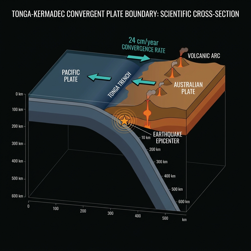
This is the Tonga-Kermadec subduction zone, arguably the most hyperactive tectonic boundary on Earth. Here, the Pacific Plate dives beneath the Australian Plate at rates exceeding 24 centimeters per year—the fastest subduction velocity measured anywhere on the planet.
Seismologists classify this setting as a convergent boundary, where one massive slab of oceanic crust is forced under another, creating a deep oceanic trench and, periodically, releasing enormous accumulated strain as earthquakes. The region has hosted five magnitude 7.0+ events since 1990, including the devastating M8.1 Samoa earthquake in 2009 that triggered a deadly tsunami. Today’s event fits this volatile pattern perfectly, representing the third quake to strike within a 200-kilometer radius over the past week, though it is by far the largest of this brief cluster.
What Does Such Shallow Depth Mean for Shaking?
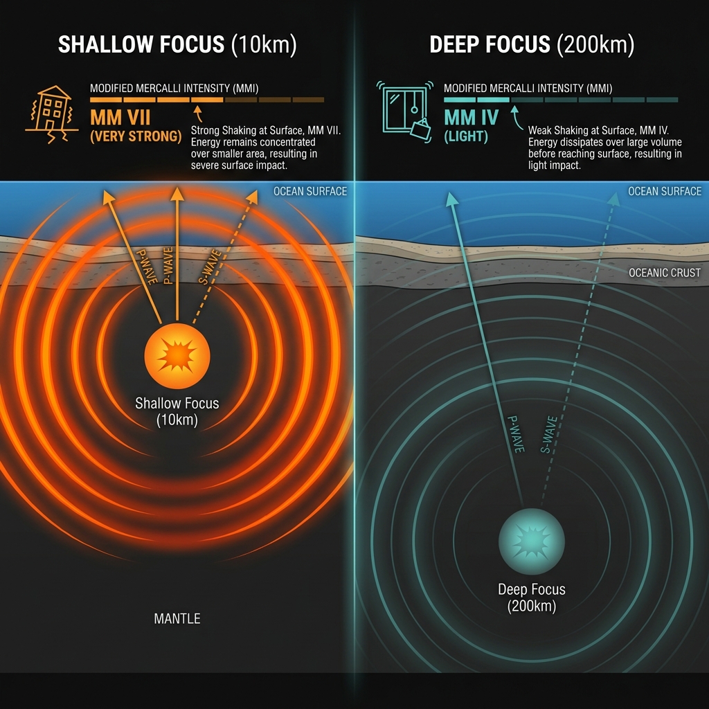
At just 10 kilometers depth, this earthquake struck within the upper crust, meaning seismic waves had minimal time to dissipate before reaching the surface. Seismologists refer to events less than 70 kilometers deep as “shallow-focus” earthquakes, and they typically produce the most intense shaking relative to their magnitude.
While a magnitude 6.2 might sound moderate—roughly equivalent to the energy released by the Hiroshima atomic bomb—the shallow depth amplifies its impact significantly. Residents in the Niuas islands likely experienced strong to very strong shaking, potentially knocking items from shelves and causing minor structural damage to unreinforced masonry buildings. The tremors may have been felt as far away as Samoa and Fiji, though the remote location means few instruments exist to confirm the exact felt extent.
Seismologists recognize that this specific segment of the subduction zone releases stress through frequent moderate-to-large earthquakes rather than storing it for centuries. When viewed against recent history, today’s earthquake continues an unsettling trend of significant shallow activity near the Niuas:
| Event | Magnitude | Distance from Hihifo | Depth | Year |
|---|---|---|---|---|
| 2009 Samoa Earthquake | 8.1 | 127 km | 18 km | 2009 |
| Tonga Deep Event | 7.6 | 157 km | 210 km | 2023 |
| Northern Tonga Quake | 7.4 | 43 km | 10 km | 1995 |
| Recent Event | 6.8 | 42 km | 10 km | 2022 |
| Today’s Event | 6.2 | 123 km | 10 km | 2026 |
This comparison reveals that while magnitude 6+ events are common here, the shallow depth matches the 1995 and 2022 events that caused localized damage to infrastructure in the Niuas.
What Should Residents Do?
Given the shallow depth and proximity to populated islands, residents should immediately inspect homes and buildings for fresh cracks in walls, shifted foundations, or damaged utility connections. Check water tanks and solar installations, which are particularly vulnerable to lateral shaking. While authorities have confirmed no tsunami threat from this event, remain vigilant for aftershocks—smaller quakes that typically follow within days—and have emergency kits prepared given the remote location and limited rapid response capabilities in the Niuas.
What Should We Watch For Next?
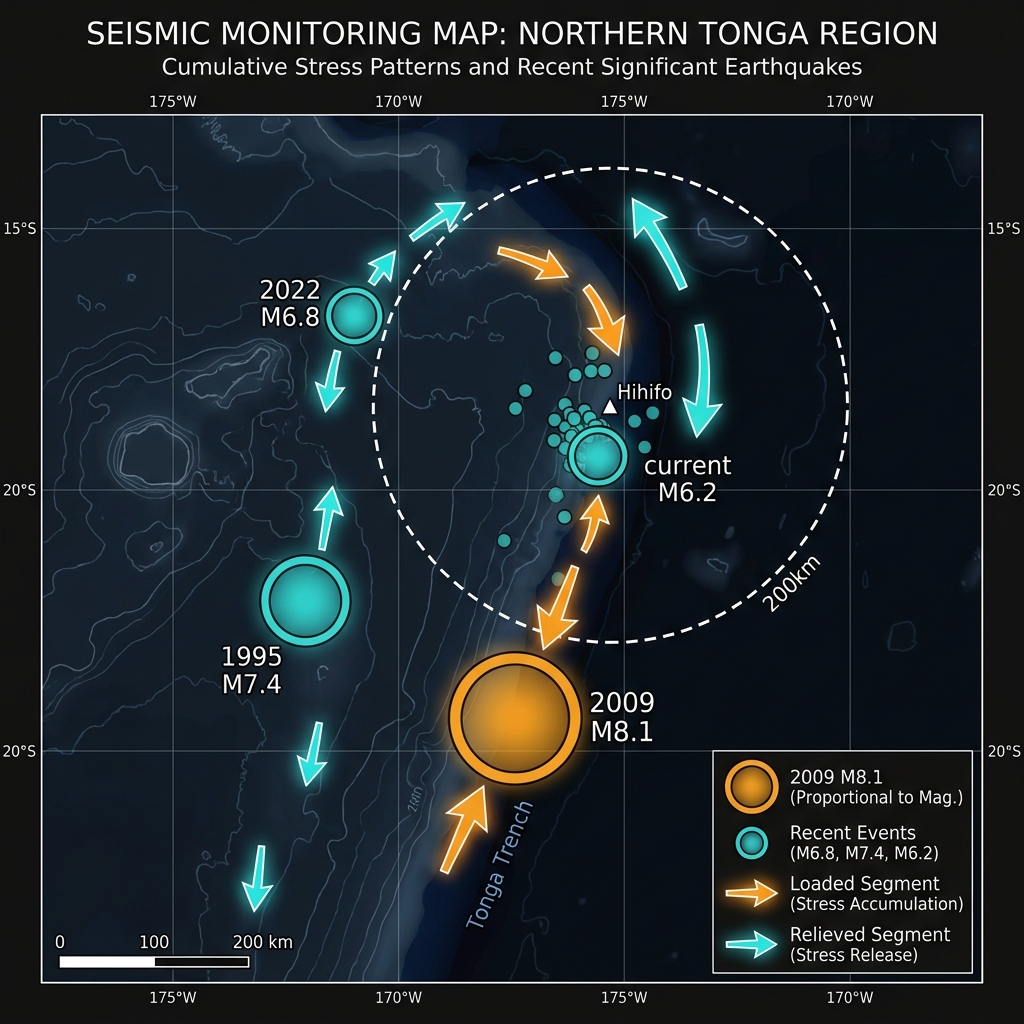
Geoscientists will monitor this sequence closely for the next 72 hours. Aftershocks are likely, though typically decreasing in magnitude and frequency. More significantly, this event adds to the cumulative stress loading on adjacent sections of the subduction zone. The 2009 M8.1 rupture began not far from this location, reminding us that these moderate quakes may be releasing stress or, conversely, transferring it to locked segments capable of generating much larger events. The preceding activity this week suggests this may be a short-lived cluster, but the region’s history demands continued vigilance. GeoShake will continue tracking microseismic activity across the Tonga Trench as this story develops.
Frequently Asked Questions
How strong was this earthquake?
A magnitude 6.2 earthquake releases approximately 15 kilotons of TNT equivalent energy, similar to the Hiroshima atomic bomb. However, because it occurred at only 10 kilometers depth, the shaking intensity felt at the surface would be significantly stronger than a deeper quake of the same magnitude, potentially reaching Modified Mercalli Intensity VII (Very Strong) near the epicenter.
Is there a tsunami risk?
No. According to USGS data, this earthquake poses no tsunami threat. The magnitude, while significant, was insufficient to displace the seafloor vertically in a way that would generate a tsunami wave, and no tsunami alerts were issued for this event.
Why does this area have so many earthquakes?
The Tonga-Kermadec subduction zone represents the collision boundary between the Pacific and Australian tectonic plates, where the Pacific Plate subducts beneath the Australian Plate at the fastest rate on Earth—over 24 centimeters per year. This rapid convergence creates immense friction and frequent ruptures along the plate interface, producing regular earthquakes ranging from magnitude 6 to 8.
Track this event live on the map!
Download GeoShake and get instant earthquake alerts.
Download GeoShake