
At just 10 kilometers beneath the surface, the earth ruptured with sudden violence. On April 19, 2026, a magnitude 6.1 earthquake struck 114 kilometers northeast of Hihifo, Tonga, according to USGS data, sending seismic waves racing through the shallow crust with minimal energy lost to the depths. The tremor struck at 17:34 UTC, its shallow focus amplifying the potential for strong ground shaking across the archipelago despite its moderate magnitude.
Why Is This Area So Seismically Active?
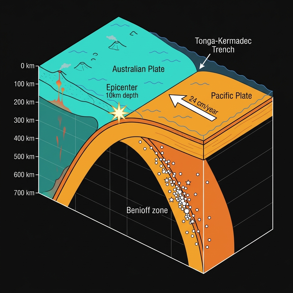
The Tonga Islands do not sit quietly. They rest upon one of the most active tectonic boundaries on Earth, where the Pacific Plate dives westward beneath the Australian Plate in a relentless process called subduction. This collision creates the Tonga-Kermadec Trench, an undersea chasm that hosts frequent seismic releases as the oceanic crust bends, breaks, and occasionally locks before snapping free.
This region has a long memory of violence. In 2009, a magnitude 8.1 earthquake—the Samoa Earthquake—struck just 118 kilometers away, claiming lives across multiple islands and generating a devastating tsunami. More recently, a magnitude 7.6 event rocked the area in 2023, roughly 155 kilometers from today’s epicenter. Seismologists classify this latest tremor as part of the ongoing stress release along the subduction interface, where the Pacific Plate descends at rates exceeding 24 centimeters per year, one of the fastest convergence zones globally.
What Does This Depth Mean for Shaking?
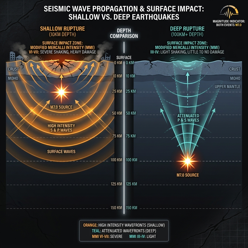
Depth determines destruction. When earthquakes occur just 10 kilometers down—barely six miles—they produce significantly stronger surface shaking than deeper events of equivalent magnitude. The seismic waves have little distance to travel before hitting communities, arriving with their energy largely intact.
To understand the difference, consider this comparison of recent regional events:
| Earthquake | Magnitude | Depth | Distance from Hihifo | Relative Impact |
|---|---|---|---|---|
| April 2026 (Current) | 6.1 | 10 km | 114 km NE | Strong shallow shaking |
| 2023 Event | 7.6 | Deep | 155 km WNW | Moderate distant shaking |
| 2022 Event | 6.8 | Shallow | 28 km NE | Very strong local impact |
| 2009 Samoa | 8.1 | Shallow | 118 km away | Catastrophic regional damage |
A magnitude 6.1 at this depth can produce Modified Mercalli Intensity VI to VII shaking—strong enough to crack plaster, overturn unsecured furniture, and frighten residents into evacuating buildings. While the epicenter sat offshore, the shallow rupture meant coastal areas likely felt the jolt more acutely than they would have from a deeper, more distant quake.
Seismologists classify this as a shallow crustal earthquake along the outer rise or upper plate of the subduction zone. These events differ from the deeper “Benioff zone” quakes that occur within the descending slab itself. This type of earthquake tells us that stress is accumulating not just at the plate interface miles below, but within the overriding Australian Plate itself—potentially increasing the complexity of regional hazard assessment.
What Should Residents Do Right Now?
Residents throughout the Niuatoputapu and Vava’u island groups should inspect their homes for fresh cracks in masonry or concrete, particularly around doorframes and window corners where structural stress concentrates first. Check water tanks and gas lines for leaks, as shallow quakes often jostle connections loose. Because this event occurred at 10 kilometers depth with no tsunami warning issued, the immediate threat has passed, but aftershocks—typically one magnitude unit smaller—could follow in the coming days. Secure heavy furniture and ensure emergency kits remain accessible, as shallow aftershocks can produce surprisingly sharp jolts even if smaller than the mainshock.
What Should We Watch For Next?
Geoscientists will monitor this sequence closely over the next 72 hours. Given the region’s history—similar magnitude 6.0+ events occurred in 2022 just 28 kilometers away and in 2017 only 20 kilometers distant—this rupture may represent either an isolated stress release or the beginning of a brief aftershock sequence. The USGS and Tonga Meteorological Service will continue tracking microseismicity for signs of migrating stress that could trigger adjacent fault segments. For now, the tectonic machinery of the Pacific Ring of Fire continues its slow, grinding operation, reminding us that in this part of the world, the ground is never truly still.
Frequently Asked Questions
How strong was this earthquake?
A magnitude 6.1 earthquake releases energy equivalent to approximately 50,000 tons of TNT, classifying it as a strong event. At 10 kilometers depth, it likely produced shaking intensity of VI to VII on the Modified Mercalli scale, meaning strong enough to cause minor damage to poorly constructed buildings and be felt by everyone in the region.
Is there a tsunami risk from this earthquake?
No tsunami warning was issued for this event according to USGS data. The earthquake’s magnitude of 6.1 and location 114 kilometers offshore did not generate sufficient vertical seafloor displacement to create a tsunami threat, though local sea level disturbances sometimes occur near epicenters.
Why is this area so seismically active?
The Tonga region sits at the convergence of the Pacific and Australian tectonic plates, where the Pacific Plate subducts beneath Tonga at one of the fastest rates on Earth—over 24 centimeters annually. This creates frequent earthquakes along the plate boundary, including the devastating 2009 M8.1 Samoa earthquake just 118 kilometers from today’s epicenter.
Track this event live on the map!
Download GeoShake and get instant earthquake alerts.
Download GeoShake