
The tremor originated just ten kilometers beneath the rugged surface—shallow enough that seismic waves had scarcely attenuated before rippling across the high-altitude grasslands. On May 22, 2026, a magnitude 5.1 earthquake struck 296 kilometers northwest of Nagqu in China’s Qinghai province, according to USGS data, releasing energy in a remote stretch of the Tibetan Plateau that has witnessed three magnitude-6 or greater temblors within the past four decades. The extreme shallowness of this event places it within the most brittle, fracture-prone layer of Earth’s crust, where even moderate quakes can deliver a sharp jolt to the surface above.
Why Is This High-Altitude Zone So Prone to Powerful Quakes?
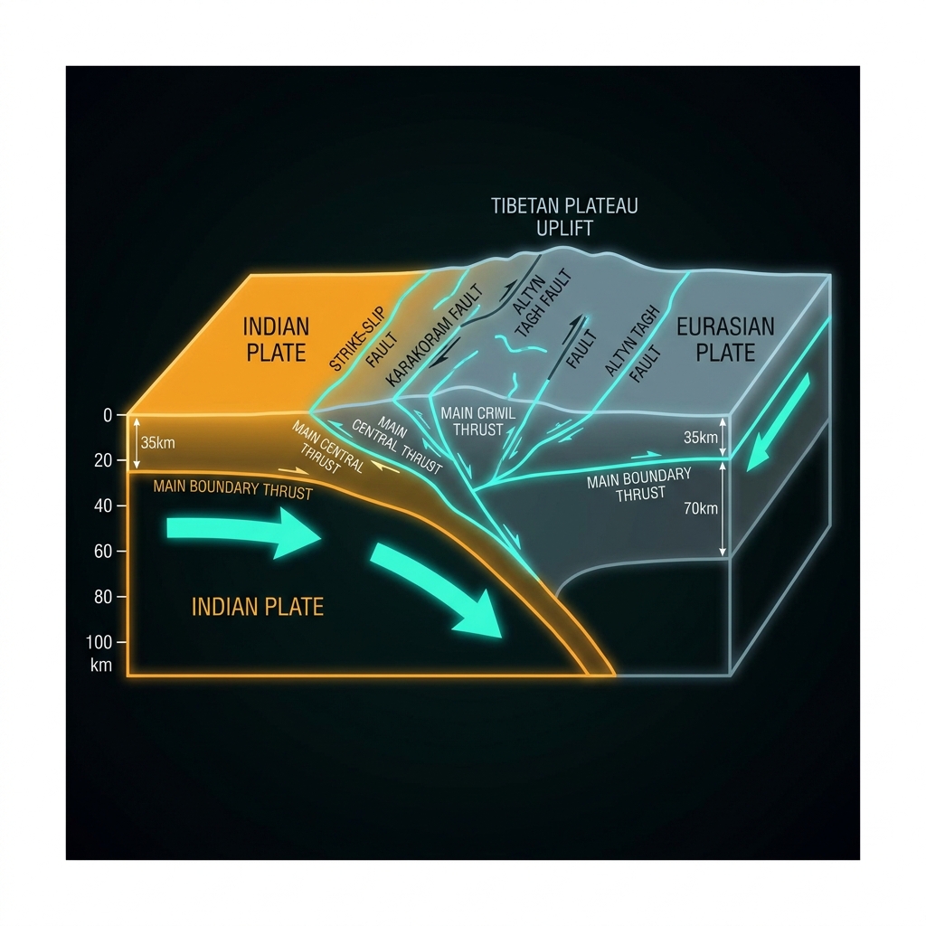
This isolated region sits at the heart of the planet’s most dramatic ongoing continental collision. Here, the Indian Plate drives northward into the Eurasian Plate at roughly the rate your fingernails grow, a relentless convergence that began approximately 50 million years ago and continues to thrust the Tibetan Plateau skyward. Seismologists classify this as an active orogenic belt, where the crust doubles in thickness through faulting and folding rather than through one plate sliding beneath another as occurs in oceanic subduction zones.
The result is a lattice of strike-slip and thrust faults that cut through thickened continental crust, storing elastic strain that releases in sudden ruptures. The historical record speaks to this volatility: a magnitude 6.4 earthquake rocked southern Qinghai in 1986, followed by a magnitude 6.2 event just two years later in 1988, while a magnitude 6.0 temblor struck western Xizang in 2004. Each occurred within 200 kilometers of Friday’s epicenter, clustering around the same network of deep crustal structures that accommodate the ongoing squeeze between Asia and India.
What Does the Shallow Depth Mean for Local Impact?
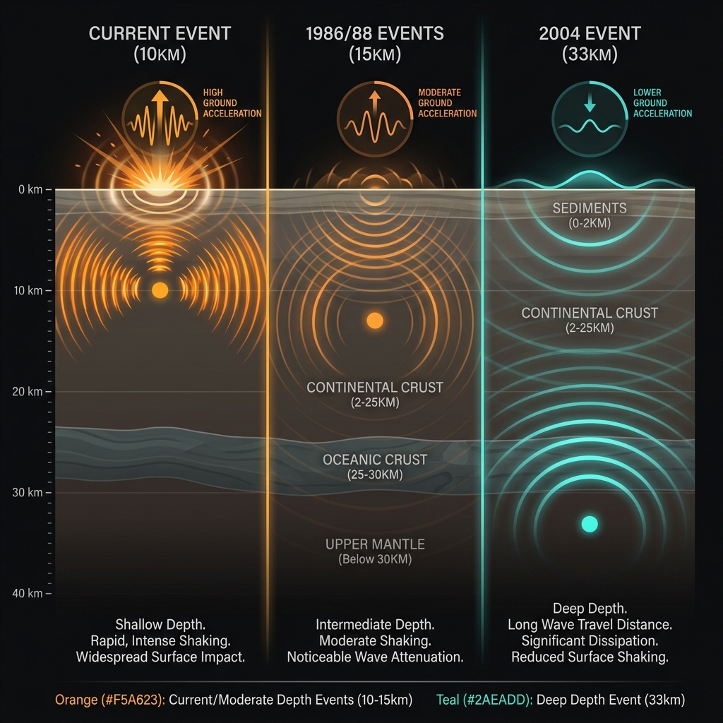
At merely ten kilometers deep, this earthquake qualifies as extremely shallow—nestled within the upper crust where temperatures remain cool enough for rocks to behave in a brittle, breakable fashion. For perspective, the devastating 1986 and 1988 events both ruptured at approximately 15 kilometers depth, while the 2004 quake originated near 33 kilometers, within the lower crust. The shallow focus of Friday’s event means the seismic energy had roughly half the distance to travel compared to those earlier temblors, potentially amplifying ground acceleration at the surface despite the moderate magnitude.
In practical terms, a magnitude 5.1 earthquake typically produces light to moderate shaking—sensation comparable to a heavy truck passing immediately outside a building. However, the ten-kilometer depth here likely intensified the perceived shaking for anyone in the immediate vicinity, creating sharper jolts rather than the rolling motion characteristic of deeper events. Had this rupture occurred beneath a densely populated urban center, the shallow focus could have translated to more pronounced building movement and potential minor structural damage. In this sparsely populated high-altitude region, however, impacts remained minimal, with no immediate reports of casualties or infrastructure disruption.
| Historical Event | Year | Magnitude | Approximate Depth | Distance from Current Epicenter |
|---|---|---|---|---|
| Southern Qinghai | 1986 | 6.4 | ~15 km | 174 km |
| Southern Qinghai | 1988 | 6.2 | ~15 km | 180 km |
| Western Xizang | 2004 | 6.0 | ~33 km | 97 km |
| Current Event | 2026 | 5.1 | 10 km | — |
What Should We Monitor in the Coming Days?
Following a shallow crustal rupture in this tectonic setting, seismologists will watch for aftershocks that may persist for days or weeks as the crust adjusts to the new stress distribution. While these subsequent tremors typically decrease in both frequency and magnitude over time, the historical pattern of magnitude-6 events occurring roughly every decade or two in this vicinity suggests the regional fault systems remain critically stressed. Friday’s earthquake could represent an isolated stress adjustment on a minor fault segment, or it may signal the reactivation of a larger structure capable of hosting more significant ruptures. Although the probability of a subsequent larger mainshock remains statistically low, the proximity to past major events warrants continued scrutiny through the regional seismic networks that monitor this restless plateau.
GeoShake will continue tracking activity across the Tibetan Plateau as this high-altitude collision zone continues its slow-motion transformation, millimeter by millimeter, quake by quake.
Frequently Asked Questions
How strong was this earthquake?
A magnitude 5.1 earthquake is considered moderate on the seismic scale. It typically produces light to moderate shaking felt by nearly everyone in the vicinity, with the potential to cause very light damage to well-built structures. The shallow depth of ten kilometers meant the seismic waves had less distance to travel through the earth, potentially making the shaking feel sharper and more intense than it would from a deeper quake of the same magnitude.
Is there a risk of a tsunami?
No. According to USGS data, this earthquake poses no tsunami risk. Tsunamis require specific conditions—typically large underwater earthquakes that displace the seafloor vertically. This event occurred deep within the continental interior of the Tibetan Plateau, hundreds of kilometers from any ocean coastline, making tsunami generation physically impossible.
Why does this specific area experience so many significant earthquakes?
The Tibetan Plateau sits at the collision boundary between the Indian and Eurasian tectonic plates. As India continues pushing northward into Asia at roughly 40-50 millimeters per year, the crust thickens and fractures, creating a complex network of active faults. This ongoing continental collision produces some of the world’s most significant seismic hazards, with the region’s extreme high-altitude terrain itself being a direct result of millions of years of tectonic compression and uplift.
Track this event live on the map!
Download GeoShake and get instant earthquake alerts.
Download GeoShake