Global volcanic monitoring networks detected 33 distinct eruptive events across 19 active volcanoes during the 24-hour period ending May 18, 2026, according to the Smithsonian Global Volcanism Program. The most significant activity concentrated in Russia’s Kamchatka Peninsula, where Klyuchevskoy and Bezymianny produced sustained eruptions, while ash advisories dominated the Andean region with Sabancaya and Sangay ejecting debris into commercial flight corridors. Data compiled from the USGS Volcano Hazards Program, local observatories, and Volcanic Ash Advisory Centers (VAACs) indicates elevated unrest across the Pacific Ring of Fire, requiring heightened vigilance from aviation authorities and nearby populations.
Which Volcanoes Showed Significant Activity Today?
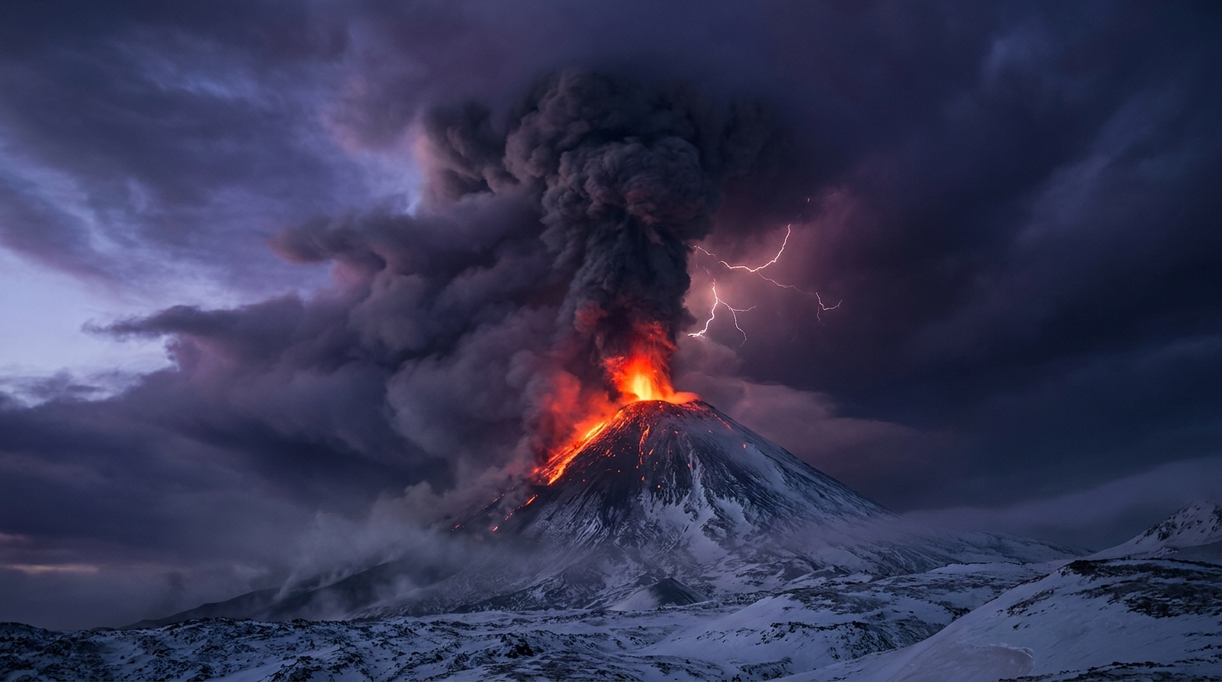
The Kamchatka Peninsula in Russia’s Far East hosted the most intense eruptive sequences during this reporting period. Klyuchevskoy, Eurasia’s highest active volcano at 4,835 meters, generated a discrete explosive event at 03:22 UTC on May 18, sending eruption columns into the atmosphere according to the Kamchatkan Volcanic Eruption Response Team (KVERT). Bezymianny, located approximately 20 kilometers southwest of Klyuchevskoy, produced its own eruption at 03:07 UTC, with monitoring stations detecting seismicity consistent with lava dome growth or collapse events.
In South America, Peru’s Sabancaya volcano maintained persistent ash emissions reaching 7,600 meters (24,900 feet) above sea level, triggering aviation alerts from the Buenos Aires VAAC. Ecuador’s Sangay volcano, one of the continent’s most active and remote peaks, generated ash clouds rising to 6,400 meters (21,000 feet) at 02:15 UTC, posing hazards to trans-Andean flight routes. Both volcanoes exhibit ongoing open-vent behavior characteristic of their current eruptive cycles.
The Americas also saw continued activity at Guatemala’s Santiaguito and Fuego volcanoes, with the former producing degassing and occasional explosions from the Caliente dome. Indonesia contributed multiple entries to the daily tally, with Dukono, Semeru, and Ibu maintaining frequent Strombolian activity and ash venting. The Philippines’ Mayon and Canlaon volcanoes showed elevated unrest, while New Zealand’s White Island (Whakaari) and Vanuatu’s Aoba (Ambae) recorded minor hydrothermal or gas-driven emissions.
How Dangerous Are Current Ash Emissions?
Today’s most significant ash hazards originate from the Andean volcanic belt, where Sabancaya and Sangay injected particulate matter into the upper troposphere. The 7,600-meter plume from Sabancaya extends well into commercial aviation cruising altitudes, with volcanic glass shards capable of causing catastrophic engine failure if ingested by jet turbines. Communities downwind in southern Peru should prepare for ashfall that can contaminate water supplies, damage agricultural crops, and cause respiratory distress among vulnerable populations.
Sangay’s 6,400-meter emission presents similar aviation risks for flights between South America and the Caribbean, though the volcano’s remote location in the Amazonian foothills minimizes direct population exposure. Volcanic ash from these events can travel hundreds of kilometers before dissipating, with particulate dispersion models from the Washington VAAC showing potential drift toward the east-northeast over the Brazilian Amazon.
Ground-based hazards remain concentrated in Kamchatka, where explosive activity at Klyuchevskoy and Bezymianny could produce pyroclastic flows or lahars (volcanic mudflows) during snowmelt conditions. The Russian Academy of Sciences maintains Orange aviation color codes for both volcanoes, indicating ongoing eruptions with limited hazards beyond the immediate summit regions.
What Should Aviation Professionals Know About Today’s Activity?
Pilots and dispatchers should consult updated Volcanic Ash Advisory Center (VAAC) products for the Washington and Buenos Aires centers covering the Americas, and the Tokyo VAAC for Kamchatka routes. Sabancaya’s ash cloud reached FL250 (flight level 250), requiring rerouting for aircraft traversing southern Peru between Lima and La Paz or São Paulo. Sangay’s plume extends to approximately FL210, affecting lower-altitude routes through Ecuadorian airspace.
Kamchatka’s dual eruptions require caution for transpacific flights approaching Russian Far East airspace from Alaska or Japan. While specific ash cloud heights for Klyuchevskoy and Bezymianny were not quantified in initial reports, historical patterns suggest these volcanoes frequently produce plumes exceeding 10,000 meters. Operators should monitor NOTAMs (Notices to Airmen) for temporary flight restrictions around UHPP (Petropavlovsk) airspace.
The International Air Transport Association (IATA) recommends that flight crews treat volcanic ash advisories as mandatory avoidance zones rather than areas for visual navigation, as ash clouds are invisible to radar and can appear as innocuous weather formations.
Active Volcanoes Summary Table
| Volcano | Location | Event Type | Alert Level |
|---|---|---|---|
| Klyuchevskoy | Kamchatka, Russia | Eruption | Orange |
| Bezymianny | Kamchatka, Russia | Eruption | Orange |
| Sabancaya | Peru | Ash Advisory | Yellow |
| Sangay | Ecuador | Ash Advisory | Yellow |
| Santiaguito | Guatemala | Eruption | Not Specified |
| Fuego | Guatemala | Eruption | Not Specified |
| Reventador | Ecuador | Eruption | Not Specified |
| Shiveluch | Kamchatka, Russia | Eruption | Not Specified |
| Semeru | Indonesia | Eruption | Not Specified |
| Dukono | Indonesia | Eruption | Not Specified |
| Ibu | Indonesia | Eruption | Not Specified |
| Mayon | Philippines | Unrest | Not Specified |
| Canlaon | Philippines | Unrest | Not Specified |
| White Island | New Zealand | Hydrothermal | Not Specified |
| Aoba | Vanuatu | Gas Emission | Not Specified |
| Puracé | Colombia | Unrest | Not Specified |
| Central Bismarck Sea | Papua New Guinea | Unrest | Not Specified |
Data sources: Smithsonian Global Volcanism Program, USGS, KVERT, IG-EPN (Ecuador), IG-Peru, PHIVOLCS
Frequently Asked Questions
How does volcanic ash affect aircraft engines?
Volcanic ash poses severe risks to aircraft because it can melt inside jet engines, causing them to stall or fail completely when the molten material solidifies on turbine blades. The abrasive particles also damage windshields, fuselages, and navigation systems within minutes of exposure. Pilots rely on VAAC (Volcanic Ash Advisory Center) forecasts to avoid these dangerous corridors, as ash clouds can travel thousands of kilometers from the source volcano while remaining invisible to onboard weather radar.
What safety measures should communities near active volcanoes take?
Communities living near active volcanoes should maintain emergency kits with N95 masks, goggles, and sealed water containers to protect against ashfall, and memorize evacuation routes established by local civil protection agencies. When authorities raise alert levels, residents should seal windows and doors, avoid driving which can stir up ash particles, and stay indoors to prevent respiratory issues from volcanic glass fragments. Monitoring local geological surveys and the Smithsonian Global Volcanism Program provides early warning of escalating activity that might require immediate evacuation.
Where can pilots find real-time volcanic ash advisories?
Pilots can access real-time volcanic ash advisories through the nine global Volcanic Ash Advisory Centers (VAACs), including the Washington VAAC for the Americas and the Tokyo VAAC for Asia and Kamchatka. These agencies issue color-coded warnings and forecast ash cloud dispersion using satellite data, ground-based sensors, and atmospheric modeling. Additionally, the International Civil Aviation Organization (ICAO) maintains centralized portals where flight crews can check NOTAMs (Notices to Airmen) for temporary flight restrictions near erupting volcanoes like today’s active systems in Kamchatka and the Andes.
Track this event live on the map!
Download GeoShake and get instant earthquake alerts.
Download GeoShake