Volcanic activity remained elevated across the Pacific Ring of Fire and beyond during the past 24 hours, with the Smithsonian Global Volcanism Program recording 47 distinct volcanic events globally. Notable developments include renewed explosive activity at Mayon in the Philippines, a significant submarine eruption in the Central Bismarck Sea near Papua New Guinea, and sustained ash emissions from Sabancaya in Peru. Monitoring agencies including the USGS, PHIVOLCS, and IG-EPN continue to track these systems closely as several volcanoes maintain elevated alert statuses.
Which Volcanoes Erupted Today?
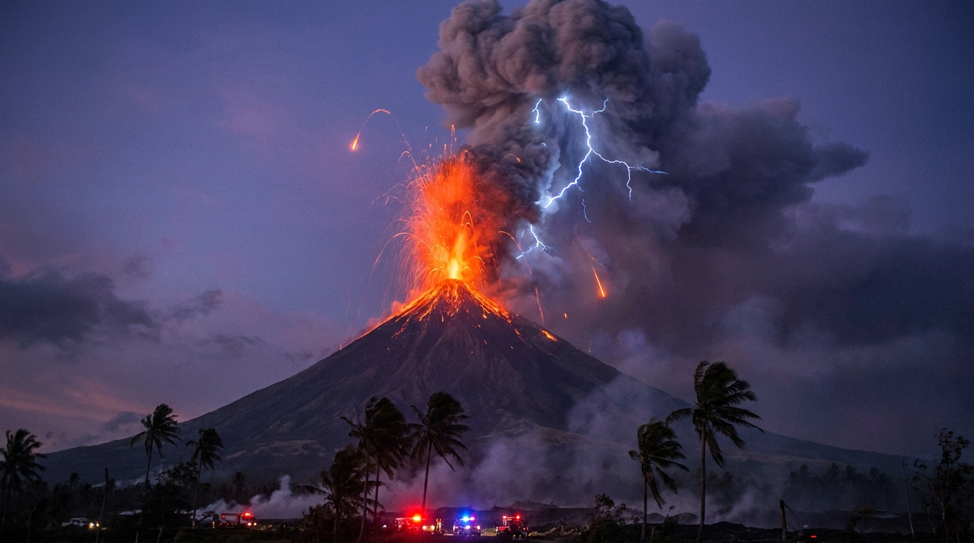
Mayon – The Philippines’ most active volcano generated a new eruption on May 19 at 22:27 UTC, according to the Smithsonian Global Volcanism Program. Located in Albay Province on Luzon Island, Mayon produced explosive activity visible from surrounding communities. The Philippine Institute of Volcanology and Seismology (PHIVOLCS) maintains continuous seismic monitoring of the symmetrical stratovolcano, which is renowned for its near-perfect cone shape.
Central Bismarck Sea – A submarine volcanic eruption occurred in the Admiralty Islands region of Papua New Guinea at 09:47 UTC on May 19. This underwater event, reported by the Smithsonian Global Volcanism Program, highlights ongoing geothermal unrest in the Bismarck Archipelago. The volcano’s submerged nature presents unique monitoring challenges, with activity typically detected through hydroacoustic networks and satellite observations of discolored water.
Sabancaya (Peru) – Peru’s Geophysical Institute (IGP) reported sustained eruptive activity at Sabancaya, maintaining an Orange alert level. The 5,967-meter stratovolcano in the Andes’ Colca Valley continues to produce gas and ash emissions reaching variable altitudes. Authorities have restricted access to the volcano’s immediate vicinity due to persistent explosive potential and the risk of ballistics near the summit.
Santiaguito – The Guatemalan complex, which includes the Santa María volcanic system, registered explosive activity with an Advisory alert level according to the Smithsonian GVP. The Santiaguito lava dome complex remains one of Central America’s most active eruptive centers, producing regular ash-laden explosions and block-and-ash flows. Prevailing westerly winds typically carry ejecta toward populated areas in the Quetzaltenango department.
Sangay (Ecuador) – The Institute of Geophysics of the National Polytechnic School (IG-EPN) documented continued eruptive activity at Sangay, one of Ecuador’s most active volcanoes. Located in the Morona Santiago province, this remote stratovolcano frequently produces ash plumes that drift toward the Amazon basin. The volcano’s steep profile contributes to the rapid generation of volcanic material during eruptive episodes.
How Dangerous Are the Ash Emissions?
Ash plumes from today’s activity pose varying degrees of risk to local populations and infrastructure. At Sabancaya, the Orange alert level indicates ongoing moderate-to-high explosive activity with potential for pyroclastic flows and ashfall affecting communities downwind within a 12-kilometer radius. The volcano has maintained this elevated status due to persistent seismicity registering hundreds of daily earthquakes and sustained gas output exceeding 3,000 tons of sulfur dioxide per day.
Mayon’s eruption generated volcanic ash that could impact agricultural areas in the Bicol Region, particularly affecting coconut plantations and rice fields. PHIVOLCS advises residents to wear N95 masks and goggles during ashfall events to prevent respiratory irritation and eye injury from the fine volcanic glass particles. Prevailing wind patterns will determine the distribution of any ash clouds generated by the continuing unrest.
Sangay’s frequent explosions typically produce ash that affects remote areas, though occasional shifts in wind direction can impact populated zones including the towns of Macas and Alausí. The volcano’s activity often generates hot lahars during rainfall events, threatening drainage systems on its flanks.
What Should Aviation Know?
Volcanic ash clouds present significant hazards to aviation, with today’s activity requiring particular attention in Southeast Asian and South American airspace. While specific aviation color codes were not immediately available for all events, the sustained nature of activity at Sabancaya and Mayon suggests potential for ash encounters at cruising altitudes exceeding 30,000 feet. Pilots should treat volcanic ash advisories as mandatory restrictions due to the risk of engine flameout and abrasion of flight surfaces.
The Central Bismarck Sea submarine eruption could produce low-altitude steam and ash clouds if explosive activity intensifies or if the vent approaches the surface. Maritime traffic and low-flying aircraft in the Admiralty Islands region should monitor NOTAMs (Notices to Airmen) for updates regarding temporary flight restrictions. The remote location complicates visual confirmation of ash plumes.
Operations in Central America require awareness of Santiaguito’s ongoing dome collapses and explosions, which frequently send ash clouds to 4,000-5,000 meters above sea level. Similarly, Ecuadorian airspace near Sangay demands continuous monitoring as the volcano’s frequent eruptions can develop rapidly without precursor warning.
Which Other Volcanoes Show Elevated Unrest?
Beyond the primary highlights, numerous systems maintained persistent thermal anomalies and seismicity indicating magmatic movement. Bezymianny in Russia’s Kamchatka Peninsula showed continued dome growth and seismic tremor, while Indonesia’s archipelago hosted multiple active systems including Semeru, Dukono, Ibu, and Merapi, reflecting the region’s intense subduction dynamics.
The Philippines experienced concurrent activity at Taal, Canlaon, and Bulusan alongside Mayon, creating a complex monitoring environment for PHIVOLCS. Ecuador’s Reventador joined Sangay in producing detectable thermal signatures and lava flows. Mexico’s Popocatépetl continued its long-duration eruptive sequence with regular exhalations containing ash and incandescent fragments.
| Volcano | Location | Event Type | Alert Level |
|---|---|---|---|
| Mayon | Albay, Philippines | Explosive Eruption | Level 2 (Alert) |
| Central Bismarck Sea | Admiralty Islands, Papua New Guinea | Submarine Eruption | Unspecified |
| Santiaguito | Quetzaltenango, Guatemala | Dome Collapse/Explosion | Advisory |
| Sabancaya | Arequipa, Peru | Sustained Ash Emission | Orange |
| Sangay | Morona Santiago, Ecuador | Strombolian Eruption | Moderate/High |
| Fuego | Escuintla, Guatemala | Strombolian Activity | Orange |
| Bezymianny | Kamchatka, Russia | Lava Dome Growth | Yellow |
| Semeru | East Java, Indonesia | Vulcanian Eruption | Level II (Waspada) |
| Canlaon | Negros Island, Philippines | Volcanic Unrest | Level 1 |
| Dukono | Halmahera, Indonesia | Continuous Ash | Level II |
| Popocatépetl | Mexico State, Mexico | Minor Explosions | Yellow Phase 2 |
| Reventador | Napo, Ecuador | Lava Flows | Orange |
| Ibu | Halmahera, Indonesia | Lava Dome Eruption | Level III (Siaga) |
| Puracé | Cauca, Colombia | Seismic Swarm | Yellow |
| Krakatau | Sunda Strait, Indonesia | Thermal Anomaly | Level II |
| Kupreanof | Alaska, United States | Ground Deformation | Green |
| Kerinci | Sumatra, Indonesia | Gas Emissions | Level II |
| Karangetang | Siau Island, Indonesia | Lava Dome | Level III |
| Gamalama | Ternate, Indonesia | Minor Explosions | Level II |
| Santa María | Quetzaltenango, Guatemala | Dome Collapse | Advisory |
| Awu | Sangihe Islands, Indonesia | Seismicity | Level II |
| Bulusan | Sorsogon, Philippines | Phreatic Bursts | Level 1 |
| Taal | Batangas, Philippines | Low-level Unrest | Level 1 |
| Bur ni Telong | Sumatra, Indonesia | Seismic Activity | Level II |
| Dempo | Sumatra, Indonesia | Degassing | Level I |
| Merapi | Central Java, Indonesia | Dome Growth | Level III |
Frequently Asked Questions
What does an Orange alert level mean for volcanic activity?
An Orange alert indicates that a volcano is exhibiting heightened unrest with increased likelihood of eruption, or that an ongoing eruption poses limited hazards beyond the immediate vicinity. According to the USGS and international monitoring standards, this level signifies that communities and aviation should prepare for potential ashfall, lahars, or pyroclastic flows while maintaining heightened vigilance for rapid escalation to Red status.
How do scientists monitor submarine volcanoes like the Central Bismarck Sea?
Submarine volcanic activity is detected through a combination of hydroacoustic sensors that record underwater explosions, satellite imagery identifying water discoloration or thermal anomalies at the surface, and seismic networks on nearby islands. The Smithsonian Global Volcanism Program and regional agencies like the Rabaul Volcano Observatory track these events despite the technical challenges of monitoring submerged systems that may not produce visible above-water plumes.
Why are there so many active volcanoes in Indonesia and the Philippines?
Both nations lie along the Pacific Ring of Fire, where the collision of tectonic plates generates subduction zones that fuel volcanic arcs. The Philippine Sea Plate, Australian Plate, and Eurasian Plate interactions create numerous magma chambers beneath these archipelagos, resulting in the world’s highest density of active volcanoes. According to the Smithsonian GVP, Indonesia alone hosts over 120 historically active volcanoes due to this complex tectonic setting.
Track this event live on the map!
Download GeoShake and get instant earthquake alerts.
Download GeoShake