Global volcanic monitoring networks tracked 22 discrete eruptive events over the past 24 hours, with significant ash advisories issued for Kamchatka’s Shiveluch and Bezymianny volcanoes alongside Indonesia’s Semeru, according to the Smithsonian Global Volcanism Program and regional Volcanic Ash Advisory Centers (VAAC). Explosive activity along the Pacific Ring of Fire generated ash columns reaching 7,600 meters above sea level, prompting immediate aviation alerts for trans-Pacific flight corridors. A new eruption was also confirmed in the Central Bismarck Sea near Papua New Guinea, adding maritime hazards to today’s volcanic threats.
Which Volcanoes Generated Ash Advisories Today?
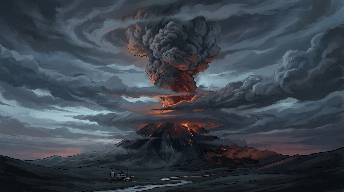
Shiveluch on Russia’s Kamchatka Peninsula produced the highest ash plume of the reporting period, with VAAC Tokyo confirming emissions reaching 7,600 meters (24,900 feet) above sea level at 03:15 UTC on May 23. The volcano, one of Kamchatka’s most active, continues its ongoing dome-building phase punctuated by explosive collapses that generate pyroclastic flows and ash clouds. According to KVERT (Kamchatka Volcanic Eruption Response Team), the extrusive lava dome remains unstable, with periodic phreatic explosions capable of sending ash into upper tropospheric flight levels without warning.
Bezymianny, located approximately 70 kilometers southeast of Shiveluch, also triggered an ash advisory following observations of a 7,000-meter (23,000-foot) ash cloud reported at 06:15 UTC on May 22. This stratovolcano, which experienced a catastrophic sector collapse in 1956, currently exhibits classic dome-fed eruptive behavior with periodic ash venting and block-and-avalanche activity. The aviation color code remains elevated as the lava dome continues to grow within the 1956 explosion crater, presenting ongoing hazards to regional air traffic.
Semeru in East Java, Indonesia, generated a significant ash advisory at 00:45 UTC on May 23, with PVMBG (Indonesian Center for Volcanology and Geological Hazard Mitigation) confirming ash heights of 4,600 meters (15,100 feet). The volcano has maintained nearly continuous Strombolian activity since 2014, with frequent Vulcanian explosions producing pyroclastic flows down the Kembar and Kobokan drainages. Today’s ash emission drifted northwest toward commercial flight routes connecting Australia and Southeast Asia.
What Eruption Occurred in the Central Bismarck Sea?
A significant submarine or emergent eruption was detected in the Central Bismarck Sea near the Admiralty Islands of Papua New Guinea at 05:56 UTC on May 22, according to the Smithsonian Global Volcanism Program. Unlike the subaerial explosions at Kamchatka and Java, this maritime event poses distinct hazards including potential tsunami generation, pumice raft formation, and acidification of local waters. The Rabaul Volcano Observatory and maritime monitoring agencies are tracking thermal anomalies and discolored water plumes that may indicate shallow-water explosive activity or nascent island formation.
Submarine eruptions in this tectonically active region frequently produce temporary islands composed of tephra and pumice that erode within months, though they can persist if magma supply remains robust. Mariners in the Bismarck Sea should maintain vigilant watch for floating volcanic debris and sudden water discoloration, while coastal communities on nearby islands should monitor for unusual tidal fluctuations that could signal underwater explosive sequences.
How Does Today’s Activity Impact Aviation Safety?
The ash clouds reported by VAAC Tokyo and VAAC Darwin today penetrate critical commercial flight levels, with Shiveluch’s 7,600-meter plume extending into the upper troposphere where long-haul aircraft typically cruise between 9,000 and 12,000 meters. Volcanic ash presents catastrophic risks to jet engines through melting and fusion of silicate particles onto turbine blades, potentially causing immediate engine failure and complete power loss. Bezymianny’s slightly lower 7,000-meter column similarly affects northern Pacific routes connecting North America and Asia, while Semeru’s 4,600-meter emissions primarily threaten domestic Indonesian flights and trans-Australian corridors.
Pilots operating near these volcanic systems rely on nine distinct VAACs worldwide to provide updated ash concentration forecasts and recommended avoidance zones. Today’s advisories implement standard procedures requiring minimum 10-nautical-mile separation from visible ash clouds, though dynamic wind patterns in the upper atmosphere can disperse these plumes hundreds of kilometers from their source within hours. Airlines have begun implementing contingency routing around the Kamchatka Peninsula and eastern Java to ensure passenger safety while minimizing fuel penalties.
Which Other Volcanoes Remain Under Close Observation?
Beyond the four volcanoes generating specific ash advisories, monitoring agencies reported ongoing activity at eight additional volcanic systems during the past 24 hours. Fuego in Guatemala continues its persistent Strombolian activity with frequent lava flows and ash emissions affecting local communities, according to INSIVUMEH (National Institute for Seismology, Volcanology, Meteorology and Hydrology). The Philippine Institute of Volcanology and Seismology (PHIVOLCS) maintains elevated alert levels for Mayon and Canlaon, with Mayon exhibiting lava dome growth and Canlaon showing heightened seismic unrest and degassing.
In Indonesia, Ibu on Halmahera Island persists with explosive eruptions and ash venting, while the Peruvian Geophysical Institute reports continued explosive activity at Sabancaya and gas-and-ash emissions from Puracé in Colombia. These volcanoes contribute to the global total of 22 discrete events while remaining below the ash advisory thresholds that trigger international aviation notifications.
| Volcano | Location | Event Type | Alert Level |
|---|---|---|---|
| Shiveluch | Kamchatka Peninsula, Russia | Ash Advisory | Orange (KVERT) |
| Bezymianny | Kamchatka Peninsula, Russia | Ash Advisory | Orange (KVERT) |
| Semeru | East Java, Indonesia | Ash Advisory | Level III/SIAGA (PVMBG) |
| Central Bismarck Sea | Admiralty Islands, PNG | Submarine/Emergent Eruption | Not Specified |
| Fuego | Guatemala | Strombolian Eruption | Orange (INSIVUMEH) |
| Mayon | Luzon, Philippines | Effusive Activity | Level 2 (PHIVOLCS) |
| Ibu | Halmahera, Indonesia | Explosive Eruption | Level III (PVMBG) |
| Canlaon | Negros, Philippines | Volcanic Unrest | Level 1 (PHIVOLCS) |
| Puracé | Colombia | Ash Emissions | Yellow (SGC) |
| Sabancaya | Peru | Explosive Activity | Orange (IGP) |
Frequently Asked Questions
How high must volcanic ash reach to threaten commercial aircraft?
Volcanic ash clouds extending above 6,000 meters (20,000 feet) pose severe hazards to commercial aviation, as modern jetliners cruise efficiently between 9,000 and 12,000 meters where ash dispersal can occur rapidly across flight corridors. Even ash concentrations invisible to pilots can cause complete engine failure, making VAAC advisories critical safety tools regardless of visible plume intensity.
What triggers an official volcanic ash advisory?
Volcanic Ash Advisory Centers issue formal advisories when ground-based monitoring, satellite thermal detection, or pilot observations confirm ash clouds at altitudes sufficient to intersect controlled airspace, according to protocols established by the International Civil Aviation Organization. These advisories include forecast trajectories based on atmospheric wind models and remain active until satellite data confirms dissipation or the volcano returns to background activity levels.
Are submarine eruptions like the Central Bismarck Sea event dangerous to nearby islands?
Submarine eruptions can generate localized tsunamis if they occur in shallow water or produce explosive gas bursts capable of displacing significant water volume, though the Admiralty Islands event currently shows no immediate tsunami threat according to the Rabaul Volcano Observatory. Persistent hazards include floating pumice rafts capable of damaging ship hulls and propellers, potential island emergence that alters maritime navigation charts, and acid rain affecting coastal agriculture if the eruption breaches the surface.
Track this event live on the map!
Download GeoShake and get instant earthquake alerts.
Download GeoShake