Volcanic monitoring agencies recorded 21 distinct volcanic events across 11 active systems during the past 24 hours, with significant ash-producing activity concentrated along the Pacific Ring of Fire from Central America to the Russian Far East. According to the Smithsonian Global Volcanism Program and regional volcanic ash advisory centers, notable ash emissions today include sustained explosions from Sangay volcano in Ecuador reaching flight levels of 6,100 meters, alongside vigorous ash venting from Guatemala’s Fuego and Ecuador’s Reventador volcanoes. These eruptions prompted immediate aviation advisories as volcanic ash clouds drifted across busy air corridors connecting North and South America, while persistent thermal anomalies at Indonesian and Philippine volcanoes signaled continuing magmatic unrest across the circum-Pacific belt.
Which Volcanoes Are Emitting Ash Today?
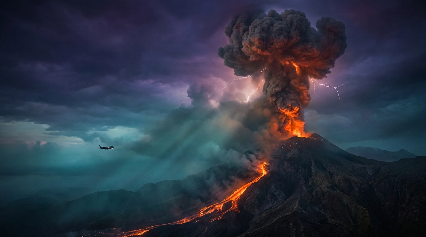
Multiple volcanoes across Central and South America generated ash clouds requiring aviation advisories within the last 24 hours. In Ecuador, Sangay volcano produced an ash column reaching 6,100 meters (20,000 feet) above sea level according to reports issued at 19:00 UTC on May 24, representing the highest plume recorded during this monitoring period and threatening trans-Andean flight routes. Guatemala’s Fuego volcano, one of the most active systems in Central America, generated ash emissions reaching 4,600 meters (15,100 feet) late on May 24, with volcanic material drifting west-southwest from the summit crater toward populated areas in the Escuintla and Sacatepéquez departments.
Reventador, located approximately 100 kilometers east of Quito in Ecuador’s Amazonian foothills, produced an ash advisory at 03:45 UTC on May 25, with plumes detected at 4,300 meters (14,100 feet) altitude. This early morning activity marked the continuation of Reventador’s persistent explosive behavior that has characterized the volcano throughout 2026, with ash fall potentially affecting oil extraction infrastructure in the surrounding Oriente region. Meanwhile, Puracé volcano in southwestern Colombia generated an ash advisory early on May 25, though specific plume altitudes were not immediately quantified by the Colombian Geological Survey (SGC) monitoring networks.
How Do These Ash Heights Impact Aviation Safety?
Volcanic ash clouds pose catastrophic risks to commercial aviation, particularly when they reach cruising altitudes between 6,000 and 12,000 meters where jet aircraft operate. Sangay’s 6,100-meter ash column penetrates the lower flight levels used by regional turboprop aircraft and potentially affects jet routes depending on wind patterns, according to Volcanic Ash Advisory Center (VAAC) Washington bulletins. When ash particles are ingested into jet engines, they can melt and resolidify on turbine blades, causing engine flameout and potential power loss that requires immediate emergency descent procedures.
Fuego’s 4,600-meter plume and Reventador’s 4,300-meter emissions primarily threaten arrival and departure corridors near Guatemala City and Quito international airports, respectively. These altitudes correspond to standard approach paths and holding patterns, requiring pilots to execute significant route deviations to avoid contamination. The Smithsonian Global Volcanism Program notes that even thinly dispersed ash invisible to radar can cause abrasion to windshields and airframe surfaces, necessitating groundings until atmospheric dispersal models confirm safe flight paths and satellite observations indicate clear airspace.
What Is the Current Status of Other Monitored Volcanoes?
While ash advisories dominated the Central and South American volcanic landscape today, global monitoring networks tracked persistent thermal anomalies and seismicity at several additional systems. On Russia’s Kamchatka Peninsula, Shiveluch volcano continued extruding viscous lava into its dome complex, generating periodic ash plumes and maintaining an Orange alert level due to the potential for pyroclastic flows that could affect the Klyuchi Valley region. In Indonesia, both Ibu on Halmahera Island and Dukono maintained their long-running eruptive sequences characterized by continuous low-level ash venting and crater glow visible at night, with alert levels remaining at SIAGA (Level III) and WASPADA (Level II) respectively according to the Indonesian Center for Volcanology and Geological Hazard Mitigation (CVGHM).
The Philippine archipelago also showed sustained volcanic unrest, with Mayon Volcano in Albay province displaying lava dome growth and degassing within its summit crater, prompting PHIVOLCS to maintain Alert Level 2 restrictions prohibiting entry to the 6-kilometer permanent danger zone. Meanwhile, Canlaon Volcano on Negros Island recorded volcanic earthquakes and ground deformation, remaining under Alert Level 1 as authorities warned against sudden phreatic explosions that could occur without precursor warning. These persistent activity patterns reflect the ongoing tectonic processes along the Pacific Ring of Fire, where subduction of oceanic lithosphere generates the magma driving these hazardous but geologically critical systems.
Volcanic Activity Summary Table
| Volcano | Location | Event Type | Alert Level |
|---|---|---|---|
| Sangay | Ecuador | Ash Advisory | Aviation Alert |
| Fuego | Guatemala | Ash Advisory | Aviation Alert |
| Reventador | Ecuador | Ash Advisory | Aviation Alert |
| Puracé | Colombia | Ash Advisory | Not Specified |
| Shiveluch | Russia (Kamchatka) | Dome Growth | Orange |
| Ibu | Indonesia (Halmahera) | Strombolian Eruption | Level III (SIAGA) |
| Mayon | Philippines (Luzon) | Lava Dome Activity | Alert Level 2 |
| Canlaon | Philippines (Negros) | Volcanic Unrest | Alert Level 1 |
| Dukono | Indonesia (Halmahera) | Continuous Ash | Level II (WASPADA) |
Data compiled from Smithsonian Global Volcanism Program, USGS Volcano Hazards Program, and local monitoring agencies including IG-EPN (Ecuador), INSIVUMEH (Guatemala), and SGC (Colombia). Alert levels reflect the most recent available status as of May 25, 2026.
Frequently Asked Questions
Is it safe to fly to Guatemala City or Quito with active ash advisories?
Commercial flights to Guatemala City (La Aurora International) and Quito (Mariscal Sucre International) may experience delays or diversions when volcanoes like Fuego and Reventador emit ash into approach corridors. While airports typically remain open during moderate ash fall, airlines will cancel or reroute flights if ash concentrations exceed safety thresholds. Passengers should verify flight status directly with carriers and consider that volcanic ash can cause abrasive damage to aircraft engines and external surfaces even when visibility appears normal.
How long do volcanic ash particles remain dangerous in the atmosphere?
Volcanic ash can remain hazardous to aviation for hours to weeks depending on eruption intensity, column height, and prevailing wind patterns at stratospheric levels. Fine ash particles less than 2 millimeters in diameter can travel hundreds of kilometers from the source volcano, remaining suspended in the atmosphere where jet aircraft operate. According to the USGS, these particles consist of sharp, glassy fragments and crystalline minerals that melt inside jet engines operating at high temperatures, potentially causing compressor stall and engine failure until the ash completely disperses or settles.
What should residents do when an ash advisory is issued for their area?
Communities near active volcanoes should prepare for ashfall by sealing windows and doors, disconnecting downspouts from rainwater collection systems to prevent contamination, and wearing N95 respirators or damp cloth masks when outdoors. Volcanic ash is abrasive, electrically conductive, and can contaminate water supplies, damage vegetation, and cause respiratory irritation in vulnerable populations. Residents should avoid driving if possible, as ash accumulation on roadways reduces traction and can damage vehicle engines, while also clearing roofs periodically to prevent structural collapse under heavy ash loads.
Track this event live on the map!
Download GeoShake and get instant earthquake alerts.
Download GeoShake