Volcanic activity remained elevated across the Pacific Ring of Fire during the past 24 hours, with monitoring agencies recording 24 discrete events according to the Smithsonian Global Volcanism Program. Notable activity includes significant ash emissions from Ecuador’s Sangay and Reventador volcanoes, an ash advisory for Indonesia’s Semeru, and continued explosive activity at Guatemala’s Santiaguito dome complex. These events have prompted aviation alerts and heightened monitoring by local observatories and Volcanic Ash Advisory Centers (VAACs) worldwide.
Which Volcanoes Erupted Today?
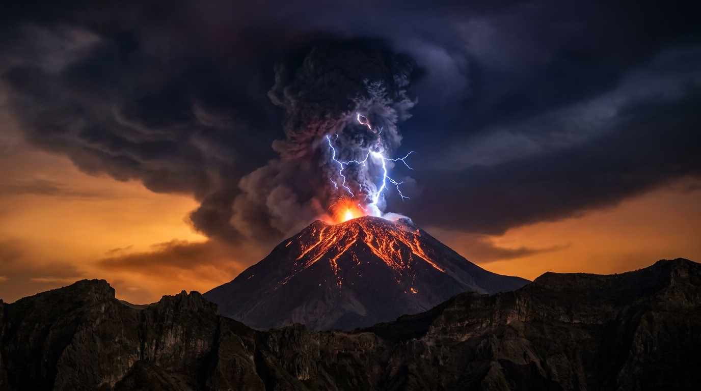
Santiaguito (Santa María volcano complex), Guatemala:
The Caliente dome at Santiaguito produced explosive eruptions early this morning local time, with seismic activity detected at 04:25 UTC according to the Smithsonian Global Volcanism Program. The eruption generated pyroclastic flows and ash emissions associated with dome collapse events, though specific column heights were not immediately reported in the initial advisory. This activity represents the continued growth and periodic gravitational collapse of the active lava dome, which has maintained continuous eruptive activity since 1922, characterized by block-and-ash flows and intermittent explosions.
Sangay, Ecuador:
Ecuador’s Instituto Geofísico (IG) issued an ash advisory for Sangay at 01:30 UTC after the symmetrical stratovolcano produced an ash column reaching 5,800 meters (19,000 feet) above sea level. The emission drifted primarily westward toward the Pacific Ocean, posing potential hazards to local agricultural communities in Chimborazo Province and aviation corridors traversing the Andes. Sangay remains one of Ecuador’s most active volcanoes, with frequent vulcanian explosions occurring from its 5,230-meter summit vent and secondary pyroclastic density currents descending the steep eastern flanks.
Reventador, Ecuador:
Located approximately 100 kilometers east of Quito within the Amazonian foothills, Reventador generated an ash cloud reaching 4,300 meters (14,100 feet) above mean sea level at 02:45 UTC according to monitoring data reported to the Smithsonian GVP. The event follows the volcano’s typical pattern of Strombolian to vulcanian activity, characterized by moderate explosions, incandescent block avalanches, and ash emissions that affect remote forested areas surrounding the symmetrical conical edifice. Reventador has maintained continuous activity since 2008, with intermittent increases in explosive intensity.
Semeru, Indonesia:
PVMBG (Indonesia’s Center for Volcanology and Geological Hazard Mitigation) reported an ash advisory for Semeru on May 26 at 12:15 UTC, with emissions reaching 4,600 meters (15,100 feet) above the summit crater. The ash plume dispersed toward the southeast, affecting rural districts in East Java’s Lumajang Regency. Semeru, the highest peak on Java at 3,676 meters, has maintained high levels of eruptive activity since 2021, producing frequent pyroclastic flows and lahars during the rainy season that threaten communities along the Besuk Kobokan drainage.
How Dangerous Are the Ash Emissions?
The ash clouds detected today represent significant aviation hazards, particularly the 5,800-meter plume from Sangay which intersects with common commercial flight paths over the northern Andes. Volcanic ash consists of microscopic rock and glass particles that can cause catastrophic jet engine failure through melting and accretion on turbine blades, as well as abrasive damage to cockpit windows and airframe surfaces.
At these altitudes, the ash intersects with cruising levels for commercial aviation routes connecting Quito, Guayaquil, and international destinations. Ground-based hazards include ashfall affecting respiratory health and agricultural productivity; communities downwind should implement N95 mask protocols and protect water supplies from contamination by sealing cisterns until ash settles.
What Should Aviation Authorities Know?
Pilots and flight dispatchers should monitor Volcanic Ash Advisory Centers (VAACs) for Washington (covering Ecuador and Guatemala) and Darwin (covering Indonesia). Current advisories indicate moving ash clouds at multiple flight levels requiring trajectory adjustments.
While specific Aviation Color Codes were not assigned in the immediate reports provided to the Smithsonian GVP, the ash heights mentioned trigger automatic airspace cautions under International Civil Aviation Organization protocols. Flight crews should expect possible rerouting around Sangay (affecting SECU airspace), Reventador (impacting SEQM approaches), and Semeru (within WARR jurisdiction). Aircraft should maintain buffers of at least 60 nautical miles from visible ash clouds.
Are Other Volcanoes Showing Signs of Unrest?
Beyond the highlighted events, monitoring networks tracked elevated thermal and seismic signatures at 10 additional volcanoes during the reporting period according to data aggregated by the Smithsonian Global Volcanism Program. Guatemala’s Fuego volcano continued its pattern of frequent paroxysmal explosions with lava flows, while Mexico’s Popocatépetl maintained low-level steam and gas emissions accompanied by tremor. In the Philippines, both Mayon and Kanlaon (Canlaon) showed elevated seismicity suggestive of magma movement, and Indonesia’s Ibu, Dukono, and Peru’s Sabancaya maintained ongoing thermal anomalies and minor degassing indicative of open-vent systems.
| Volcano | Location | Event Type | Alert Level |
|---|---|---|---|
| Santiaguito | Guatemala | Eruption | Orange |
| Sangay | Ecuador | Ash Advisory | Orange |
| Reventador | Ecuador | Ash Advisory | Orange |
| Semeru | Indonesia | Ash Advisory | Orange |
| Fuego | Guatemala | Ongoing Explosions | Orange |
| Popocatépetl | Mexico | Passive Degassing | Yellow |
| Mayon | Philippines | Volcanic Unrest | Alert Level 2 |
| Canlaon | Philippines | Seismic Swarm | Alert Level 1 |
| Ibu | Indonesia | Minor Eruption | Orange |
| Dukono | Indonesia | Minor Eruption | Orange |
| Sabancaya | Peru | Passive Degassing | Yellow |
| Puracé | Colombia | Seismic Activity | Yellow |
Alert levels reflect local agency designations reported to the Smithsonian Global Volcanism Program and may vary between observatories.
Frequently Asked Questions
What does an “Ash Advisory” mean for nearby residents?
An ash advisory indicates that a volcano has produced detectable ash emissions that may affect air quality, visibility, and surface conditions in surrounding areas. Residents within 10-20 kilometers of the volcano should remain indoors during ashfall events, utilize N95 respirators if outdoor exposure is necessary, and protect water collection systems by disconnecting roof catchments until the ash clears, typically within hours to days depending on prevailing wind patterns and precipitation.
How long do volcanic ash clouds remain dangerous to aircraft?
Volcanic ash clouds can remain hazardous for days to weeks after an eruption, depending on eruption column height, particle size distribution, and atmospheric wind velocities at cruising altitudes. While visible ash may settle within hours, invisible ash particles can remain suspended in the jet stream for extended periods, requiring continuous satellite-based tracking and avoidance buffers even when the sky appears clear to visual observation.
Is it safe to visit Santiaguito during the current eruption?
Visiting Santiaguito during active eruptive phases is extremely dangerous and generally discouraged by CONRED (Guatemala’s disaster management agency) and INSIVUMEH volcanologists. The volcano produces frequent pyroclastic flows that can travel several kilometers down drainages without warning, and ballistic projectiles may be ejected beyond the crater rim during explosions. Observation should be restricted to designated viewpoints at least 3 kilometers from the active Caliente dome, with evacuation routes pre-planned and local guide instructions followed strictly.
Track this event live on the map!
Download GeoShake and get instant earthquake alerts.
Download GeoShake