Volcanic activity worldwide maintained elevated levels throughout the past 24 hours, with the Smithsonian Global Volcanism Program documenting 25 distinct eruptive events across sixteen active volcanic systems as of June 1, 2026. The period was characterized by multiple high-altitude ash emissions requiring aviation advisories, particularly from stratovolcanoes positioned along the Pacific Ring of Fire. Monitoring agencies issued critical safety notifications for ash plumes reaching altitudes between 4,300 and 7,300 meters, potentially impacting commercial flight corridors across the Americas and Southeast Asia.
Which Volcanoes Erupted Today?
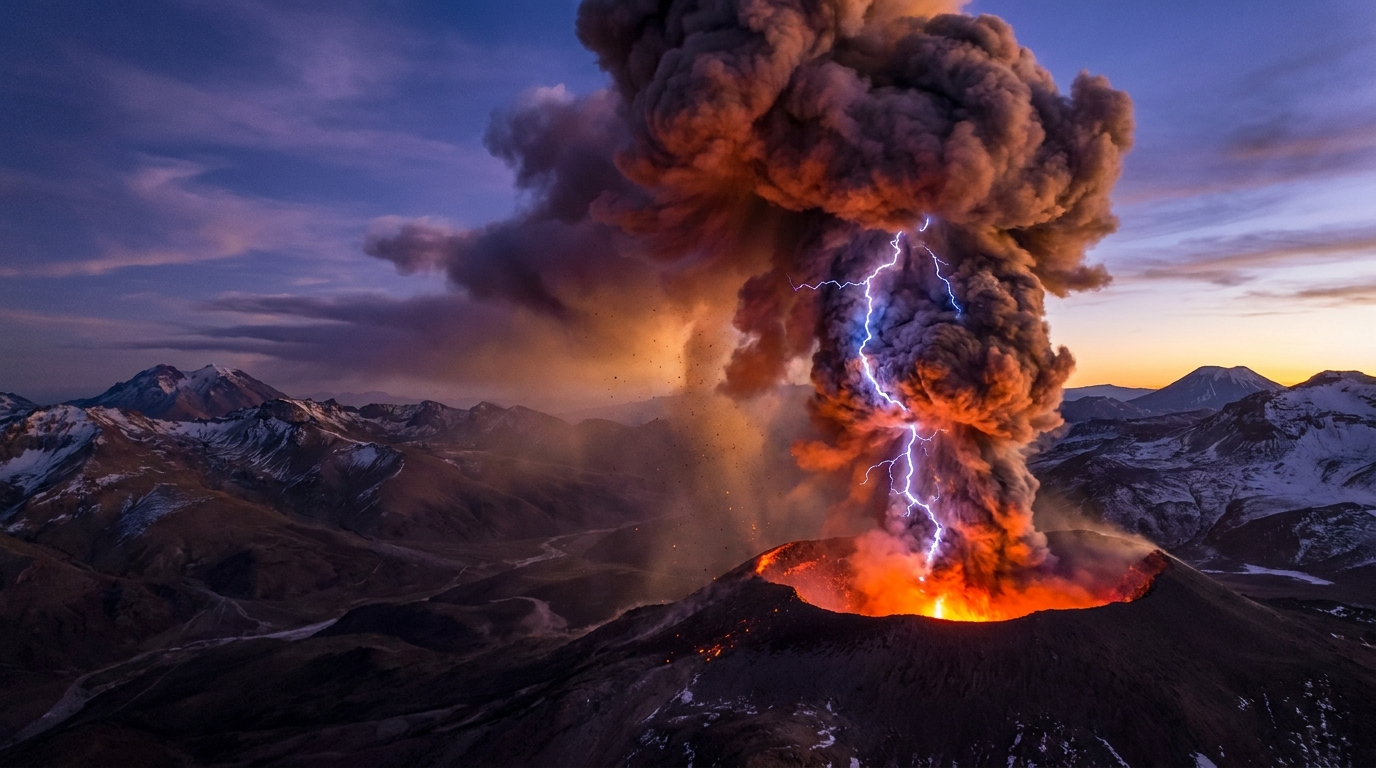
Santiaguito volcano in Guatemala generated significant explosive activity during this reporting period, producing both pyroclastic flows and sustained ash emissions according to data compiled by the Smithsonian Global Volcanism Program. The lava dome complex, located within the Santa María volcanic system, generated ash plumes rising to approximately 4,300 meters (14,100 feet) above sea level, with major eruptive pulses detected at 17:30 UTC on May 31 and continuing observations through 21:00 UTC.
Peru’s Sabancaya volcano maintained its persistent explosive character, emitting ash clouds that reached the highest altitude recorded in this cycle at 7,300 meters (23,900 feet) above sea level. The Buenos Aires Volcanic Ash Advisory Center issued navigation warnings following the 21:15 UTC detection on May 31, as the stratovolcano continued its ongoing period of unrest approximately 70 kilometers northwest of Arequipa.
Mexico’s Popocatépetl generated substantial ash emissions detected at 00:45 UTC on June 1, with plumes ascending to 6,100 meters (20,000 feet) according to reports from the Washington Volcanic Ash Advisory Center. Simultaneously, Indonesia’s Semeru volcano produced ash advisories at 00:30 UTC June 1, with volcanic ash reaching 4,600 meters (15,100 feet) above the summit crater in East Java, reported by the Darwin VAAC.
Additional volcanic systems showing detectable activity include Mayon in the Philippines, Fuego and Pacaya in Guatemala, Sakurajima in Japan, and Puracé in Colombia. The Central Bismarck Sea region also exhibited submarine volcanic unrest, though specific emission parameters were not quantified in available monitoring data.
How High Did the Ash Clouds Rise?
The vertical extent of volcanic ash columns serves as a primary indicator of eruption intensity and aviation hazard classification. Sabancaya produced the most vertically extensive plume at 7,300 meters, penetrating the upper troposphere and potentially affecting long-haul flight routes traversing South American airspace. This altitude places the ash cloud directly within cruising altitudes utilized by commercial jet aircraft traveling between 24,000 and 40,000 feet, necessitating immediate flight path modifications for southbound Pacific routes.
Popocatépetl’s ash column reached 6,100 meters, positioning the volcanic debris within the mid-to-upper troposphere where prevailing wind patterns could transport particulate matter toward the Gulf of Mexico or Pacific coastlines depending on meteorological conditions. Semeru and Santiaguito generated lower-altitude emissions at 4,600 meters and 4,300 meters respectively, though these heights still intersect with approach and departure corridors for regional airports near Surabaya, Guatemala City, and Quetzaltenango.
What Should Aviation Know About Today’s Activity?
Pilots and flight dispatchers should monitor Volcanic Ash Advisory Center (VAAC) warnings from Washington, Buenos Aires, and Darwin, which issued advisories corresponding to today’s active volcanoes. The high-altitude nature of Sabancaya’s emissions requires particular attention for trans-Andean routes between Santiago, Lima, and Bogotá, as volcanic glass particles can cause catastrophic engine failure when ingested by jet turbines operating at high temperatures. NOTAMs (Notices to Airmen) remain active for airspace surrounding Popocatépetl, with ash dispersal models indicating potential northeastward drift toward Puebla and Tlaxcala based on prevailing wind patterns at 6,000 meters.
Aircraft operating near Central America should note simultaneous activity from both Santiaguito and Fuego in Guatemala, creating complex airspace management challenges for regional carriers serving Guatemala City. The Washington VAAC continues to track ash cloud movement using geostationary satellite imagery and atmospheric dispersion models, updating advisories every six hours or upon detection of significant changes in eruption characteristics.
Are There Any Evacuation Orders in Place?
While volcanic ash advisories indicate airborne hazards rather than immediate ground-based dangers, local monitoring agencies maintain elevated alert statuses for multiple systems. Indonesia’s Center for Volcanology and Geological Hazard Mitigation (PVMBG) typically maintains Semeru at Level III (Siaga) status during such ash emissions, restricting access within a 5-kilometer radius of the summit crater and warning of potential pyroclastic flows in drainages.
Mexico’s National Disaster Prevention Centre (CENAPRED) maintains Popocatépetl at Yellow Alert Phase 2, advising residents of surrounding Puebla and State of Mexico municipalities to avoid approaching the crater within 12 kilometers. No immediate evacuation orders were reported for Santiaguito or Sabancaya, though the Instituto Geofísico del Perú (IGP) continues vigilant monitoring of lahar generation in the Colca Canyon region.
Global Activity Summary Table
| Volcano | Location | Event Type | Alert Level |
|---|---|---|---|
| Sabancaya | Peru | Ash Advisory | Orange (Not Specified) |
| Popocatépetl | Mexico | Ash Advisory | Yellow Phase 2 |
| Semeru | Indonesia | Ash Advisory | Level III (Siaga) |
| Santiaguito | Guatemala | Eruption & Ash | Not Specified |
| Mayon | Philippines | Volcanic Activity | Alert Level 2 |
| Fuego | Guatemala | Volcanic Activity | Not Specified |
| Sakurajima | Japan | Volcanic Activity | Level 3 |
| Puracé | Colombia | Volcanic Activity | Not Specified |
| Dukono | Indonesia | Volcanic Activity | Not Specified |
| Ibu | Indonesia | Volcanic Activity | Not Specified |
| Sangay | Ecuador | Volcanic Activity | Not Specified |
| Telica | Nicaragua | Volcanic Activity | Not Specified |
| Reventador | Ecuador | Volcanic Activity | Not Specified |
| Central Bismarck Sea | Papua New Guinea | Submarine Activity | Not Specified |
Data sources: Smithsonian Global Volcanism Program, USGS, local monitoring agencies (CENAPRED, PVMBG, IGP, INSIVUMEH)
Frequently Asked Questions
What causes volcanic ash to reach such extreme altitudes?
Explosive volcanic eruptions propel ash into the atmosphere through rapid gas expansion and the thermal buoyancy of the eruption column. When magma contains high volatile content or interacts with groundwater, the resulting decompression generates powerful updrafts capable of carrying particulate matter into the upper troposphere. The recorded height of 7,300 meters at Sabancaya indicates significant energy release, though these plumes remain within the troposphere where ash eventually settles rather than remaining suspended for extended periods.
How long do volcanic ash advisories typically remain active?
Volcanic Ash Advisory Centers maintain active warnings until satellite observations and ground-based radar confirm that ash clouds have dispersed below hazardous concentrations or moved outside monitored airspace. These advisories typically update every six hours, with expiration times ranging from twelve to twenty-four hours depending on eruption persistence and atmospheric wind speeds. Pilots should treat volcanic ash advisories as dynamic conditions requiring continuous monitoring rather than fixed-time restrictions.
Can today’s volcanic activity affect global climate patterns?
Individual explosive events like those recorded at Semeru and Popocatépetl generally produce localized atmospheric effects unless sulfur dioxide emissions exceed several million tons and reach the stratosphere. The ash heights reported today remain primarily within the troposphere, where precipitation processes typically remove particulate matter within days to weeks. However, cumulative emissions from the sixteen active systems could contribute to regional atmospheric cooling if sustained eruptive phases continue throughout the coming months.
Track this event live on the map!
Download GeoShake and get instant earthquake alerts.
Download GeoShake