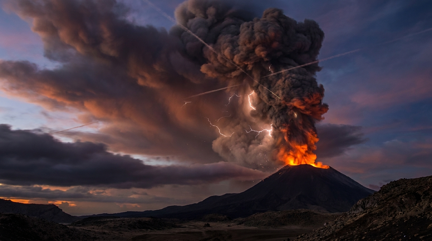
Global volcanic surveillance networks recorded 28 discrete eruptive events across 15 active volcanic systems during the past 24 hours, according to the Smithsonian Global Volcanism Program. Notable activity includes significant high-altitude ash emissions from Russia’s Shiveluch volcano reaching 6,700 meters above sea level, alongside substantial ash advisories for Mexico’s Popocatépetl and Indonesia’s Semeru. Volcanic Ash Advisory Centers (VAACs) in Anchorage, Washington, and Darwin issued multiple warnings as these plumes intersected with commercial aviation corridors.
Which Volcanoes Produced High-Altitude Ash Today?
Four volcanic systems generated ash columns exceeding 4,500 meters, triggering international aviation alerts and highlighting elevated explosive behavior across the Pacific Ring of Fire.
Shiveluch, Russia
Located on the Kamchatka Peninsula, Shiveluch produced the highest ash cloud of the reporting period, reaching 6,700 meters (approximately 22,000 feet) above sea level according to VAAC Anchorage. The event represents ongoing dome-building activity at the stratovolcano, where viscous lava accumulation periodically triggers vulcanian explosions capable of injecting ash into the upper troposphere. Prevailing wind patterns carried the ash plume eastward over the Bering Sea, posing potential routing challenges for trans-Pacific flights.
Popocatépetl, Mexico
Mexico’s most active volcano generated an ash advisory after emitting a plume to 6,100 meters (20,000 feet) altitude, as reported by VAAC Washington. The stratovolcano, situated 70 kilometers southeast of Mexico City, exhibited sustained tremor associated with gas-and-ash exhalations. Ashfall was reported in communities within the states of Puebla and Morelos, though the primary hazard centered on aviation corridors serving Mexico City International Airport.
Central Bismarck Sea, Papua New Guinea
Activity within the Central Bismarck Sea volcanic complex produced an ash column reaching 4,900 meters (16,000 feet), according to VAAC Darwin. This submarine and island arc system includes historically active vents such as Garove and Ritter Island. The ash emission suggests either renewed island-based activity or a submarine eruption breaking the surface, requiring ongoing maritime and aerial surveillance in the Bismarck Archipelago region.
Semeru, Indonesia
East Java’s highest peak emitted ash to 4,600 meters (15,100 feet) altitude, prompting advisories from VAAC Darwin. The volcano, also known as Mahameru, produced pyroclastic density currents and ash clouds resulting from dome collapse events at the Jonggring Saloko crater rim. Indonesian authorities maintain exclusion zones around the summit due to the persistent threat of sudden explosions and lahar generation during rainfall.
What Other Volcanic Systems Showed Significant Activity?
Beyond the high-altitude ash producers, eleven additional volcanoes exhibited measurable unrest or eruptive behavior during the reporting period.
Fuego, Guatemala
The Volcán de Fuego generated explosive activity characterized by strombolian eruptions and lava fountain production, according to local monitoring agencies. Ash plumes drifted westward toward the Pacific coast, while incandescent material rolled down the volcano’s steep flanks toward barrancas. This activity represents the typical basaltic-andesite effusive-explosive cycle that has characterized Fuego’s behavior for decades.
Sabancaya, Peru
Peru’s Instituto Geofísico del Perú (IGP) reported continued degassing and minor ash emissions from Sabancaya, located 60 kilometers northwest of Arequipa. Seismic networks detected hybrid earthquakes indicating magma movement, though surface activity remained confined to vapor plumes with intermittent light ash content.
Mayon, Philippines
Philippine Institute of Volcanology and Seismology (PHIVOLCS) monitors recorded lava dome growth and occasional rockfall events at Mayon. The symmetrical stratovolcano maintained Alert Level 2, indicating increased unrest and the potential for sudden explosions or dome collapse.
Additional Indonesian Activity
The archipelago sustained multiple simultaneous eruptions. Ibu in North Maluku generated explosive bursts and ash clouds reaching 2,000 meters. Marapi in West Sumatra produced smaller ash emissions following recent deadly eruptions. Dukono on Halmahera maintained continuous ash venting, while Reventador in Ecuador contributed basaltic-andesite ash to the Amazonian atmosphere.
Aoba, Vanuatu and Puracé, Colombia
Aoba (Ambae) exhibited renewed unrest with gas-and-steam emissions from Lake Manaro, while Puracé and the Cerro Negro de Mayasque volcanic complex in Colombia registered elevated seismicity and deformation suggestive of hydrothermal or magmatic intrusion.
How Do These Ash Altitudes Impact Aviation Safety?
Commercial aircraft typically cruise at altitudes between 9,000 and 12,000 meters (30,000–40,000 feet), placing today’s 6,000–6,700-meter ash clouds directly within critical flight levels during ascent and descent phases. Volcanic ash poses catastrophic risks to jet engines, where silica particles melt in combustion chambers and solidify on turbine blades, causing engine flameout.
VAACs utilize satellite infrared detection and dispersion modeling to forecast ash cloud movement. Pilots rely on these advisories to navigate around concentrations exceeding 4 micrograms per cubic meter. The 6,700-meter Shiveluch plume intersected North Pacific tracks used by transpacific routes, while Popocatépetl’s emissions affected busy Central American corridors. Operators must maintain diversion fuel reserves when transiting regions with multiple concurrent ash advisories.
Current Global Activity Summary
| Volcano | Location | Event Type | Alert Level |
|---|---|---|---|
| Shiveluch | Russia | Ash Advisory | Not Specified |
| Popocatépetl | Mexico | Ash Advisory | Not Specified |
| Central Bismarck Sea | Papua New Guinea | Ash Advisory | Not Specified |
| Semeru | Indonesia | Ash Advisory | Not Specified |
| Fuego | Guatemala | Strombolian Eruption | Not Specified |
| Sabancaya | Peru | Ash Emission | Not Specified |
| Aoba | Vanuatu | Volcanic Unrest | Not Specified |
| Mayon | Philippines | Dome Growth | Not Specified |
| Ibu | Indonesia | Explosive Eruption | Not Specified |
| Puracé | Colombia | Seismic Swarm | Not Specified |
| Marapi | Indonesia | Ash Explosion | Not Specified |
| Reventador | Ecuador | Ash Emission | Not Specified |
| Dukono | Indonesia | Continuous Ash | Not Specified |
Frequently Asked Questions
How high must volcanic ash reach to threaten commercial aircraft?
Volcanic ash presents hazards at any altitude, but becomes critical when reaching above 3,000 meters (10,000 feet) where most commercial traffic operates. Today’s reports of 6,000–6,700 meters place these plumes within the upper troposphere, directly intersecting cruising altitudes on trans-Pacific and Central American routes. Jet engines can suffer complete failure within minutes of ash ingestion, and aircraft windshields may become abraded and opaque, necessitating strict avoidance regardless of concentration levels.
What is the difference between an ash advisory and an eruption alert?
An ash advisory is issued specifically by Volcanic Ash Advisory Centers to warn aviation of airborne ash hazards, specifying cloud height, movement, and concentration. An eruption alert (or volcano alert level) is issued by local geological observatories to indicate the volcano’s status, ranging from “Normal” to “Warning,” based on seismicity, ground deformation, and observed explosions. A volcano may generate an aviation ash advisory without a change in local alert level if the ash remains aloft and poses no immediate ground hazard.
Should residents near these volcanoes prepare for evacuation?
Immediate evacuation decisions depend on local alert levels, pyroclastic flow risks, and ashfall accumulation rather than aviation advisories alone. While today’s high-altitude ash primarily threatens aviation, ground communities near Popocatépetl should remain prepared for rapid alert level changes and ashfall protection. Remote volcanoes like Shiveluch pose minimal population risk despite high-altitude emissions. Residents within 10–15 kilometers of active Indonesian volcanoes (Semeru, Ibu, Marapi) should maintain emergency kits and monitor local authority instructions regarding lahar and pyroclastic flow hazards.
Track this event live on the map!
Download GeoShake and get instant earthquake alerts.
Download GeoShake