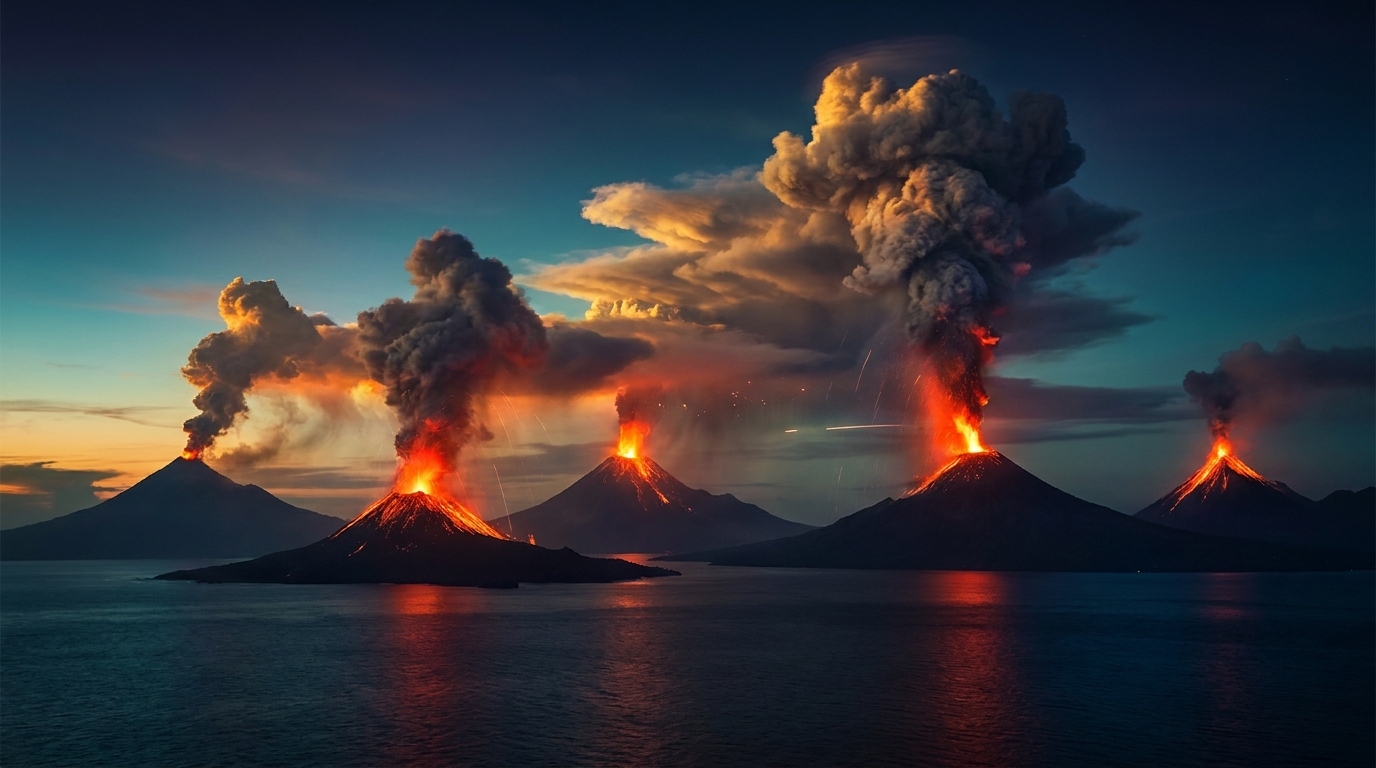
The past 24 hours have recorded significant volcanic unrest across the Pacific Ring of Fire and beyond, with monitoring agencies documenting 44 distinct volcanic events globally. According to the Smithsonian Global Volcanism Program, notable activity includes phreatic eruptions in the Philippines, ash emissions from Indonesia’s most active peaks, and continued lava dome growth in Central America. Local monitoring agencies including PHIVOLCS, PVMBG, and USGS have issued advisories as several volcanoes exhibit heightened unrest requiring close observation.
Which Volcanoes Erupted Today?
Bulusan (Philippines) generated a phreatic eruption early this morning, producing a steam-driven explosion that sent an ash column approximately 500 meters above the crater. The Philippine Institute of Volcanology and Seismology (PHIVOLCS) reported that the event was likely triggered by the interaction of groundwater with hot magmatic materials beneath the summit. While no ashfall was reported in nearby communities, the eruption prompted temporary suspension of activities within the four-kilometer permanent danger zone.
Taal Volcano (Philippines) exhibited increased phreatic activity characterized by steam emissions reaching 1,200 meters high and weak explosions audible from the surrounding Batangas province. PHIVOLCS maintains Alert Level 2 over the volcano, indicating that magma has been intruding beneath the main crater and could trigger further explosions. Residents of Volcano Island and high-risk barangays in the towns of Agoncillo and Laurel remain under evacuation preparedness protocols.
Semeru (Indonesia) produced another vulcanian eruption typical of its current eruptive phase, ejecting ash clouds to an estimated altitude of 4,000 meters above sea level. The Pusat Vulkanologi dan Mitigasi Bencana Geologi (PVMBG) reported that pyroclastic flows traveled up to 2 kilometers down the southeast flank, though no casualties were reported. Seismic instruments detected 28 eruption earthquakes and 4 avalanches during the 24-hour observation period.
Sangay (Ecuador) continued its prolonged explosive activity with ash emissions drifting westward toward the Pacific Ocean. The Instituto Geofísico-Escuela Politécnica Nacional (IG-EPN) reported that the eruption column reached 6,000 meters above sea level, potentially affecting agricultural areas in the provinces of Chimborazo and Guayas depending on wind patterns. Strombolian activity at the summit crater produced incandescent material that rolled 500 meters down the southeastern flank.
Santiaguito (Guatemala) maintained its pattern of lava dome growth accompanied by periodic block-and-ash flows descending the eastern and southeastern flanks. The Instituto Nacional de Sismología, Vulcanología, Meteorología e Hidrología (INSIVUMEH) noted that the active Caliente dome continues to generate explosive episodes every few hours, sending ash plumes to 3,500 meters altitude that disperse toward the southwest.
What Do These Eruptions Mean for Aviation Safety?
Volcanic ash clouds pose catastrophic risks to jet aircraft engines, making continuous monitoring by Volcanic Ash Advisory Centers (VAAC) essential for global aviation. According to the USGS, the eruptions at Semeru and Sangay generated ash columns reaching flight levels between 10,000 and 20,000 feet, potentially intersecting with busy transpacific air routes. Pilots are advised to exercise extreme caution when operating near these volcanic centers, as ash clouds can travel hundreds of kilometers from their source and are difficult to detect on standard aircraft weather radar.
The Washington VAAC has issued advisories for Central American airspace due to activity at Fuego and Santiaguito, while the Darwin VAAC monitors Indonesian corridors affected by Dukono, Ibu, and Semeru. Aircraft encountering volcanic ash may experience engine flameout, abrasion of windshields and flight surfaces, and contamination of fuel and lubrication systems. Airlines are recommended to reroute flights at least 20 nautical miles from identified ash clouds, though dynamic atmospheric conditions may require greater separation distances.
How Are Local Monitoring Agencies Responding?
Civil defense agencies across multiple nations have activated contingency protocols as volcanic unrest intensifies. In the Philippines, PHIVOLCS maintains close coordination with the Office of Civil Defense to prepare for potential escalation at Bulusan and Taal, including pre-positioning relief goods and conducting community drills. Indonesian authorities have restricted access to the Semeru danger zone while maintaining the Level III (Siaga) alert status, which prohibits any human activity within 5 kilometers of the Jongring Seloko crater.
Ecuador’s Risk Management Secretariat has advised residents in ashfall-prone areas to protect water sources and livestock as Sangay continues its vigorous output. According to the Smithsonian Global Volcanism Program, the current global volcanic activity level remains within expected parameters for the Ring of Fire, though the concentration of simultaneous eruptions requires enhanced international monitoring cooperation. Ground-based deformation networks and satellite-based interferometric synthetic aperture radar (InSAR) continue tracking magma movement beneath these restless volcanoes.
Comparison of Currently Active Volcanoes
| Volcano | Location | Event Type | Alert Level |
|---|---|---|---|
| Bulusan | Philippines | Phreatic Eruption | Alert Level 1 |
| Taal | Philippines | Phreatic Activity | Alert Level 2 |
| Mayon | Philippines | Lava Flows | Alert Level 2 |
| Kanlaon | Philippines | Volcanic Unrest | Alert Level 1 |
| Semeru | Indonesia | Vulcanian Eruption | Level III (Siaga) |
| Dukono | Indonesia | Strombolian | Level II (Waspada) |
| Ibu | Indonesia | Explosive Eruption | Level III (Siaga) |
| Lewotolok | Indonesia | Explosive Eruption | Level III (Siaga) |
| Lewotobi | Indonesia | Explosive Eruption | Level III (Siaga) |
| Marapi | Indonesia | Strombolian | Level II (Waspada) |
| Sangay | Ecuador | Strombolian | Orange |
| Reventador | Ecuador | Strombolian | Orange |
| Santiaguito | Guatemala | Lava Dome Growth | Orange |
| Fuego | Guatemala | Strombolian | Orange |
| Popocatépetl | Mexico | Strombolian | Yellow |
| Sabancaya | Peru | Vulcanian | Orange |
| Puracé | Colombia | Seismic Swarm | Yellow |
| Shiveluch | Russia | Explosive | Orange |
| Bezymianny | Russia | Dome Growth | Yellow |
| Sakurajima | Japan | Explosive | Level 3 |
| Kīlauea | USA (Hawaii) | Effusive | Advisory |
| Shishaldin | USA (Alaska) | Explosive | Watch |
| Great Sitkin | USA (Alaska) | Effusive | Advisory |
| Kupreanof | USA (Alaska) | Volcanic Unrest | Advisory |
| Central Bismarck Sea | Papua New Guinea | Submarine Activity | Unassigned |
Frequently Asked Questions
Is volcanic ash dangerous to human health?
Yes, volcanic ash presents significant respiratory hazards due to its composition of microscopic rock, mineral, and glass particles. According to the USGS, inhaling ash can trigger asthma attacks, bronchitis, and other respiratory issues, particularly in children, the elderly, and individuals with pre-existing lung conditions. Residents in ashfall areas should remain indoors with windows closed, use N95 respirators if outdoor exposure is unavoidable, and avoid driving to prevent vehicle damage and accidents on slippery roads.
How do scientists predict volcanic eruptions?
Scientists employ multi-parameter monitoring networks including seismometers to detect magma movement, GPS stations to measure ground inflation, gas analyzers to measure sulfur dioxide emissions, and thermal cameras to detect heat anomalies. While these techniques cannot predict exact eruption times with hour-precision, they provide crucial days to weeks of warning before major events. According to the Smithsonian Global Volcanism Program, successful evacuations at Pinatubo in 1991 and recent events in the Caribbean demonstrate the effectiveness of modern volcano monitoring when combined with rapid civil defense response.
What is the Aviation Color Code Orange?
The Aviation Color Code Orange indicates that a volcano is exhibiting heightened unrest with an increased likelihood of eruption, or that an eruption is already underway with no or minor ash emissions. According to USGS Alaska Volcano Observatory protocols, this level signifies that volcanic activity has escalated beyond background levels and poses potential hazards to aircraft in the vicinity. Pilots should avoid flying near the volcano and report any observed ash clouds to air traffic control, as conditions can deteriorate rapidly to Red status with significant ash emissions.
Track this event live on the map!
Download GeoShake and get instant earthquake alerts.
Download GeoShake