
At just 5.5 kilometers beneath the Mediterranean seabed—shallower than the cruising altitude of many hot air balloons—a magnitude 4.8 earthquake jolted Turkey’s southwestern coast on April 8, sending subtle but perceptible vibrations through the resort province of Muğla. The tremor struck at 11:35 UTC near the coastal town of Akdeniz, according to USGS data, arriving as the latest exclamation point in a week-long seismic conversation between the African and Aegean tectonic plates. For residents and seismologists alike, the event serves as a reminder that this sun-drenched stretch of coastline sits atop one of the Mediterranean’s most geologically restless intersections.
Why Is This Region So Prone to Shaking?
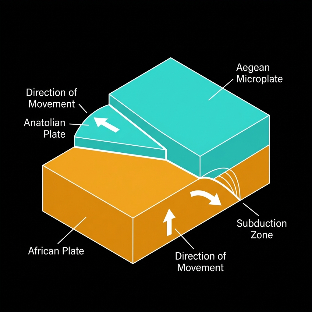
The Aegean Sea is a tectonic crossroads where three major plates engage in a slow-motion collision that has sculpted the region’s mountainous topography and island chains. Here, the northward-moving African Plate dives beneath the Aegean Microplate in a process called subduction, while the Anatolian Plate escapes westward like a wedge squeezed between the Arabian and Eurasian plates. This complex choreography creates extensional forces that pull the crust apart, generating normal faults capable of significant earthquakes.
Historical records confirm the region’s destructive potential. Seismologists classify this area as capable of producing magnitude 6+ events, a threshold crossed nine times in the past four decades within 200 kilometers of Wednesday’s tremor. The 2013 M6.6 earthquake near Kíssamos, Greece, struck just 63 kilometers away, while the 2006 M6.7 event near Kýthira claimed lives and damaged infrastructure across the southern Aegean. These are not ancient historical footnotes but recent demonstrations of accumulated tectonic stress releasing violently near populated coastlines.
What Does Such a Shallow Depth Mean for Local Residents?
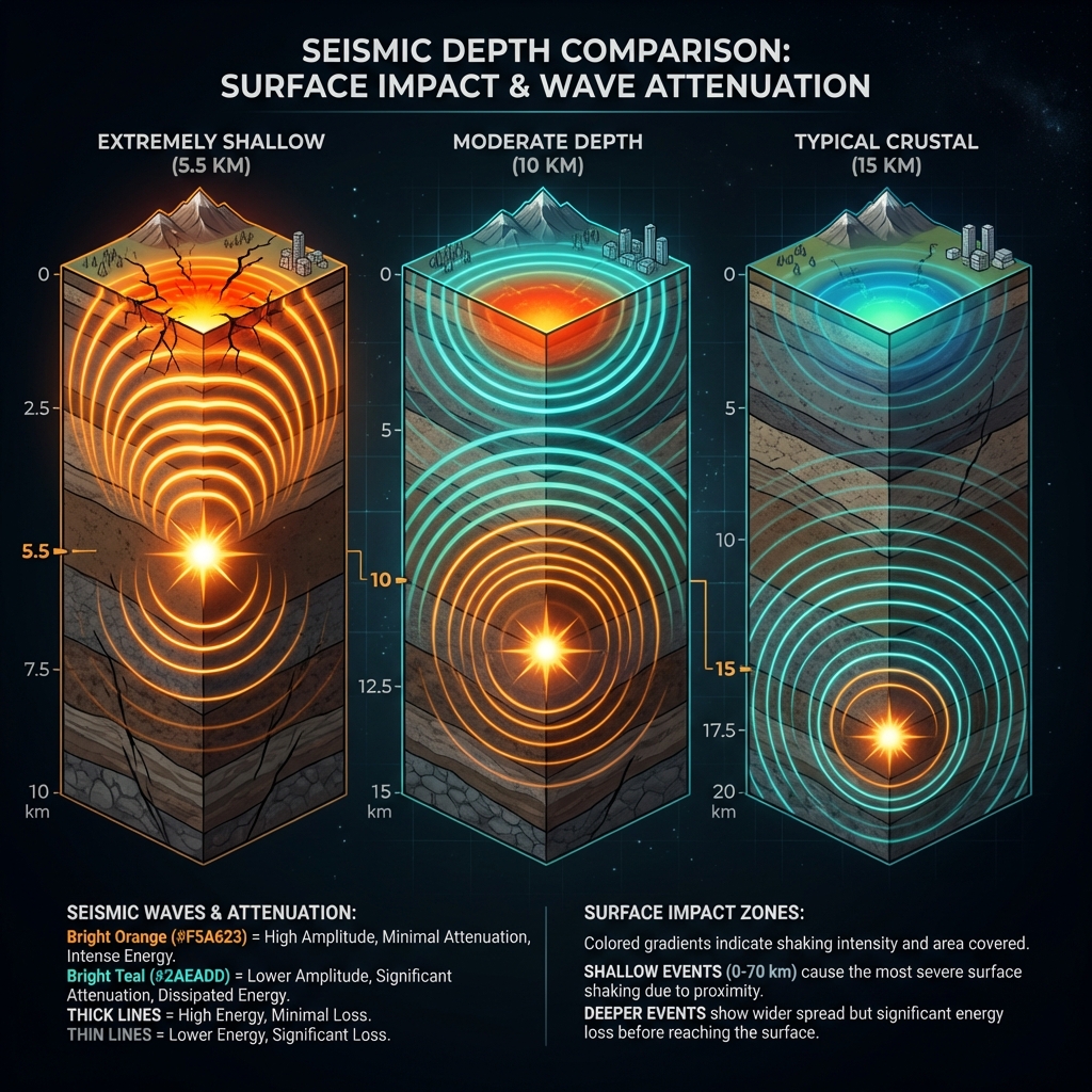
Depth determines destiny in seismology. At 5.53 kilometers, this earthquake qualifies as extremely shallow—most crustal earthquakes in the region occur between 10 and 15 kilometers down. Seismologists classify events less than 70 kilometers deep as “shallow-focus,” but anything under 10 kilometers delivers energy to the surface with minimal attenuation, meaning the shaking feels sharper and more abrupt than a deeper quake of equal magnitude.
The tremor likely generated light to moderate shaking intensity around the epicenter near Akdeniz, comparable to the rumble of a heavy truck passing nearby, though the offshore location spared inland populations from the strongest effects. By comparison, the region’s recent seismic swarm included a similarly sized M4.8 event near Kýthira, Greece, last week, but at twice the depth—approximately 10 kilometers—which would have distributed its energy across a broader area with less punch at any single location.
| Event | Location | Magnitude | Depth | Date |
|---|---|---|---|---|
| Recent Turkey Event | Akdeniz, Muğla | M4.8 | 5.5 km | April 8, 2026 |
| Recent Greece Event | 95 km SW of Kýthira | M4.8 | 10 km | Last 7 days |
| Historical Reference | 36 km W of Kíssamos | M6.6 | ~10-15 km* | October 12, 2013 |
| Historical Reference | 26 km NE of Kýthira | M6.7 | ~10-15 km* | January 8, 2006 |
*Approximate depths typical for regional crustal events.
What Should We Watch For in the Coming Days?
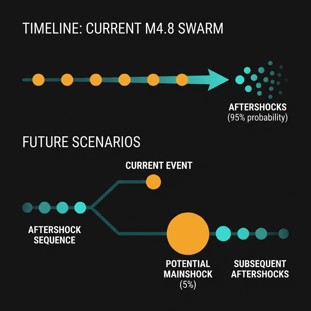
This earthquake arrives as the sixth tremor in a localized swarm over the past seven days, suggesting the crust is currently adjusting to small stress changes rather than releasing one major rupture. Seismologists will monitor whether these events represent foreshocks to a larger mainshock—a pattern observed in approximately 5% of earthquake sequences—or simply the background chatter of an active tectonic margin working through its daily business.
For now, the absence of tsunami warnings reflects both the moderate magnitude and the strike-slip or normal faulting mechanism typical of these extensional environments, which displace rock primarily horizontally or vertically rather than lifting the seafloor column of water necessary to generate ocean-crossing waves. Residents should expect occasional aftershocks in the M3 to M4 range as the fault zone settles, but the historical record suggests this region remains capable of far larger surprises.
Frequently Asked Questions
How strong was this earthquake?
The event registered as magnitude 4.8 on the moment magnitude scale, a moderate earthquake capable of rattling dishes and disturbing sleep but unlikely to cause significant structural damage in well-built areas. Its shallow depth of 5.5 kilometers meant the shaking felt locally more intense than a deeper quake of the same magnitude would produce.
Is there a risk of a tsunami?
No tsunami warning was issued for this event. The magnitude 4.8 release lacked the vertical seafloor displacement necessary to displace large volumes of water, and the Aegean Sea’s complex bathymetry further dampens tsunami potential from smaller offshore earthquakes. Only earthquakes approaching magnitude 7.0 or greater in this region typically generate tsunamis capable of affecting distant coastlines.
Why is this area so seismically active?
The Aegean region sits at the junction of the African, Aegean, and Anatolian plates, where subduction and continental extension create a network of active normal and strike-slip faults. This tectonic squeezing and stretching has produced nine magnitude 6+ earthquakes within 200 kilometers of this location since 1994, including the destructive M6.6 Kíssamos earthquake in 2013.
Track this event live on the map!
Download GeoShake and get instant earthquake alerts.
Download GeoShake