
Just 4.6 kilometers beneath the sunbaked hills of eastern Crete—shallower than the deepest foundations of New York City’s skyscrapers—the Earth gave a sharp, abrupt jolt. At 12:47 PM UTC on April 17, a magnitude 4.1 earthquake struck the Aegean Sea near the Greek island, according to USGS data, sending subtle but unmistakable tremors across coastal communities. The event was not an isolated incident. It arrived as the eighth beat in a week-long seismic drumroll, part of an active swarm that has seen eight earthquakes rattle the Hellenic subduction zone in just seven days, a region with a documented history of unleashing magnitude 6-plus destruction.
Why Is This Region So Seismically Active?
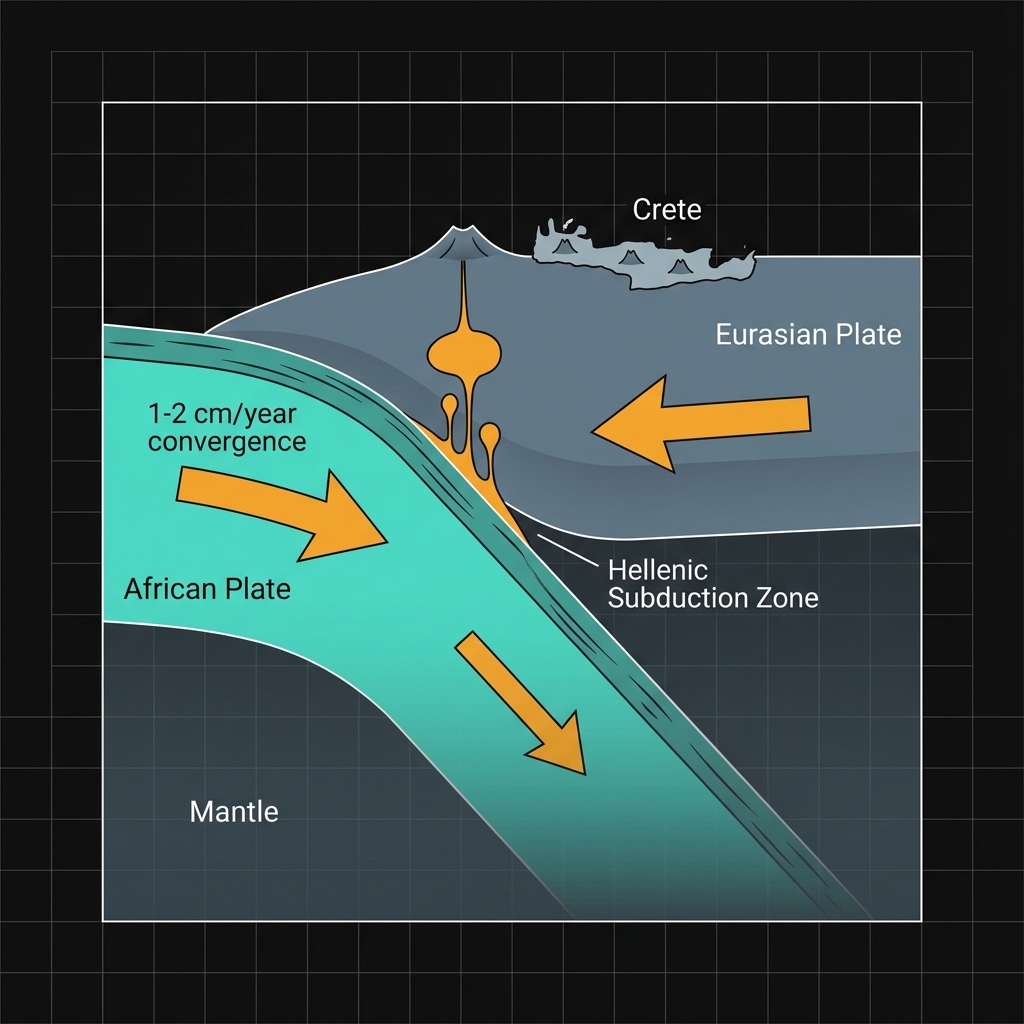
This corner of the Mediterranean is a textbook example of tectonic violence. Here, the African Plate grinds northward, diving beneath the Eurasian Plate in a slow-motion collision that has sculpted the region’s archipelagos and deep-sea trenches over millions of years. Crete sits like a cap on the overriding plate margin, caught directly in the crunch. Seismologists classify this as a subduction zone—a geological factory for some of the planet’s most powerful earthquakes, where the denser oceanic crust sinks into the mantle, dragging and deforming the overlying landmass.
The historical record bears this out with sobering regularity. Over the past four decades, a 200-kilometer radius around this swarm has hosted a parade of destructive magnitude 6-plus events. In 2021, a magnitude 6.4 shock struck just 79 kilometers away near Palekastro, Greece, damaging hundreds of structures and reminding residents that the fault systems here remain primed for rupture. Two years prior, in 2020, a magnitude 6.5 event rocked the seafloor south of Néa Anatolí, while 2013 brought a magnitude 6.6 temblor west of Kíssamos. Even more recently, a magnitude 6.2 quake occurred in 2025 southeast of Emporeío, roughly 97 kilometers from this latest swarm. These are not statistical outliers; they are the characteristic expression of a boundary that accumulates stress at roughly one to two centimeters per year—a geologically brisk pace that ensures the Hellenic Arc remains one of Europe’s most hazardous seismic zones.
What Does This Shallow Depth Mean for Shaking?
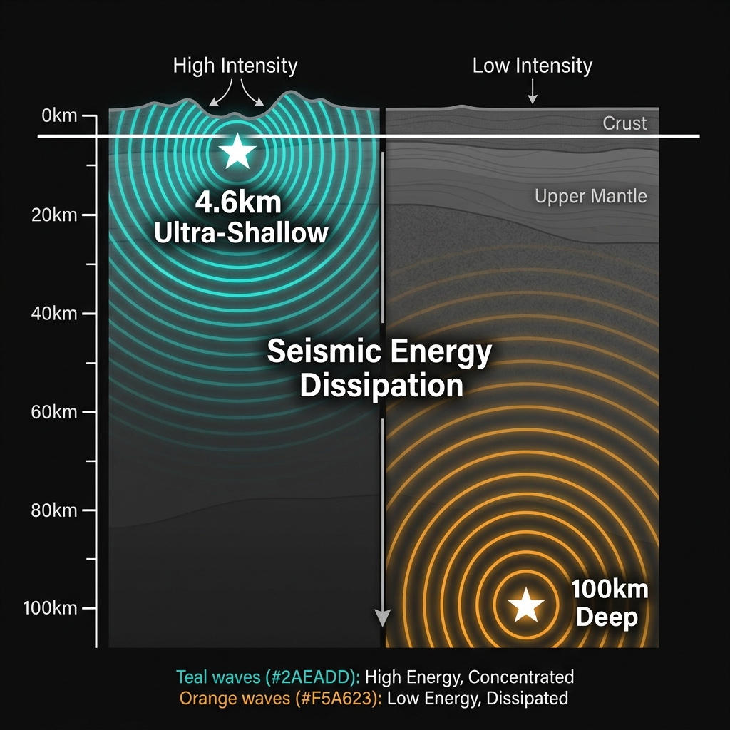
Depth is destiny in seismology. When an earthquake originates just 4.6 kilometers down, the seismic energy has barely any rock to dissipate through before it hits the surface. This proximity transforms even moderate magnitudes into perceptible, sometimes alarming experiences. Seismologists classify earthquakes with depths less than 70 kilometers as “shallow-focus,” but this event sits in the ultra-shallow category—closer to the surface than the peak of Mount Olympus is high.
The practical effect is intensity. A magnitude 4.1 at 4.6 kilometers depth can feel like a heavy truck colliding with a building, jolting awake sleepers and rattling unsecured objects, whereas the same magnitude at 100 kilometers might register only as a gentle swaying detectable by instruments. This particular swarm illustrates the variability of crustal adjustment: just days earlier, a magnitude 4.3 event occurred at 10 kilometers depth roughly 31 kilometers southwest of Kastrí, Greece—more than twice as deep as the April 17 event, yet similar in magnitude. The cluster shows the crust here is adjusting at multiple levels, from the near-surface sedimentary layers down to the brittle-ductile transition zone where rock begins to deform plastically rather than breaking.
| Date | Magnitude | Depth (km) | Location Relative to Crete |
|---|---|---|---|
| April 17, 2026 | 4.1 | 4.6 | Near Girit Adası (Datça) |
| Previous 7 days | 4.3 | 10.0 | 31 km SW of Kastrí, Greece |
| Previous 7 days | Various | 5-15 | Hellenic Arc region |
Note: Data represents select events from the eight-earthquake swarm recorded in the week preceding April 17, illustrating the variation in focal depth and magnitude within the cluster.
What Should We Watch For Next?
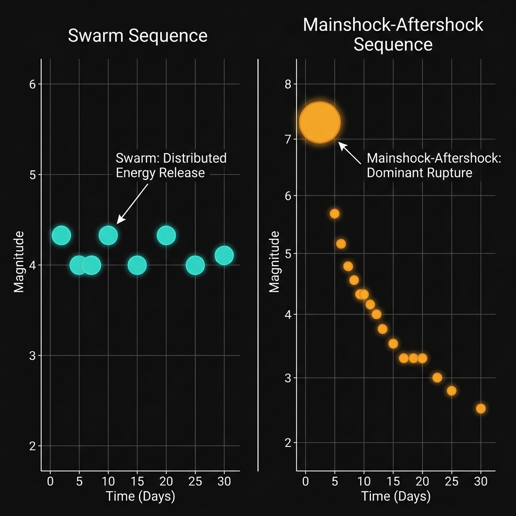
Swarms differ fundamentally from the classic mainshock-aftershock sequence that most people associate with earthquakes. In a swarm, no single event clearly dominates the energy release; instead, a localized area adjusts through numerous similar-sized ruptures over days or weeks. This pattern can indicate fluid migration along fault zones or incremental stress redistribution in the upper crust. However, seismologists remain vigilant because swarms in subduction zones sometimes foreshadow larger events, particularly when they occur in regions with a proven capacity for magnitude 6-plus ruptures. Given this area’s history—including the 1994 magnitude 6.1 quake just 72 kilometers away and multiple significant events in the 21st century—instruments here are watched with particular care. For now, the activity suggests continued restlessness along the Hellenic Arc, a reminder that this ancient tectonic boundary remains very much alive and capable of generating destructive shaking.
Frequently Asked Questions
How strong was this earthquake?
The earthquake registered as a magnitude 4.1 on the moment magnitude scale, a moderate event that was likely felt by people in coastal areas of Crete and western Turkey. Because it occurred at an exceptionally shallow depth of only 4.6 kilometers, the shaking would have been more pronounced than a deeper quake of similar magnitude, potentially causing light rattling of objects without structural damage.
Is there a tsunami risk?
No tsunami warning was issued for this event, and the risk remains minimal for earthquakes of this magnitude and depth. Tsunamis typically require larger vertical seafloor displacement, usually from magnitude 6.5-plus earthquakes or significant underwater landslides triggered by shaking, neither of which occurred here.
Why is this area so seismically active?
The region sits atop the Hellenic subduction zone, where the African Plate slides beneath the Eurasian Plate at a rate of roughly one to two centimeters per year. This collision creates immense friction and stress along the plate boundary, periodically releasing energy through earthquakes ranging from minor tremors to destructive magnitude 6-plus events, as evidenced by the 2013 M6.6 and 2021 M6.4 quakes in the area.
Track this event live on the map!
Download GeoShake and get instant earthquake alerts.
Download GeoShake