
Just ten kilometers beneath the seafloor—shallower than the cruising altitude of a commercial airliner—a magnitude 5.2 earthquake ruptured off Peru’s southern coast on April 16, 2026. The tremor struck at 08:09 UTC approximately 102 kilometers southwest of Paracas, according to USGS data, placing it squarely within the same subduction zone that generated the catastrophic magnitude 8.0 earthquake nearly two decades ago. This shallow depth concentrates seismic energy near the surface, making even moderate quakes feel significantly more intense than their deeper counterparts.
Why Does This Region Generate Such Powerful Earthquakes?
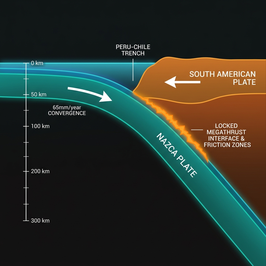
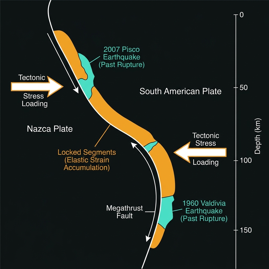
The answer lies beneath the waves, where the oceanic Nazca Plate grinds beneath the South American continent at a rate of roughly 65 millimeters per year. This process, known as subduction, forces one tectonic plate beneath another along the Peru-Chile Trench, creating a massive locked interface that stores elastic strain over centuries. Seismologists classify this as a convergent margin, and it represents one of the most seismically hazardous environments on Earth.
This particular stretch of coastline has a long and violent memory. In 2007, a magnitude 8.0 earthquake struck just 143 kilometers from Paracas, killing hundreds and leveling tens of thousands of buildings. That event released roughly 1,000 times more energy than today’s tremor. Historical records reveal this zone’s persistent volatility: a magnitude 7.7 event in 1996, a 6.9 in 2011, and numerous magnitude 6-plus quakes peppering the decades between. These events occur along the megathrust fault interface and within the overriding South American Plate, creating a complex seismic tapestry.
| Event | Magnitude | Distance from Paracas | Year | Notable Impact |
|---|---|---|---|---|
| Today’s earthquake | 5.2 mb | 102 km | 2026 | Shallow, offshore |
| Pisco earthquake | 8.0 | 143 km | 2007 | Catastrophic damage, 500+ fatalities |
| Changuillo earthquake | 7.7 | 123 km | 1996 | Tsunami generated |
| Santiago earthquake | 6.9 | 90 km | 2011 | Strong local shaking |
| Cañete earthquake | 6.7 | 134 km | 2006 | Significant regional impact |
What Does Ten Kilometers of Depth Mean for Shaking?
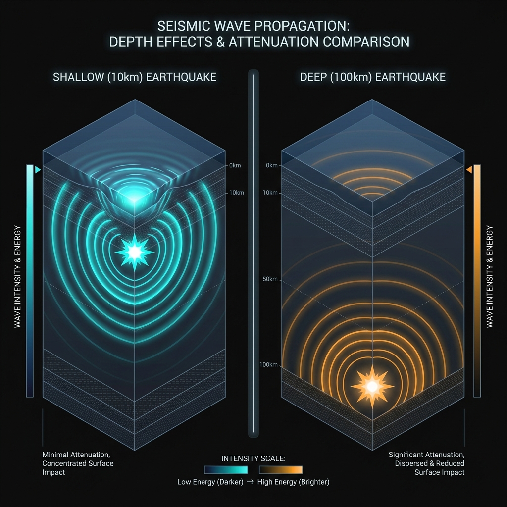
Seismologists describe earthquakes as shallow when they occur less than 70 kilometers deep, but this event’s 10-kilometer focus places it in the uppermost crust, directly beneath the seafloor. At such shallow depths, seismic waves have less rock to travel through before reaching the surface, meaning they arrive with far less attenuation than they would from a 100-kilometer-deep event. The result is sharper, more jarring motion—similar to the difference between feeling a drumbeat through the floor versus hearing it from upstairs.
A magnitude 5.2 earthquake releases energy roughly equivalent to 1,000 tons of TNT, or about one-twentieth the power of the atomic bomb dropped on Hiroshima. Had this occurred directly beneath a city, it could have caused moderate structural damage to unreinforced masonry buildings and significant alarm to residents. However, at 102 kilometers offshore, the shaking likely manifested as a gentle rolling motion for coastal residents, detectable but not destructive. The event generated no tsunami threat, according to USGS assessments, as the vertical seafloor displacement was insufficient to displace the water column significantly.
Is This a Prelude to Something Larger?
Over the past seven days, seismic monitoring networks recorded only this single earthquake within a 200-kilometer radius of Paracas, suggesting this is an isolated stress release rather than the beginning of a swarm. However, seismologists remain vigilant when monitoring subduction zones, where magnitude 5 events can occasionally serve as foreshocks to larger ruptures. The 2007 M8.0 Pisco earthquake was preceded by several magnitude 4 and 5 tremors in the preceding months, though scientists cannot reliably predict whether any given small earthquake will escalate.
This event serves as a reminder that the Nazca-South American plate boundary continues accumulating strain. The 2007 rupture released only a portion of the stored energy along this segment, leaving portions of the megathrust still locked and loaded. Geoscientists will scrutinize this earthquake’s focal mechanism—essentially its fault orientation and slip direction—to determine whether it occurred on the main subduction interface or within the upper plate, information that helps refine hazard assessments for coastal communities from Lima to Nazca.
Frequently Asked Questions
How strong was this earthquake?
This earthquake registered as magnitude 5.2 on the moment magnitude scale, which seismologists use to measure the size of modern earthquakes. It released approximately 1,000 tons of TNT equivalent energy. Because it struck at a shallow depth of only 10 kilometers, the shaking would have felt more intense than a deeper quake of the same magnitude, though its offshore location meant coastal populations experienced only light to moderate tremors.
Is there a tsunami risk from this event?
No tsunami warning was issued for this earthquake. Tsunamis typically require substantial vertical displacement of the seafloor during underwater earthquakes, usually magnitude 7.0 or greater, or massive underwater landslides. This magnitude 5.2 event lacked the vertical thrust component and energy release necessary to displace significant ocean water volume, making a tsunami virtually impossible.
Why is this area so seismically active?
This region sits atop the Peru-Chile subduction zone, where the Nazca Plate dives beneath the South American Plate at approximately 6.5 centimeters per year. This collision creates immense friction and pressure along the megathrust fault interface. Every few decades, this stored strain releases as major earthquakes, including the devastating 2007 magnitude 8.0 Pisco earthquake that struck just 143 kilometers from today’s epicenter.
Track this event live on the map!
Download GeoShake and get instant earthquake alerts.
Download GeoShake