
Thirty-seven times in seven days, the earth shivered beneath the Mediterranean waters off Turkey’s Turquoise Coast. The sequence culminated on April 2, when a magnitude 4.2 tremor struck at 7:35 PM local time, making it the most powerful jolt in a persistent earthquake swarm rattling the seabed near Demre, according to USGS data. Originating 28 kilometers below the surface—deep enough to blunt its surface impact but shallow enough to remind residents that the region’s geological restlessness continues unabated—the event highlights an uncomfortable reality: the same tectonic machinery that generates these minor tremors has historically produced far more destructive ruptures in this volatile corner of the eastern Mediterranean.
Why Is This Region So Seismically Active?
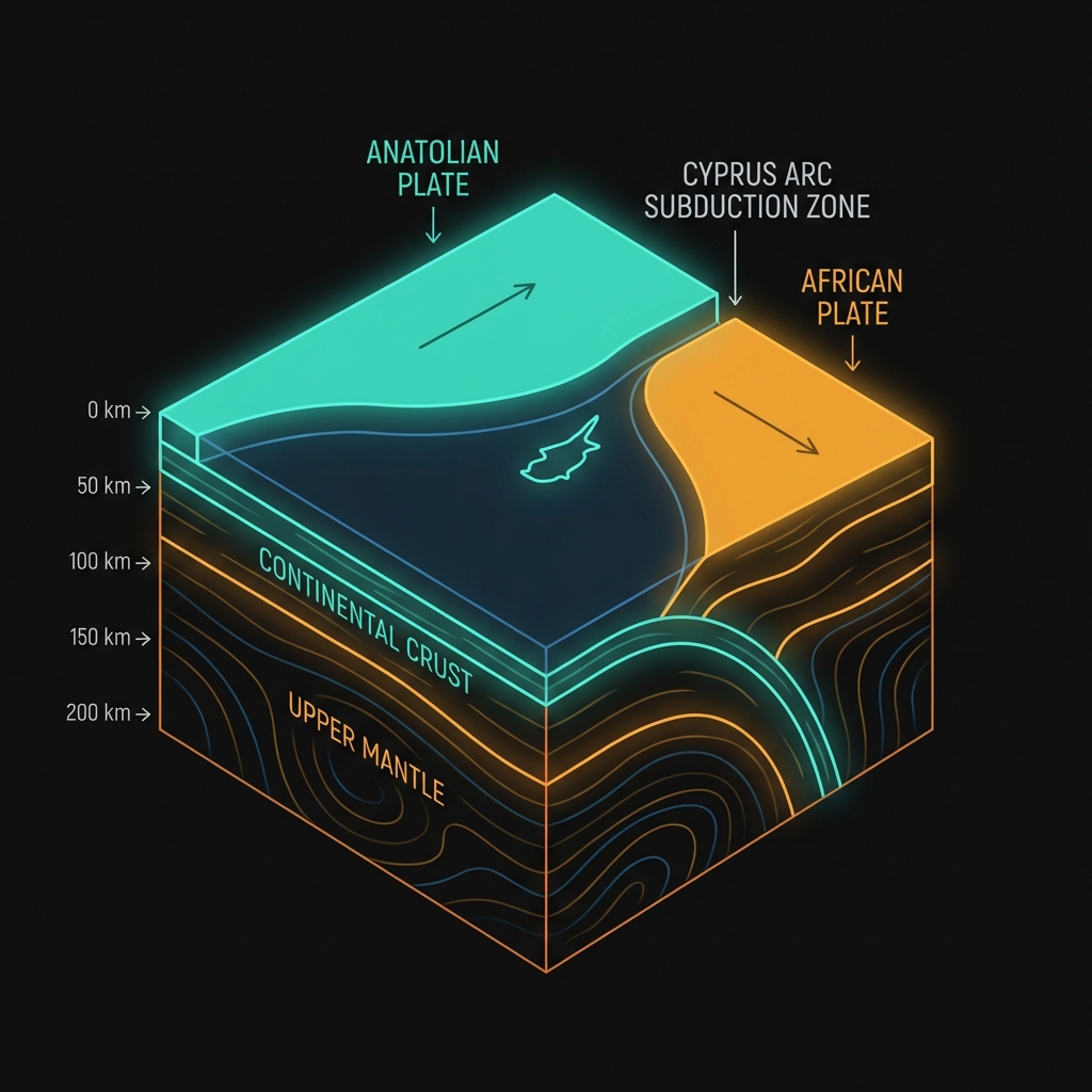
The Antalya coastline sits at a complex tectonic crossroads where the Anatolian Plate grinds against the northward-moving African Plate. This collision zone, part of the broader Cyprus Arc subduction system—where one plate dives beneath another—creates a crucible of compression and shear that periodically releases energy through earthquakes. Seismologists classify this as a region of moderate-to-high seismic hazard precisely because it hosts the kind of fault networks capable of both small swarms and devastating mainshocks.
The historical record bears this out with unsettling clarity. In 2012, a magnitude 6.0 earthquake struck 28 kilometers southwest of Ölüdeniz, roughly 146 kilometers from the current swarm’s epicenter, causing structural damage and injuring dozens. A decade later, in 2022, a magnitude 6.6 event ruptured near Cyprus, approximately 161 kilometers away, demonstrating that stress accumulation along these offshore faults can release energy roughly 1,000 to 4,000 times stronger than the April 2 event. These events serve as reference points for what this region’s geology can produce when major fault segments fail.
What Does the Depth and Magnitude Reveal?

To contextualize the current unrest, consider the energy differential between this swarm and the region’s historical heavyweights. The following table places the recent activity against significant regional earthquakes:
| Event | Magnitude | Depth | Distance from Current Swarm | Relative Energy Release |
|---|---|---|---|---|
| April 2, 2026 (largest of swarm) | 4.2 MW | 28 km | 0 km (epicenter) | 1x (baseline) |
| 2012 Ölüdeniz earthquake | 6.0 | ~10 km | 146 km SW | ~63x stronger |
| 2022 Cyprus earthquake | 6.6 | ~70 km | 161 km away | ~251x stronger |
At magnitude 4.2, the April tremor released energy equivalent to roughly 1,000 tons of TNT. This is enough to rattle windows and disturb furniture in coastal towns like Demre and Kaş, creating the sensation of a heavy truck passing nearby, but insufficient to cause structural damage to well-built modern structures. The 28-kilometer depth placed it within the upper brittle crust—the rigid outer layer of rock that stores elastic strain—meaning the energy had less rock to travel through before reaching the surface compared to deeper mantle events. However, this depth also meant the rupture occurred within the rigid upper layer where earthquakes typically feel sharper and more abrupt than deeper, rolling temblors.
Seismologists note that earthquake swarms—sequences of many events without a single dominant mainshock—differ fundamentally from the more common mainshock-aftershock patterns. This diffuse release of stress across multiple small faults rather than one major rupture suggests complex, localized adjustments in the crust rather than a single locked fault breaking. While this pattern often indicates a lower immediate risk of a catastrophic mainshock compared to a classic foreshock sequence, it reveals that the crust remains under significant tectonic pressure.
What Should We Watch For?
Swarms often fade gradually over days or weeks, but they occasionally foreshadow larger events, particularly in regions with demonstrated capacity for magnitude 6+ ruptures like this one. The Turkish Disaster and Emergency Management Authority (AFAD) and international monitoring networks will watch closely for any migration of epicenters toward land, changes in depth that might indicate evolving stress patterns, or the emergence of a clear mainshock-aftershock sequence that would signal a different type of seismic threat. While the probability of a destructive earthquake remains low on any given day, the 2012 and 2022 events illustrate that this coastline must maintain perpetual readiness, as the geological forces driving this week’s 37 tremors remain active, accumulating stress that will inevitably release again—whether tomorrow or decades hence.
Frequently Asked Questions
How strong was this earthquake?
The earthquake registered as magnitude 4.2 on the moment magnitude scale, making it a light event capable of causing noticeable shaking indoors and rattling dishes, but typically not strong enough to damage buildings designed to modern seismic codes. It was the most powerful of 37 earthquakes to strike the region within a single week.
Is there a risk of a larger earthquake following this swarm?
While most earthquake swarms dissipate without triggering a major rupture, this region has produced destructive magnitude 6.0 and 6.6 earthquakes in 2012 and 2022 respectively. Seismologists consider the risk of a larger event elevated during active sequences, though not inevitable, and recommend maintaining standard emergency preparedness.
Why is Turkey’s Mediterranean coast so prone to earthquakes?
The coastline lies near the boundary between the Anatolian and African tectonic plates, specifically along the Cyprus Arc where subduction and strike-slip forces create constant stress. This tectonic setting generates frequent small adjustments—like the current swarm—and occasional large destructive ruptures when stress accumulates on major fault lines.
Track this event live on the map!
Download GeoShake and get instant earthquake alerts.
Download GeoShake