
The Echo of Giants
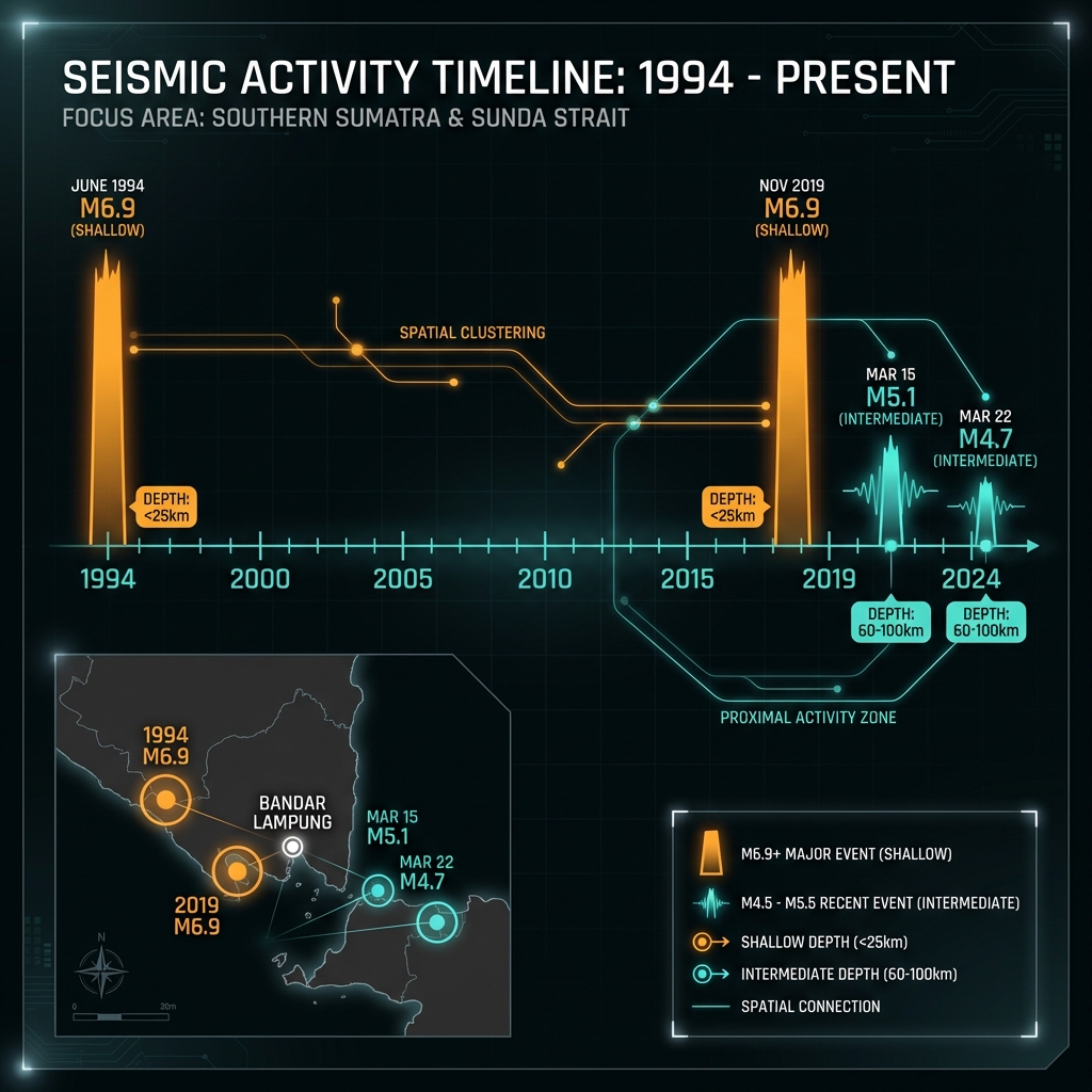
The tremor struck at 3:51 AM UTC on March 22nd—a brief, sharp pulse through the seafloor 188 kilometers southwest of Bandar Lampung. At magnitude 4.7, the offshore quake was modest by the standards of the Sunda Trench, releasing roughly five hundred times less energy than the true monsters this region can unleash. Yet for seismologists monitoring this stretch of southern Sumatra, the event carried the distinct signature of a corridor that has twice produced magnitude 6.9 earthquakes in living memory: once in 1994 near Kotabumi, and again in 2019 closer to Labuan, both within 200 kilometers of Sunday’s epicenter and both serving as stark reminders that the crust here is never truly quiet.
The Mechanics of a Subduction Zone
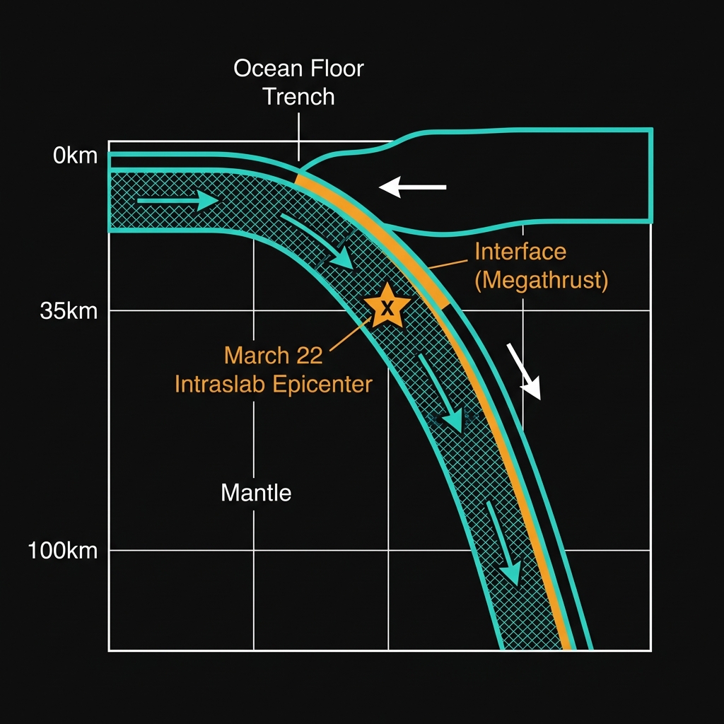
This is the grinding edge of the Sunda subduction zone, where the Indo-Australian plate dives beneath the Eurasian plate at roughly six centimeters per year—the same inexorable geological collision that raised the Indonesian archipelago and, in 2004, triggered one of history’s deadliest tsunamis 400 kilometers to the north. Here, the oceanic crust doesn’t slide smoothly into the mantle; it sticks, strains, and periodically ruptures. The historical record for this patch of seafloor reads like a catalog of barely contained energy: since 1992, seismometers have recorded ten magnitude 6-plus earthquakes within this radius, including a M6.8 shock near Labuan in 2000 and a M6.6 event just three years ago.
Seismologists classify earthquakes in this region into two distinct categories. Interface earthquakes occur along the shallow, friction-locked contact between the colliding plates, often producing the most destructive shaking and tsunami potential. But Sunday’s event, centered 35 kilometers beneath the surface, likely represents an intraslab rupture within the descending Indo-Australian plate itself—where the crust bends and cracks under the immense pressure and changing temperatures of subduction. These deeper quakes typically generate less surface damage than their shallow counterparts, but they can be felt over surprisingly wide areas because the seismic waves travel efficiently through the rigid mantle before reaching the surface.
Reading the Seismic Signature
For residents on land, the practical implications of Sunday’s earthquake were minimal. At a depth of 35 kilometers—what seismologists classify as intermediate—shaking from the M4.7 event would have attenuated significantly before reaching the coast. Anyone awake in Bandar Lampung, nearly 190 kilometers away, might have noticed a gentle swaying or a brief, low rumble, though the sensation would have been subtle, comparable to the vibrations from heavy construction equipment or a large truck passing nearby. The United States Geological Survey reported no tsunami threat, as the vertical displacement of the seafloor was insufficient to displace a significant volume of water.
The timing of this event is particularly noteworthy when viewed against the region’s recent behavior. Just days earlier, on March 15th, a M5.1 earthquake struck 156 kilometers southwest of Labuan at a shallow depth of just 10 kilometers—part of a cluster of two significant tremors recorded in the preceding week. While seismologists caution against interpreting short-term clustering as a definitive precursor to larger events, these patterns illustrate the complex stress redistribution that occurs in subduction zones. The 1994 and 2019 M6.9 events bookended a quarter-century of intermittent, moderate shaking; Sunday’s tremor fits neatly into this ongoing narrative of crustal adjustment, neither anomalous nor entirely reassuring.
The Long View
For GeoShake monitors tracking the slow dance between tectonic plates, this earthquake offers a calibration point—a gentle pulse from a system capable of far greater violence. The Sunda Trench stores centuries of accumulated plate motion, releasing it in fits and starts that range from barely perceptible tremors to continent-shaking megathrust events. As sensors continue to map the bending and breaking of the Indo-Australian slab beneath Sumatra, each moderate quake serves a dual purpose: acting as a pressure valve for local stress while simultaneously redistributing load to adjacent segments of the fault. In the silence between these tremors, the earth continues loading its springs, reminding us that the geology beneath our feet remains restless, patient, and immensely powerful.
Track this event live on the map!
Download GeoShake and get instant earthquake alerts.
Download GeoShake