
The ground did not have far to travel. When a magnitude-5.3 earthquake struck 33 kilometers northwest of Barishal, Pakistan, late Thursday evening, it originated just 10 kilometers beneath the surface—shallow enough to turn a moderate tremor into a sharp jolt that could rattle structures and fray nerves across the region, according to USGS data. At 21:02 UTC on March 26, communities across the Himalayan foothills felt the earth move with an intensity that belied the earthquake’s middling magnitude, a reminder that in seismology, depth is often as consequential as raw power. For residents of this rugged northern landscape, the proximity of the rupture to the surface meant seismic waves arrived with minimal dissipation, carrying the full punch of the crustal slip directly to foundations and fields.
Why Is This Region So Seismically Active?
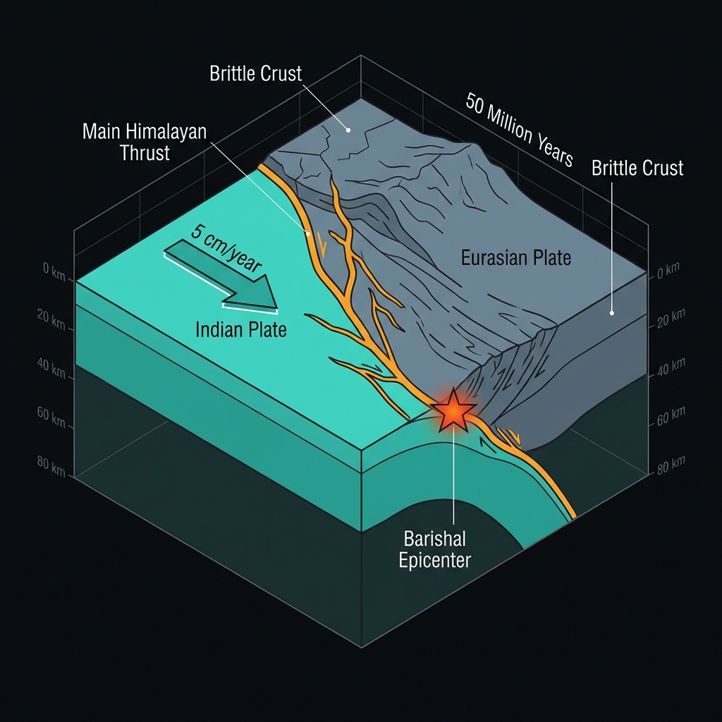
This corner of northern Pakistan sits at the collision zone between the Indian and Eurasian tectonic plates, a slow-motion car crash that has been building the Himalayas for roughly 50 million years. The stress accumulates as India pushes northward into Asia at about five centimeters per year—roughly the rate fingernails grow—periodically releasing in sudden lurches that shake the rugged terrain. Geologists call this the Main Himalayan Thrust system, a complex network of faults where the Indian plate dives beneath the Tibetan plateau, creating one of the most seismically hazardous regions on Earth.
Historical records reveal this specific vicinity is no stranger to significant shaking. Over the past four decades, the 200-kilometer radius around Barishal has hosted several magnitude-6-plus events, each releasing roughly ten to fifty times more energy than Thursday’s tremor. In 2002, a M6.3 earthquake struck 58 kilometers southeast of Gilgit, Pakistan, while the Afghanistan-Pakistan border region experienced twin significant events in 1990—a M6.3 and M6.2 pair near Khandud, Afghanistan. More recently, in 2023, a M6.9 event rocked western Tajikistan, demonstrating that the regional tectonic forces remain as active as ever.
| Year | Magnitude | Location | Distance from Barishal |
|---|---|---|---|
| 2023 | 6.9 | 65 km WSW of Murghob, Tajikistan | 199 km |
| 2002 | 6.3 | 58 km SSE of Gilgit, Pakistan | 127 km |
| 1990 | 6.3 | 56 km E of Khandud, Afghanistan | 145 km |
| 1990 | 6.2 | 62 km E of Khandud, Afghanistan | 134 km |
Seismologists note that while these historical events occurred on different specific fault segments, they share the same driving force: the relentless continental collision that stores elastic energy in the crust until the rock fails. The 2023 Tajikistan event, though nearly 200 kilometers distant, illustrates how stress transfers across this broad orogenic belt, with earthquakes occasionally triggering sympathetic adjustments on distant faults.
How Does Depth Change the Impact?
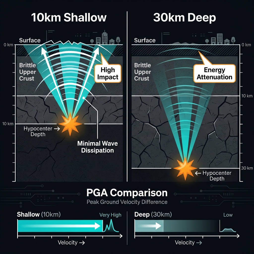
Seismologists classify earthquakes by their hypocentral depth—the point where the rupture actually begins—and at 10 kilometers, this event qualifies as shallow crustal. The mathematics of seismic waves favors shallow quakes; energy dissipates less as it travels upward, meaning the ground acceleration felt at the surface can rival that of deeper, more powerful earthquakes. To visualize this, imagine the difference between feeling a drumbeat from a speaker pressed against your chest versus one across the room. That 10-kilometer depth places the rupture well within the brittle upper crust, where rocks break in sudden, catastrophic fractures rather than slow deformations.
For perspective, a magnitude-5.3 earthquake releases roughly the energy equivalent of 80 tons of TNT—substantial, but roughly 30 times less than the M6.3 events recorded in this region’s history. However, because Thursday’s event occurred at one-third the depth of typical crustal earthquakes, the peak ground velocity likely approached levels seen in those stronger, deeper historical shocks within the immediate epicentral area. The USGS estimates that moderate shaking—enough to disturb dishes, sway furniture, and potentially crack plaster—likely extended across a localized zone near the epicenter, though the exact intensity depends heavily on local soil conditions. Unlike deep earthquakes that rumble from the mantle with slow, rolling motions, shallow events like this one generate higher-frequency waves that humans perceive as sharp, abrupt jolts. These frequencies are particularly damaging to low-rise buildings and rural masonry structures common in the region, which lack the engineered flexibility to absorb rapid ground accelerations.
What Should We Watch For Now?
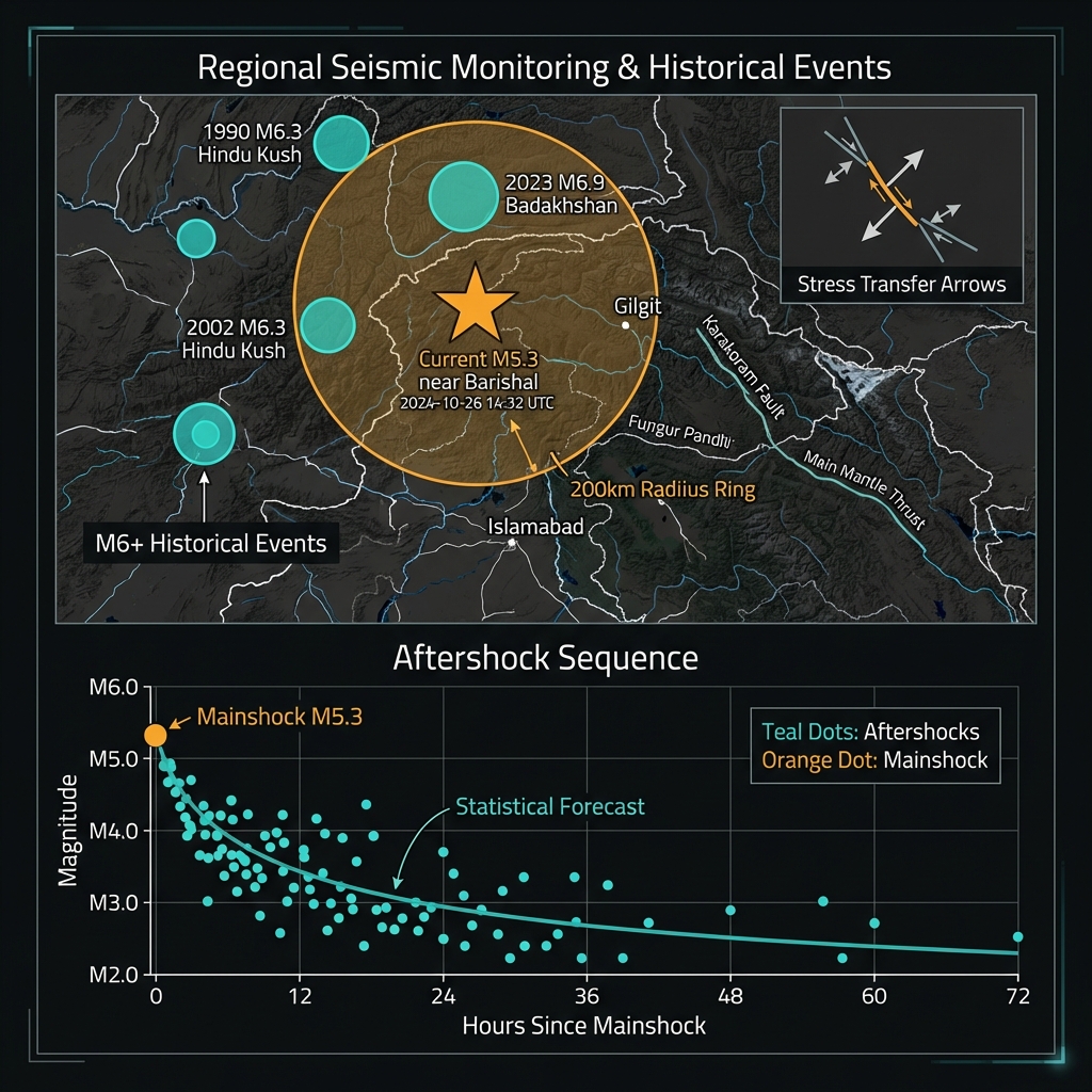
In the coming days, seismologists will monitor for aftershocks, smaller adjustments in the crust that follow the main rupture as the rock settles into its new configuration. While a single M5.3 event does not necessarily signal an impending larger earthquake, the region’s history of M6-plus activity means communities should remain prepared. Thursday’s tremor represents either an isolated stress release on a minor fault or potentially a foreshock preceding a larger event, though the latter scenario remains statistically unlikely. GeoShake continues to track regional seismicity in real-time, providing early awareness as the Himalayan belt continues its relentless, inch-by-inch transformation that will eventually raise these mountains higher than Everest.
Frequently Asked Questions
How strong was this earthquake?
A magnitude-5.3 earthquake is considered moderate, capable of causing localized damage to poorly constructed buildings near the epicenter. The shallow depth of 10 kilometers amplified the shaking intensity significantly, meaning residents likely experienced effects comparable to a stronger, deeper earthquake. While the energy released was roughly equivalent to 80 tons of TNT, the proximity to the surface meant the seismic waves retained most of their destructive potential when they reached communities.
Is there a tsunami risk?
No tsunami warning was issued for this event. According to USGS data, the earthquake occurred inland at significant distance from any ocean coastline, and tsunamis require specific conditions—typically vertical seafloor displacement during underwater earthquakes—that were not present here. The rupture occurred entirely within continental crust beneath mountainous terrain.
Why is this area so seismically active?
Northern Pakistan lies at the convergence zone between the Indian and Eurasian plates, where ongoing continental collision builds mountain ranges and stores elastic energy in the crust. This geological setting produces frequent earthquakes as the accumulated stress periodically releases along faults in the Himalayan belt. The region has experienced multiple magnitude-6-plus events in recent decades, including significant earthquakes in 1990, 2002, and 2023, confirming this remains one of Earth’s most active tectonic boundaries.
Track this event live on the map!
Download GeoShake and get instant earthquake alerts.
Download GeoShake