
The earth shifted nearly 50 kilometers beneath the surface of the Molucca Sea early Friday morning, sending a magnitude 5.9 tremor rippling through the crust near Indonesia’s eastern Sulawesi coast. The quake struck at 01:35 UTC on April 4, 2026, centered 111 kilometers east-southeast of Bitung, according to USGS data. At a depth of 48.7 kilometers, this was no shallow crustal skirmish—it was an intermediate-depth event originating within the sinking tectonic plate itself.
Why Is This Region a Seismic Hotspot?

The waters around Bitung sit atop one of the most complex tectonic collisions on Earth. Here, the Molucca Sea Plate is being consumed from both sides in a rare geological phenomenon called double subduction: the Sangihe Arc pulls it westward while the Halmahera Arc drags it eastward. This creates a seismically hyperactive zone where the crust is constantly fracturing under immense pressure.
This recent tremor did not occur in isolation. The region has been particularly restless, with 55 earthquakes recorded within a 200-kilometer radius in just the past seven days—including a powerful magnitude 7.8 event at a shallow 10-kilometer depth near Ternate. Historical records reveal this area’s volatile nature, with six magnitude-7-plus earthquakes since 1986, including a 7.5 magnitude event in 2007 just 24 kilometers from the recent epicenter. These are not statistical anomalies; they are the rhythmic pulse of plate tectonics in action.
How Does Depth Change the Danger?
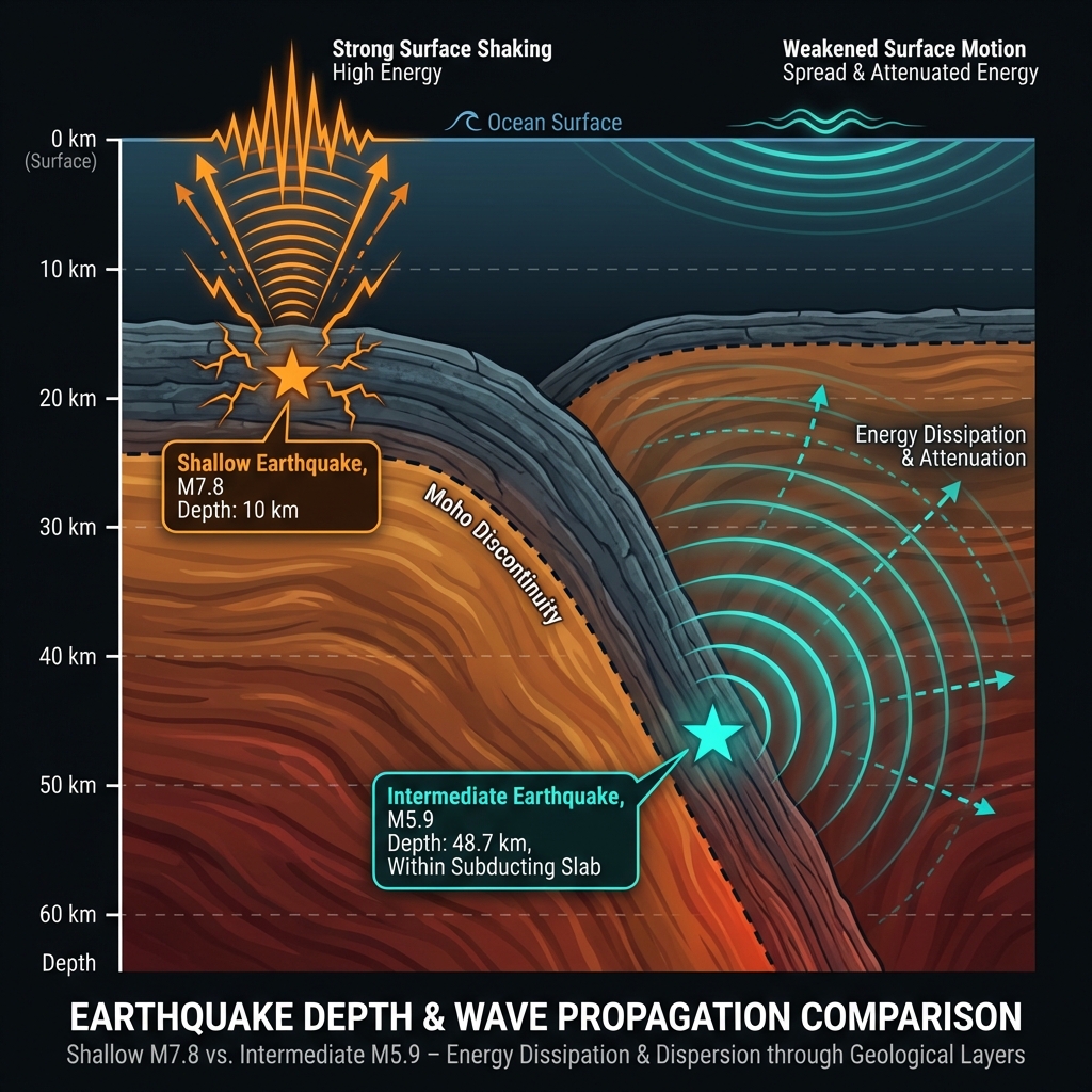
Depth is everything in seismology. At 48.7 kilometers, Friday’s earthquake originated well below the brittle crust, placing it in the upper mantle where temperatures and pressures transform rock deformation. Seismologists classify this as an intermediate-depth event, distinct from the shallow quakes that typically cause the most surface destruction.
The practical difference is stark. While the recent magnitude 7.8 near Ternate—at just 10 kilometers deep—would have produced violent, localized shaking capable of significant damage, this magnitude 5.9 event at nearly 49 kilometers depth delivered a gentler, rolling motion felt across a broader area. The seismic waves had farther to travel upward, losing energy as they passed through viscous mantle rock before reaching the surface. Residents likely experienced sensations similar to a heavy truck passing nearby rather than the sharp jolt of a shallow strike.
| Event | Magnitude | Depth | Distance from Bitung | Impact Profile |
|---|---|---|---|---|
| April 4, 2026 | 5.9 | 48.7 km | 111 km ESE | Widespread, moderate rolling |
| March 28, 2026 | 7.8 | 10 km | ~200 km NW | Intense, localized violent shaking |
| February 21, 2007 | 7.5 | 126 km WNW of Ternate | ~24 km | Severe shallow impact |
Seismologists note that intermediate-depth earthquakes like this one often occur within the downgoing slab itself as it bends and breaks under the weight of subduction. The mb magnitude scale—short for body-wave magnitude—used to measure this event specifically tracks energy traveling through Earth’s interior, confirming the deep source. This type of earthquake tells us the subduction machinery is actively grinding, releasing built-up elastic strain as the Molucca Sea Plate dives into the mantle.
What Should Residents Do Now?
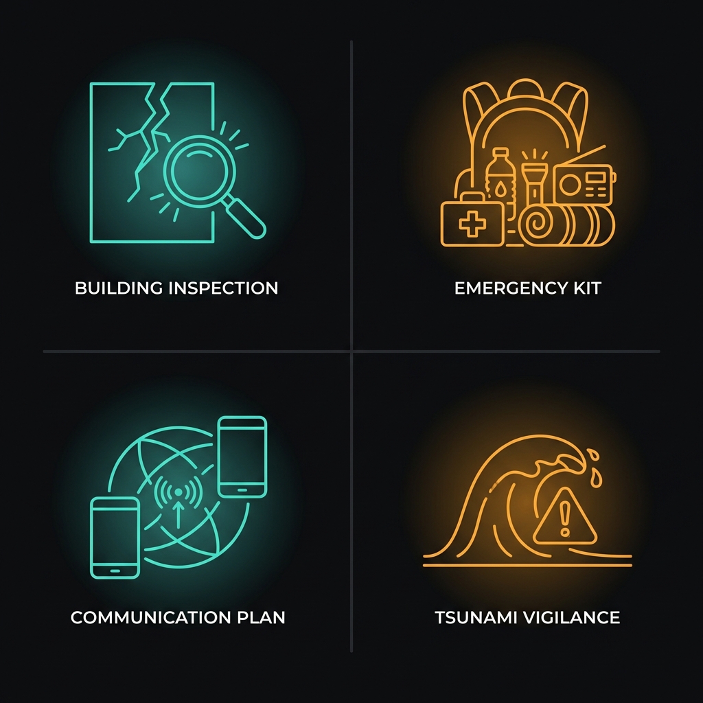
For residents in Bitung and surrounding coastal communities, this event serves as a specific reminder to inspect structures for fresh cracks or shifted foundations, even if the shaking felt moderate. Given the region’s current seismic swarm—including that recent shallow M7.8—ensure emergency kits remain stocked and accessible, and establish family communication plans now while networks are stable. Although no tsunami warning was issued for this particular earthquake due to its depth and moderate magnitude, remain vigilant for unusual ocean behavior; in this tectonically busy region, conditions can change rapidly if a larger shallow event follows.
What Happens Next?
What should we watch for in the coming days? Aftershocks are possible, potentially ranging up to magnitude 5.0 or higher given the regional stress state disturbed by the recent M7.8. Seismologists will monitor whether this intermediate-depth event represents stress adjustment within the subducting slab or foreshadows shallower activity on the plate interface. GeoShake continues tracking this active sequence, providing real-time updates as the Molucca Sea’s geological drama unfolds.
Frequently Asked Questions
How strong was this earthquake?
This was a magnitude 5.9 event measured on the body-wave scale, occurring at 48.7 kilometers depth. While significant enough to wake sleepers and rattle shelves, the intermediate depth meant surface shaking was considerably dampened compared to a shallow quake of the same magnitude.
Is there a tsunami risk?
No tsunami warning was issued for this event. The combination of its 48-kilometer depth and moderate magnitude means the vertical seafloor displacement required to generate a tsunami did not occur. However, coastal residents should always heed official warnings and move to higher ground immediately if the ground shakes strongly near the shore.
Why does this area have so many earthquakes?
The Bitung region sits at the collision point of the Sangihe and Halmahera subduction zones, where the Molucca Sea Plate is being consumed from both sides. This double subduction creates constant tectonic pressure, producing frequent powerful earthquakes as the crust accommodates the relentless motion of continental plates.
Track this event live on the map!
Download GeoShake and get instant earthquake alerts.
Download GeoShake