
Ten kilometers beneath the arid plains of western Pakistan, the earth shifted. At that shallow depth—barely six miles below the surface—a magnitude 4.5 earthquake ruptured early Thursday morning near Chowki Jamali, a remote outpost in Balochistan province, according to USGS data. While the magnitude itself falls into the “light” category on the seismic scale, the extreme shallowness of this event means the ground motion likely felt significantly more intense to those standing directly above it, delivering a sharp jolt rather than a rolling tremor.
Why Is Balochistan So Seismically Active?
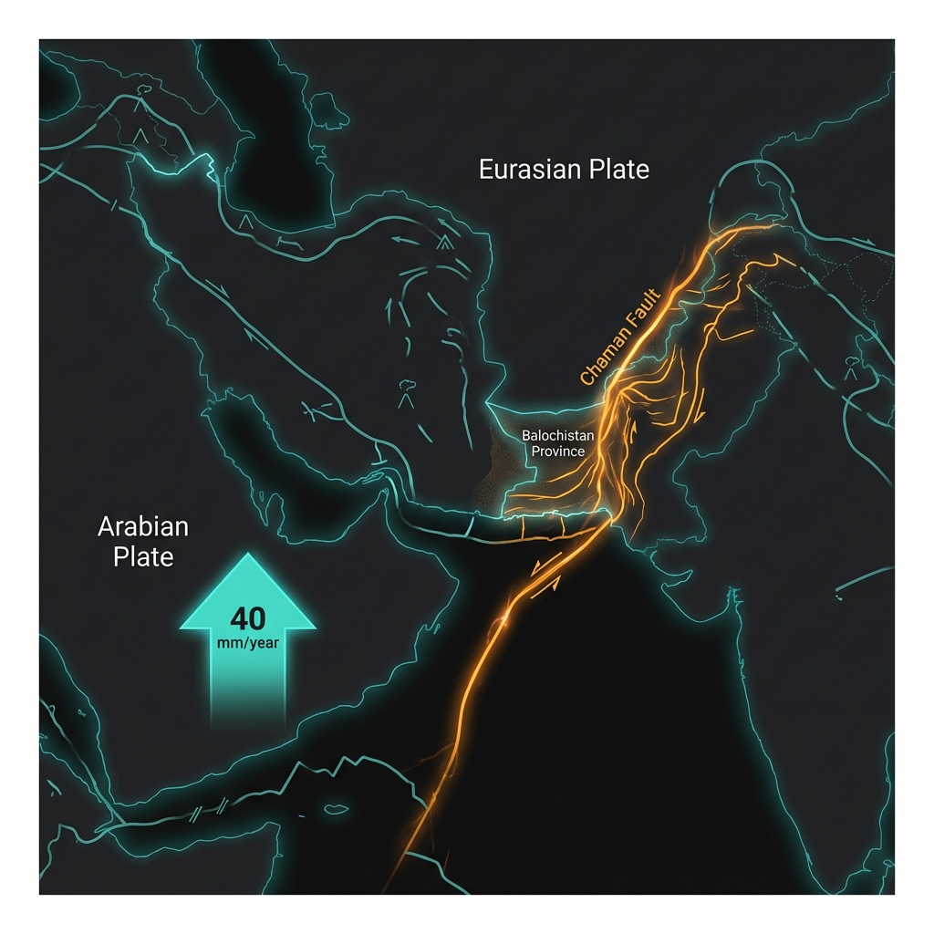
Balochistan sits at a geological crossroads that makes it one of South Asia’s most earthquake-prone regions. Here, the Arabian Plate grinds northward against the Eurasian Plate at roughly 40 millimeters per year, creating a complex zone of compression and strike-slip motion along the Chaman Fault and related structural systems. This tectonic collision, which birthed the Himalayas and continues to push them skyward, generates constant strain throughout Pakistan’s western frontier.
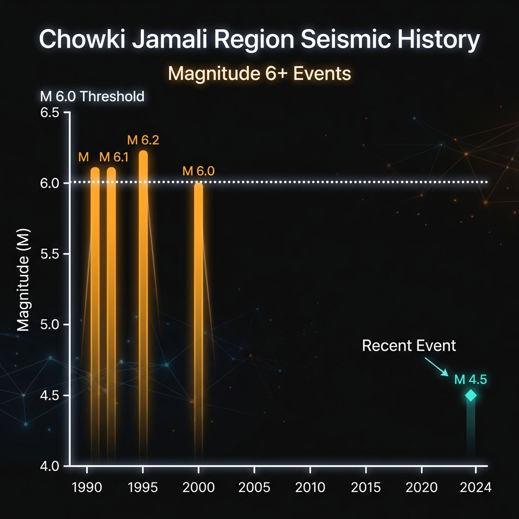
Seismologists classify this region as having high seismic hazard potential, a reputation earned through decades of destructive evidence. Over the past forty years, the area within 200 kilometers of Thursday’s epicenter has produced multiple significant events capable of causing widespread damage:
| Year | Magnitude | Location | Distance from Chowki Jamali |
|---|---|---|---|
| 1992 | 6.2 | 61 km WSW of Khuzdar | 139 km |
| 1990 | 6.1 | 99 km WSW of Khuzdar | 177 km |
| 1990 | 6.1 | 27 km WSW of Kalat | 115 km |
| 2000 | 6.0 | 15 km NNW of Kharan | 188 km |
These historical earthquakes, all exceeding magnitude 6.0, demonstrate that while Thursday’s event was moderate, the tectonic machinery beneath Balochistan is capable of generating far more powerful ruptures. The 1990 and 1992 events alone released roughly 50 to 100 times more energy than this recent tremor, illustrating the seismic scale’s logarithmic nature.
What Does Ten Kilometers Mean for Ground Shaking?
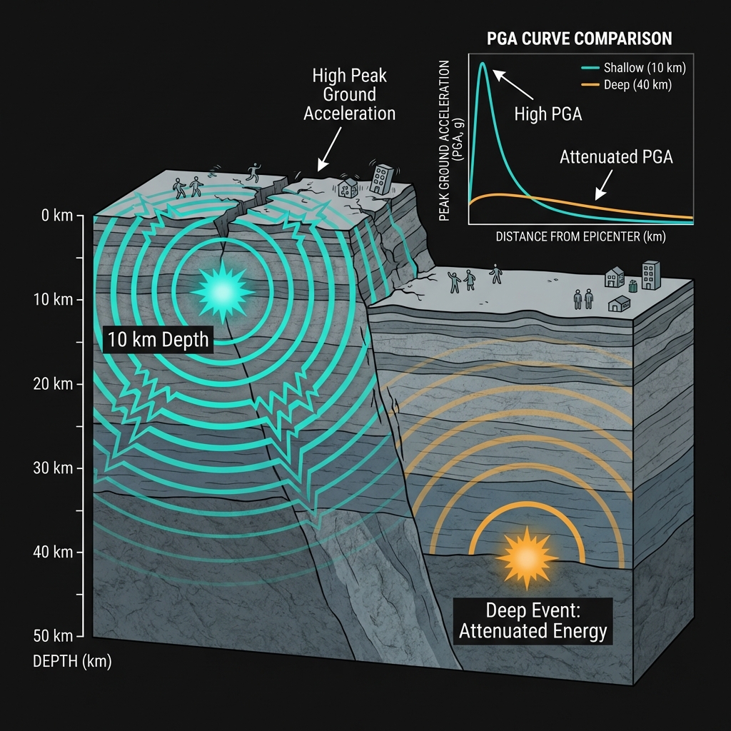
In seismology, depth matters as much as magnitude. When an earthquake occurs at just ten kilometers depth—what scientists classify as “shallow”—the seismic energy has little time to attenuate before reaching the surface. It’s the difference between feeling a drumbeat through the floor versus hearing it from down the street. For residents near Chowki Jamali, the shaking likely arrived as a sharp, sudden pulse rather than the gentle swaying associated with deeper events.
A magnitude 4.5 earthquake typically generates light shaking noticeable to most people indoors, similar to the sensation of a heavy truck passing nearby. However, at this shallow depth, the peak ground acceleration—the technical measure of how violently the ground moves—can approach levels usually associated with magnitude 5.0 or 5.5 events at standard depths. This type of earthquake tells us that stress is accumulating in the upper crust, releasing suddenly along fault planes that lie dangerously close to human settlements.
The tremor was likely felt across a radius of 50 to 70 kilometers, though the rugged terrain of Balochistan may have shielded some valleys while amplifying motion in others. Unlike deep earthquakes that send rolling waves across hundreds of kilometers, shallow events keep their energy local and intense.
What Should We Watch For?
Following Thursday’s event, seismologists will monitor for aftershocks, though the moderate magnitude suggests any subsequent tremors would likely remain below magnitude 4.0. The region has been relatively quiet recently—this 4.5 event represents the only significant earthquake within a 200-kilometer radius over the past week—suggesting it may be an isolated stress release rather than the beginning of a swarm.
However, in a province capable of producing magnitude 6.0+ earthquakes every decade or so, this shallow rupture serves as a reminder that Balochistan’s tectonic clock continues ticking. The proximity to population centers like Khuzdar and Kalat, both of which have experienced destructive shaking in living memory, underscores the importance of continued monitoring and infrastructure resilience in this geologically restless corner of Pakistan.
Frequently Asked Questions
How strong was this earthquake?
The earthquake registered magnitude 4.5, classifying it as a light but shallow event. At just 10 kilometers depth, the shaking likely felt more intense than the magnitude number suggests, potentially causing hanging objects to swing and windows to rattle, though significant damage is unlikely for events below magnitude 5.0.
Is there a tsunami risk?
No tsunami warning was issued for this earthquake. Tsunamis typically require submarine earthquakes of magnitude 6.5 or greater with significant vertical displacement of the seafloor. This event occurred inland within Pakistan’s Balochistan province, far from coastal waters, and at a magnitude too small to generate ocean-wide waves.
Why is this area so seismically active?
Balochistan lies at the collision zone between the Arabian and Eurasian tectonic plates. As the Arabian Plate pushes northward at approximately 4 centimeters per year, it creates immense pressure along faults like the Chaman Fault system. This ongoing tectonic compression has generated multiple magnitude 6.0+ earthquakes in the region over the past four decades, making it one of Pakistan’s most earthquake-prone provinces.
Track this event live on the map!
Download GeoShake and get instant earthquake alerts.
Download GeoShake