On a late March morning, the Earth exhaled from the depths beneath Nicaragua’s capital region—not with the violent snap of surface rock, but with a slow, distant rumble originating nearly 156 kilometers below the streets of Ciudad Sandino. At 11:15 AM local time on March 26, 2026, a magnitude 5.5 earthquake pulsed upward from the subducting Cocos Plate, according to USGS data, rattling windows across Managua while originating so deep that the planet’s own weight had squeezed the crust into a ductile, plastic realm where earthquakes become scientific curiosities rather than surface-shattering catastrophes.
Why Is This Region So Seismically Active?
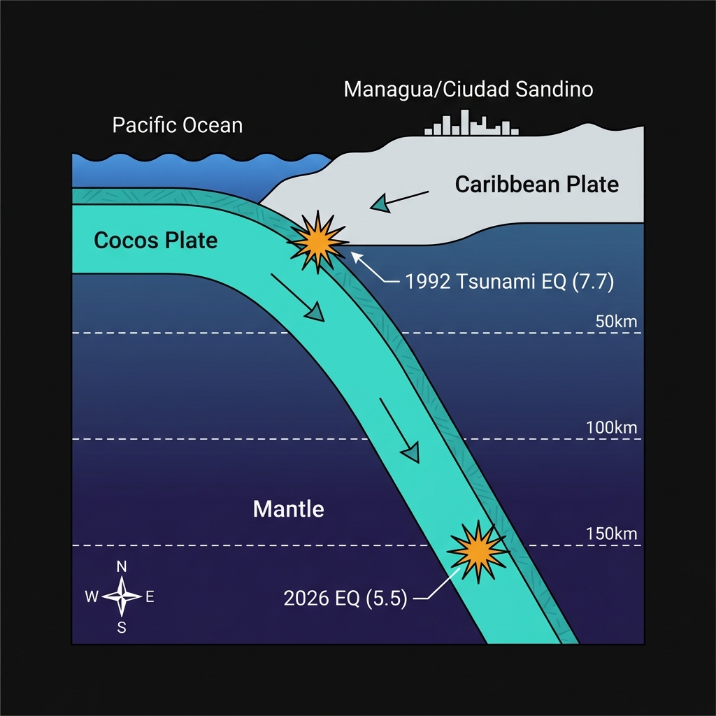
Nicaragua sits astride one of the planet’s most active tectonic boundaries, where the oceanic Cocos Plate grinds northeastward at roughly the rate fingernails grow, diving beneath the Caribbean Plate along the Middle America Trench. This subduction zone has sculpted Central America’s rugged spine and periodically unleashes its stored elastic energy in dramatic fashion. The historical record speaks in seismic shouts: the 1992 magnitude 7.7 event that triggered devastating tsunamis along the Pacific coast, the 2004 magnitude 7.0 quake that rattled Masachapa, and the 1996 magnitude 6.7 tremor that struck just 48 kilometers from today’s epicenter near Villa El Carmen. These events remind residents that they live above a geological vise, where an entire oceanic plate is slowly disappearing into the mantle’s furnace.
| Historical Event | Year | Magnitude | Distance from Ciudad Sandino |
|---|---|---|---|
| Corinto Tsunami | 1992 | 7.7 | 111 km |
| Masachapa Quake | 2004 | 7.0 | 82 km |
| La Conquista Event | 1990 | 6.8 | 77 km |
| Villa El Carmen | 1996 | 6.7 | 48 km |
| Today’s Event | 2026 | 5.5 | — |
Yet not all subduction earthquakes are created equal. Seismologists distinguish between the shallow, locked interface earthquakes—like the 1992 tsunami-generating monster that ruptured the plate boundary near the surface—and deeper events occurring within the descending slab itself. Today’s earthquake belongs to this latter category, originating well below the brittle crust where rocks typically fracture. At 155.7 kilometers depth, this tremor occurred within the subducted Cocos Plate, now so hot and pressurized that it bends and breaks in ways that send seismic waves efficiently through the surrounding mantle but dampen their destructive potential at the surface. This event represents the largest of two seismic occurrences recorded in the region over the past week, suggesting ongoing adjustments within the descending slab rather than renewed movement along the shallow plate interface.
What Does This Depth Mean for Those on the Surface?
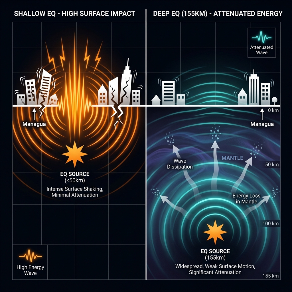
To understand why a magnitude 5.5 earthquake at 155 kilometers depth feels different from a similar-strength shallow quake, imagine shouting through a mattress versus across an open room. Seismologists classify earthquakes between 70 and 300 kilometers as “intermediate-depth” events, and they behave like distant thunder—audible over vast areas but rarely damaging. The energy must travel upward through nearly 100 miles of rock, dissipating as heat and friction before reaching Nicaraguan soil. Consequently, while the USGS received reports of light shaking across Managua’s metropolitan sprawl and as far as León, the intensity at the surface likely registered as a gentle rocking rather than the sharp, jarring jolts that topple buildings.
This depth also explains the absence of tsunami risk. Tsunamis require sudden vertical displacement of the seafloor, typically during shallow underwater earthquakes less than 50 kilometers deep. Because today’s event originated deep within the descending slab, far below the oceanic crust’s surface, no significant volume of water was displaced. The USGS tsunami alert system correctly indicated no hazard, distinguishing this deep-focus tremor from the shallow 1992 disaster that sent 10-meter waves crashing into coastal communities.
What Should We Watch For Next?
Deep earthquakes like this one rarely trigger destructive aftershock sequences, though the region will likely experience minor tremors as the crust adjusts to the sudden stress redistribution within the subducting slab. Seismologists will monitor whether this event represents an isolated adjustment or part of a broader stress transfer along the Middle America Trench. For residents, the takeaway is geological rather than immediately practical: Nicaragua’s subduction zone remains active across all depths, from the locked shallow interface capable of magnitude 8+ megathrust events to these deeper, slab-interior ruptures that serve as reminders of the ongoing recycling of oceanic lithosphere beneath their feet. GeoShake continues to track these signals, translating the deep Earth’s whispers into accessible science for a region that lives with the hum of tectonic engines.
Frequently Asked Questions
How strong was this earthquake?
The earthquake registered as magnitude 5.5 on the moment magnitude scale, a size that typically produces light to moderate shaking at the surface. However, because it originated at a depth of 155.7 kilometers, the energy had dissipated significantly before reaching Nicaragua’s cities, resulting in widely felt but generally non-damaging vibrations across the Managua region.
Is there a tsunami risk from this event?
No. The USGS indicates there is no tsunami threat from this earthquake. Tsunamis require vertical displacement of the seafloor during shallow underwater earthquakes, usually less than 50 kilometers deep. This event originated deep within the subducting Cocos Plate, far below the ocean floor, making it incapable of generating significant ocean waves.
Why is this area so seismically active?
Nicaragua sits above the Middle America Trench, where the Cocos Plate subducts beneath the Caribbean Plate at approximately 75 millimeters per year. This ongoing collision creates one of Central America’s most active seismic zones, capable of generating everything from deep mantle earthquakes like today’s event to shallow, destructive megathrust quakes such as the 1992 magnitude 7.7 tsunami earthquake.
Track this event live on the map!
Download GeoShake and get instant earthquake alerts.
Download GeoShake