A Sunday Afternoon Shudder
On a Sunday afternoon deep in the South Pacific, the seafloor shuddered. At 4:23 PM UTC, seismometers registered a magnitude 4.8 tremor roughly 131 kilometers southwest of Gataivai, a village on Samoa’s Savai’i island. The earthquake struck at a shallow depth of just 10 kilometers—shallow enough to send sharp seismic energy upward through the ocean crust without the damping effect of distance, yet far enough offshore that coastal villages likely felt only a gentle rumble or nothing at all. Still, for a region still bearing the physical and psychological scars of the devastating 2009 Samoa earthquake, any twitch of the tectonic plates commands attention.
The Tonga-Kermadec Pressure Cooker
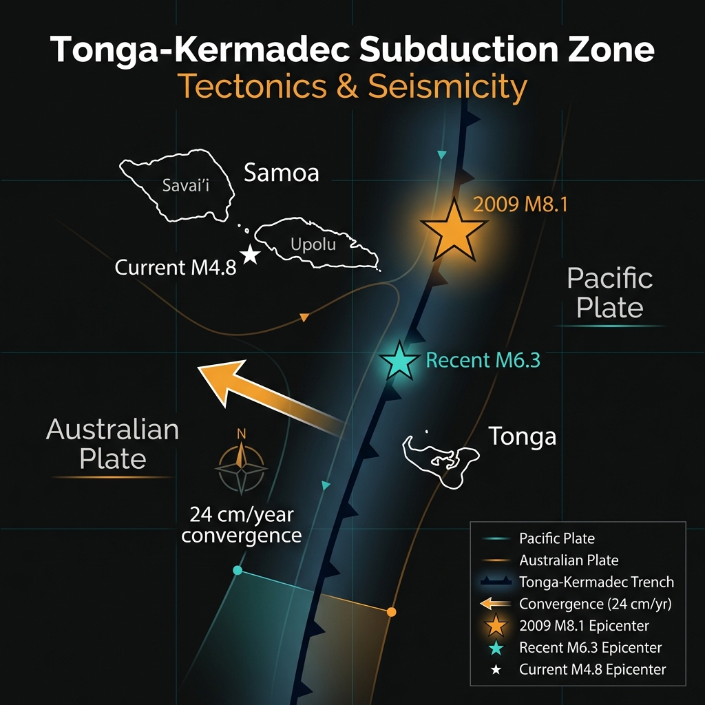
This patch of ocean sits astride one of the most aggressive meeting points on Earth: the Tonga-Kermadec subduction zone. Here, the Pacific Plate dives beneath the Australian Plate at a rate of roughly 24 centimeters per year—among the fastest convergence zones on the planet. The resulting trench system has produced some of the Pacific’s most powerful temblors, including the magnitude 8.1 Samoa earthquake of September 2009 that generated a deadly tsunami and claimed nearly 200 lives. That monster rupture occurred just 98 kilometers from today’s epicenter, a proximity that keeps seismologists particularly vigilant.
The area has not been quiet lately. Only days earlier, a magnitude 6.3 earthquake struck near Tonga, roughly 200 kilometers to the south, at the same shallow depth of 10 kilometers. This clustering is characteristic of the Tonga-Kermadec arc, where stress constantly accumulates along the megathrust fault interface—the boundary where one plate grinds beneath another. When seismologists see such shallow activity near historic rupture zones, they recognize it as the crust adjusting to persistent tectonic strain, though today’s M4.8 event remains far smaller than the zone is capable of unleashing. Looking back through four decades of records, this corner of the Pacific has repeatedly demonstrated its power, with significant magnitude 6.8 events recorded in both 2017 and 2022, and a violent magnitude 7.4 tremor in 1995.
Depth, Distance, and Everyday Comparisons
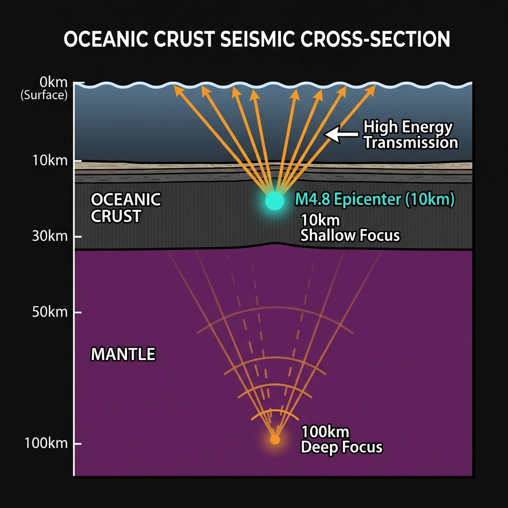
A magnitude 4.8 earthquake releases roughly the energy equivalent of 1,000 tons of TNT—powerful enough to rattle windows and disturb shelves if directly beneath a town, but diminished by distance. Given the offshore location, any shaking on Samoa’s islands would have been mild, likely registering as II to III on the Modified Mercalli Intensity scale: felt by few, noticed perhaps by sensitive individuals, causing no structural damage. The shallow depth—just 10 kilometers—meant the seismic waves did not have to travel far through the Earth’s interior before reaching the surface, preserving more of their punch than a deep-focus quake would at equivalent magnitude.
Seismologists classify this event using the body-wave magnitude scale (mb), which measures the amplitude of seismic waves traveling through the Earth’s interior rather than along its surface. For events of this size, mb provides a reliable snapshot of energy release, though it differs from the moment magnitude (Mw) used for the largest quakes. What makes this event geologically significant is not its immediate human impact—which appears negligible—but its position within an active sequence. When viewed against the historical record—featuring magnitude 6.6 to 7.4 events in the 1990s and the catastrophic M8.1 in 2009—today’s tremor fits a pattern of continuous, restless deformation rather than isolated incident.
Listening to the Earth
For the communities of Samoa and neighboring Tonga, these underwater rumblings serve as a geological heartbeat: constant, powerful, and occasionally terrifying. GeoShake monitoring indicates no tsunami threat from this particular event, but the swarm-like activity in the region, including last week’s M6.3, warrants continued observation. As the Pacific Plate continues its inexorable dive into the mantle, each tremor—whether a whisper like today’s M4.8 or the roar of a magnitude 8—offers fresh data about the forces building along the fault. In this corner of the Ring of Fire, the earth is speaking. Scientists are listening, watching to see whether these small adjustments remain just that, or signal something larger stirring in the deep.
Track this event live on the map!
Download GeoShake and get instant earthquake alerts.
Download GeoShake