
At 1:14 a.m. local time on April 5, 2026, the ground beneath Hualien City heaved once again. A magnitude 5.5 earthquake struck just 4 kilometers east-northeast of the city center, according to USGS data, placing the epicenter practically on the doorstep of Taiwan’s eastern coastal hub. The shallow rupture occurred within 20 kilometers of the devastating M7.4 quake that killed 18 people and damaged hundreds of buildings in April 2024, instantly raising alarms about structural integrity in a region still nursing its wounds.
Why Is This Area So Seismically Active?
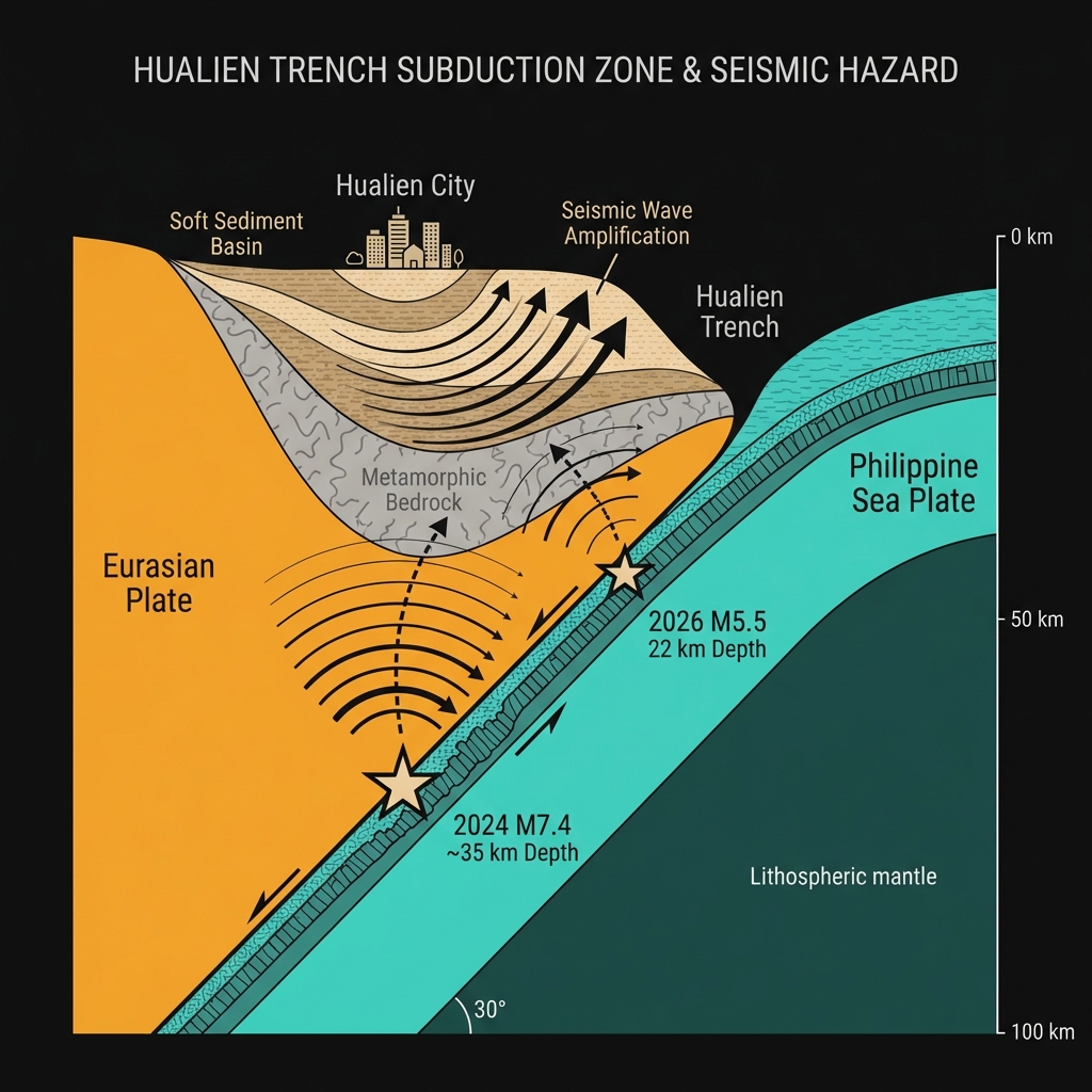
Hualien sits astride one of the most complex tectonic junctions on Earth. Here, the Philippine Sea Plate plunges beneath the Eurasian Plate in a relentless subduction process that builds Taiwan’s towering mountain ranges while storing elastic energy in the crust like a compressed spring. This particular earthquake originated at 22 kilometers depth, placing it within the brittle upper crust where the Philippine Sea Plate grinds against the Eurasian margin.
The region has hosted catastrophic ruptures before—the 2024 M7.4 event and the 1986 M7.4 quake both struck within 18 kilometers of today’s epicenter—revealing a persistent seismic hazard that transcends human memory. When these plates catch and release, the energy travels efficiently through the hard metamorphic rocks beneath Hualien. Unfortunately, the city itself sits atop younger, softer sediments that amplify seismic waves, subjecting buildings to stronger shaking than the bedrock experiences. This site amplification effect explains why moderate earthquakes near Hualien often cause disproportionate damage compared to similar events in rocky terrain.
How Strong Was the Shaking?
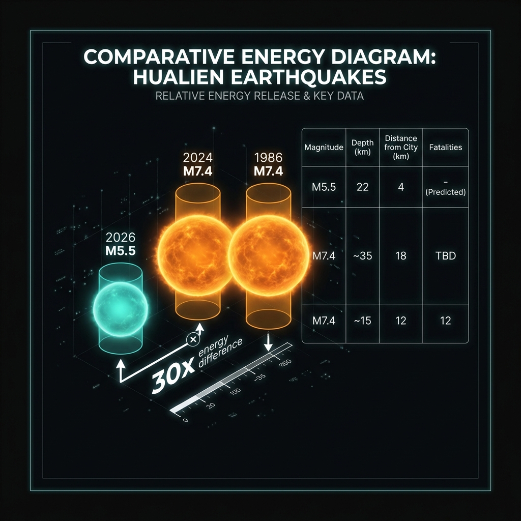
At magnitude 5.5, this earthquake packs roughly 30 times less energy than the 2024 disaster, yet its proximity to dense urban infrastructure changes the risk calculus entirely. Seismologists classify earthquakes between 5.0 and 5.9 as “moderate,” capable of causing significant damage to poorly constructed buildings within 10 to 20 kilometers of the epicenter. The 22-kilometer depth proves crucial here—deep enough to allow some dissipation of seismic waves before they reach the surface, yet shallow enough to produce sharp, jarring motion capable of toppling unsecured objects and cracking masonry.
Residents likely experienced intensity VI shaking on the Modified Mercalli scale in the immediate vicinity, meaning heavy furniture moved and plaster cracked, though well-built structures generally remained intact. The tremor was almost certainly felt across eastern Taiwan and possibly as far as Taipei, 120 kilometers to the northwest, though with diminishing intensity. This type of earthquake—a shallow crustal event near a major population center—represents exactly the scenario that keeps disaster planners awake at night, particularly when the rupture mechanism suggests stress redistribution following the 2024 mainshock.
Residents in Hualien should immediately inspect their homes for new cracks in load-bearing walls or foundations, particularly in structures damaged during the 2024 sequence. Check gas lines for leaks by smell only—never use open flames—and secure heavy furniture that may have shifted during the shaking. Those in coastal areas should note that while no tsunami warning was issued, ground subsidence or liquefaction in reclaimed land near the harbor requires vigilance during subsequent aftershocks.
What Happens Next?
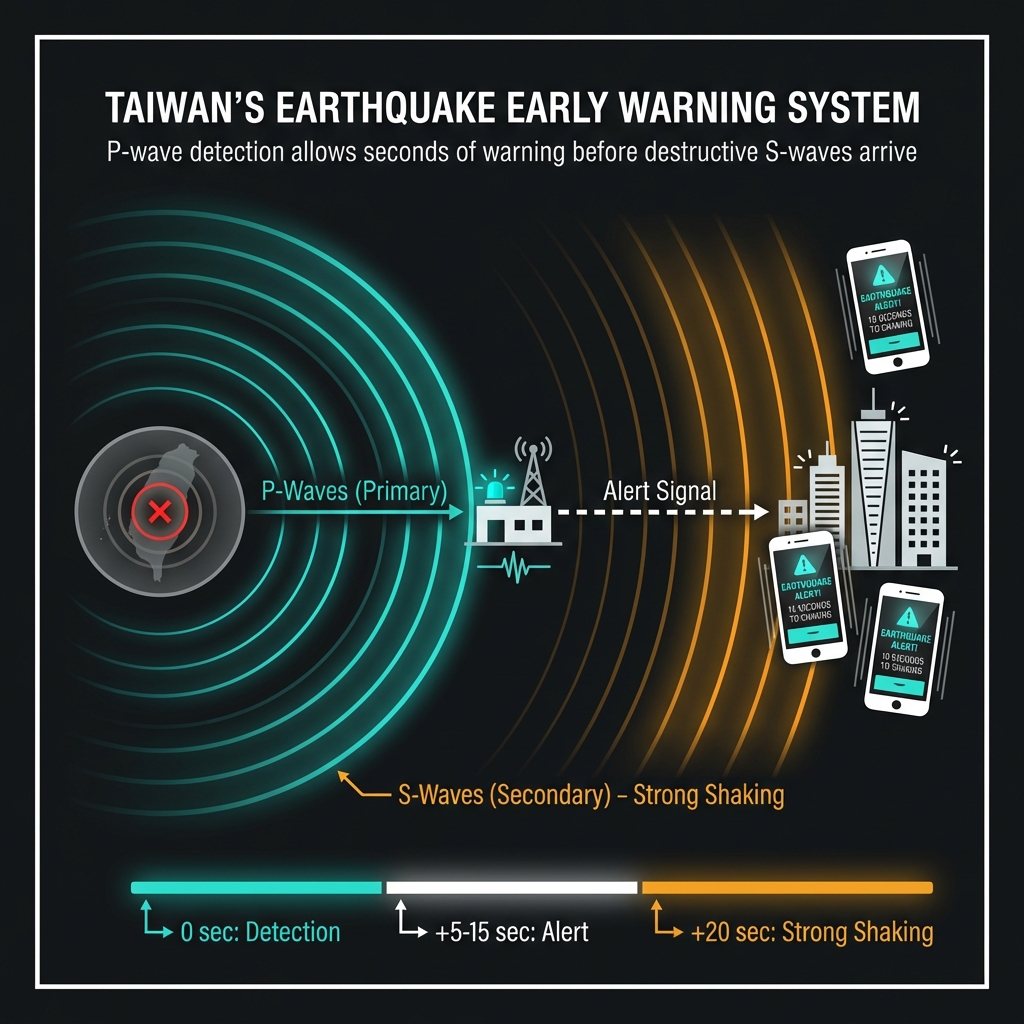
Seismologists will scrutinize the next 72 hours for aftershocks, which typically decrease in frequency while occasionally producing comparable or larger events within the first week. The proximity to the 2024 rupture zone suggests this could represent either continued stress adjustment from that sequence or the loading of adjacent fault segments previously left untouched. Taiwan’s Central Weather Administration maintains one of the world’s most advanced early warning systems, typically providing 5 to 15 seconds of alert before destructive S-waves arrive.
| Event | Magnitude | Distance from Hualien City | Depth | Fatalities |
|---|---|---|---|---|
| April 2026 | 5.5 | 4 km | 22 km | TBD |
| April 2024 | 7.4 | 18 km | ~35 km | 18 |
| November 1986 | 7.4 | 12 km | ~15 km | 13 |
GeoShake will continue monitoring swarm activity, particularly watching for any shallowing of hypocenters or migration toward the surface that might indicate escalating instability.
Frequently Asked Questions
How strong was this earthquake?
A magnitude 5.5 event releases approximately 2.8 petajoules of energy—enough to crack walls and displace heavy furniture but generally insufficient to destroy modern, earthquake-resistant buildings. The shaking intensity likely reached VI on the Modified Mercalli scale in downtown Hualien, meaning plaster cracked and objects fell from shelves, though structural collapse remained unlikely in code-compliant construction.
Is there a tsunami risk?
No tsunami warning has been issued for this event. The magnitude falls below the M7.0 threshold typically required to displace large volumes of ocean water, and the epicenter’s inland proximity—4 kilometers from the coast—further reduces tsunami potential. However, residents near the harbor should watch for localized seiche effects or unusual currents in the hours following the quake.
Why is this area so seismically active?
Hualien occupies the collision zone between the Philippine Sea Plate and the Eurasian Plate, where relentless tectonic convergence builds Taiwan’s mountains and stores immense elastic strain in the crust. This specific location has hosted two magnitude 7.4 earthquakes within the past 40 years, making it one of the most hazardous urban corridors in the Pacific Ring of Fire.
Track this event live on the map!
Download GeoShake and get instant earthquake alerts.
Download GeoShake