
Just ten kilometers beneath the waves off Indonesia’s Sulawesi coast, the Earth’s crust slipped. At this depth—shallow enough that seismic waves lose little of their destructive potential before reaching the surface—a magnitude 5.0 earthquake struck at 4:39 AM UTC on March 26, 2026, approximately 94 kilometers east-northeast of Kendari, according to USGS data. The event, though moderate in magnitude, carried an intensity disproportionate to its size due to its proximity to the seafloor, echoing a region that has repeatedly demonstrated its capacity for far more violent releases.
Why Does This Corner of Indonesia Generate Such Powerful Shocks?
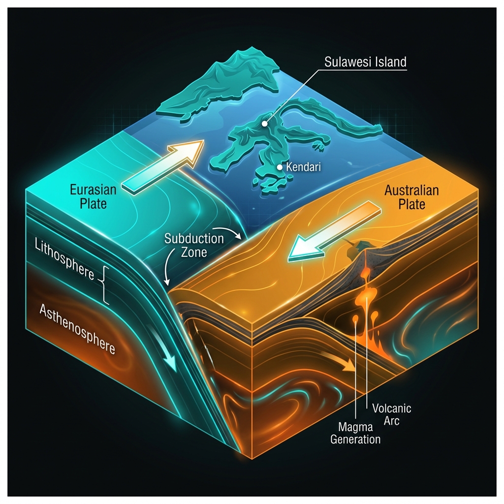
Sulawesi sits at a complex geological crossroads, caught between the converging Australian and Eurasian plates in a zone seismologists call the Banda Arc. Here, the dense oceanic floor of the Australian Plate is being subducted—forced beneath the lighter continental crust—in a slow-motion collision that stores elastic strain for decades before releasing it suddenly as an earthquake. This same tectonic machinery produced a devastating magnitude 7.5 temblor in 2001 just 77 kilometers from Thursday’s epicenter, proving that the faults beneath these waters are capable of generating significant destruction. The 2001 event, which ruptured at a depth of 77 kilometers, served as a stark reminder that this subduction zone can produce major earthquakes with relatively short recurrence intervals.
Historical records reveal this area is no stranger to significant shaking. In 2000, a magnitude 6.3 earthquake struck 66 kilometers from Kendari, while a magnitude 6.1 event occurred in 2011 roughly 114 kilometers away. These events cluster in a region where tectonic plates grind against one another, creating a seismic hotspot that makes shallow ruptures like Thursday’s particularly noteworthy for residents and scientists alike.
How Does Ten Kilometers Change the Way We Feel the Ground Move?
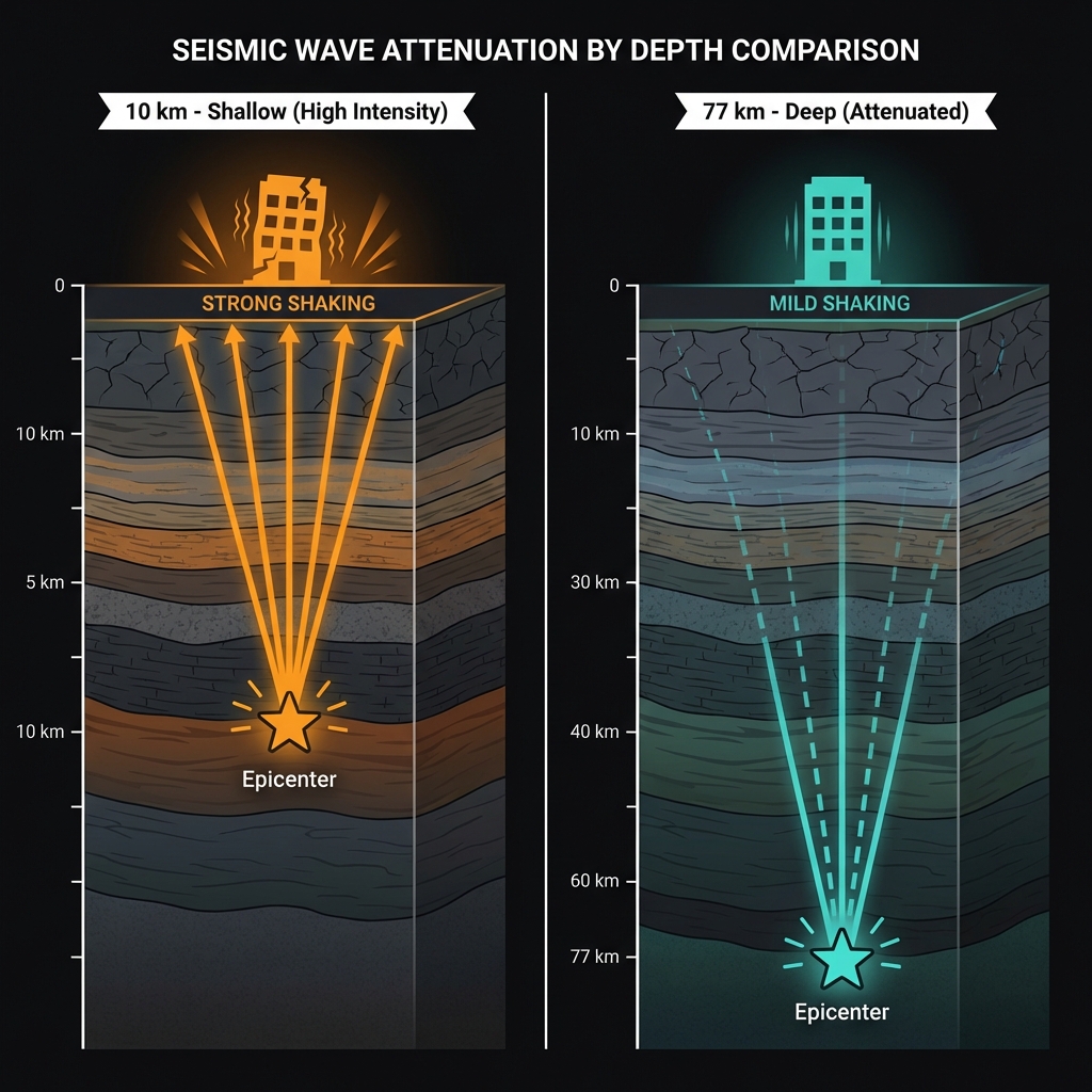
Depth is destiny in seismology. When an earthquake ruptures at ten kilometers—as this one did—the seismic waves travel only a short distance through the Earth’s crust before reaching the surface, arriving with most of their destructive potential intact. Seismologists classify this as a shallow crustal earthquake, and these events typically produce significantly stronger shaking than deeper quakes of equivalent magnitude because the energy hasn’t been absorbed by layers of rock. For context, ten kilometers is roughly the depth of the deepest gold mines on Earth, but in geological terms, it is skin-deep; most tectonic earthquakes originate between 10 and 30 kilometers down.
On the Modified Mercalli Intensity scale, a shallow M5.0 event typically produces shaking rated as “moderate” (V) to “strong” (VI) near the epicenter. This means residents may have experienced rattling dishes, disturbed furniture, and sensations similar to a heavy truck striking the building. While Thursday’s quake occurred offshore, the proximity to Kendari meant that coastal communities may have felt the tremor more sharply than they would have if the same magnitude had originated at the 77-kilometer depth of the 2001 disaster.
| Event | Year | Magnitude | Depth (km) | Distance from Kendari |
|---|---|---|---|---|
| Recent | 2026 | 5.0 | 10 | 94 km |
| 2001 | 2001 | 7.5 | 77 | 77 km |
| 2000 | 2000 | 6.3 | Not specified | 66 km |
| 2011 | 2011 | 6.1 | Not specified | 114 km |
Seismologists note that shallow earthquakes in subduction zones often indicate stress adjustments within the overriding plate rather than ruptures along the main subduction interface itself. This distinction is crucial for hazard assessment, as it suggests the event occurred within the brittle upper crust rather than along the deeper megathrust fault capable of generating magnitude 8.0+ earthquakes.
Are We Seeing a Pattern or Just Geology Continuing Its Work?
In the immediate aftermath, seismologists will monitor for aftershocks—smaller earthquakes that follow the main rupture as the crust adjusts to its new stress state. Given that this region has seen only this single significant event in the past week, Thursday’s quake appears to be an isolated release of stress rather than part of a developing swarm. However, the historical record suggests caution: the 2000 and 2001 events occurred within a year of each other, demonstrating that major stress releases can cluster in time.
GeoShake continues to monitor this sector of the Banda Arc, where the shallow depth of today’s event serves as a reminder that even modest magnitudes can pack a punch when the source sits just beneath the ocean floor. For now, the absence of a tsunami threat—confirmed by Pacific Tsunami Warning Center assessments—offers relief, though the proximity to shorelines always warrants vigilance in this subduction zone. Residents should remain prepared, as this region has proven time and again that it operates on geological timescales that do not respect human calendars.
Frequently Asked Questions
How strong was this earthquake?
A magnitude 5.0 earthquake is considered moderate. It is strong enough to be felt widely and may cause minor damage to poorly constructed buildings near the epicenter, but it is approximately 1,000 times less energetic than the magnitude 7.5 event that struck this region in 2001.
Is there a tsunami risk from this event?
No. According to USGS data, this earthquake did not generate a tsunami. The magnitude of 5.0 and the nature of the fault movement were insufficient to displace the water column significantly, and official tsunami warning centers did not issue alerts for this event.
Why is this area so seismically active?
The region sits at the boundary between the Australian and Eurasian tectonic plates, specifically within the complex Banda Arc subduction zone. Here, the Australian Plate is being forced beneath the Indonesian archipelago, creating immense pressure that periodically releases as earthquakes, ranging from moderate tremors like today’s to devastating magnitude 7.5+ events.
Track this event live on the map!
Download GeoShake and get instant earthquake alerts.
Download GeoShake