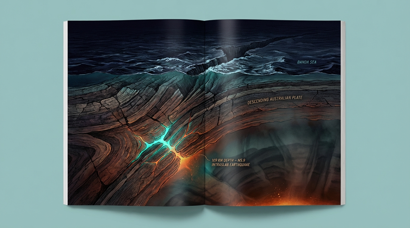
At 169 kilometers beneath the surface—deep enough to bury Mount Everest twice over with room to spare—a magnitude 5.9 earthquake ruptured within the Australian Plate on March 28, according to USGS data. The tremor struck just 30 kilometers from the epicenter of the devastating 2021 M7.3 earthquake that killed dozens and triggered a regional tsunami scare, yet this time no warning sirens sounded. The reason lies not in the magnitude, which was powerful enough to rattle buildings across Timor Leste, but in the earthquake’s intermediate depth, placing it within the subducting slab rather than the shallow crust where seafloor displacement generates tsunamis.
Why Is This Region a Seismic Pressure Cooker?
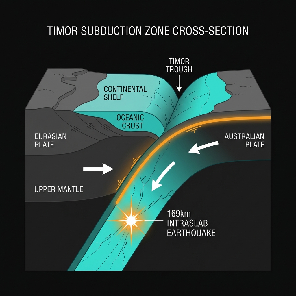
The Banda Sea and Timor region sits at the collision point of the Australian and Eurasian plates, where the oceanic Australian Plate dives beneath the continental shelf in a process called subduction. This collision created the Timor Trough, a deep submarine trench that marks the boundary between tectonic titans. As the Australian Plate descends into the mantle, it does not slide smoothly; instead, it shatters internally under immense heat and pressure, creating earthquakes within the slab itself.
The March 28 event represents one of these intraslab ruptures, occurring far below the seafloor interface that produced the catastrophic 2004 Indian Ocean tsunami. Historical records reveal this area’s violent temperament: since 1988, the region has experienced eight magnitude 6.5 or greater earthquakes within 200 kilometers of this latest event. The 2016 M6.7 tremor struck just 9 kilometers from Friday’s epicenter, while the devastating 2021 M7.3 shallow earthquake ruptured roughly 30 kilometers away, killing at least three people and damaging thousands of homes across Timor Leste and Indonesia.
What Does 169 Kilometers of Depth Mean for People on the Surface?
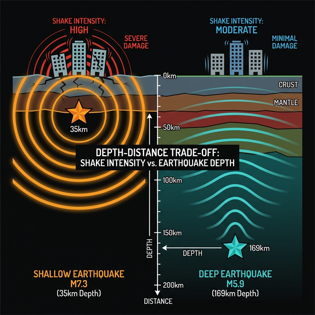
Depth transforms everything about how an earthquake feels. Seismologists classify earthquakes between 70 and 300 kilometers as “intermediate depth,” and these deep ruptures dissipate their energy through overlying rock before reaching the surface. While a shallow M5.9 might produce violent shaking capable of damaging poorly constructed buildings, this deep event generated rolling motions felt hundreds of kilometers away but with significantly less destructive potential at the epicenter.
The energy traveled upward through 169 kilometers of the Australian Plate’s interior, attenuating with every kilometer, unlike the 2021 M7.3 event, which ruptured at roughly 35 kilometers depth—shallow enough to thrust the seafloor upward and send tsunami waves racing toward coastal communities. This type of earthquake tells us about the internal stresses within the descending slab rather than the friction between tectonic plates at the megathrust boundary.
| Feature | March 28, 2026 Event | December 2021 Event |
|---|---|---|
| Magnitude | 5.9 | 7.3 |
| Depth | 169 km | ~35 km (shallow) |
| Distance from Lospalos | 144 km NE | 125 km NNE |
| Tsunami Generated | No | Small tsunami observed |
| Tectonic Setting | Intraslab (within subducting plate) | Megathrust/shallow crust |
The contrast illustrates what seismologists call the “depth-distance trade-off.” Friday’s quake released roughly 125 times less energy than the 2021 event, according to standard magnitude-energy relationships, and that energy had five times more rock to penetrate before reaching human settlements. Residents in Dili, the capital located approximately 200 kilometers southwest, likely felt the tremor as a gentle sway rather than a sharp jolt, while the 2021 earthquake sent people fleeing into the streets and damaged critical infrastructure across the island.
What Should We Watch For Now?
Deep earthquakes within subducting slabs rarely trigger significant aftershock sequences compared to their shallow counterparts, and the USGS indicates no tsunami threat from this event. However, the proximity to the 2021 rupture zone raises important questions about stress transfer between the shallow megathrust interface and the deeper slab interior. Seismologists will monitor whether this deep rupture indicates increased stress on the shallower plate boundary, where the potential for a destructive tsunami-generating earthquake remains ever-present. For now, the region returns to its normal state of seismic vigilance, with GeoShake and international networks continuing to track the slow, relentless descent of the Australian Plate into Earth’s interior.
Frequently Asked Questions
How strong was this earthquake?
The earthquake registered as magnitude 5.9 on the moment magnitude scale, a measurement that reflects the total energy released during the rupture. While this classifies as a moderate-to-strong earthquake, the event’s intermediate depth of 169 kilometers significantly reduced the intensity of shaking experienced at the surface compared to a shallow quake of similar magnitude.
Was there a tsunami risk?
No tsunami warning was issued because the earthquake occurred deep within the subducting Australian Plate rather than at the shallow seafloor interface. Tsunamis require vertical displacement of the ocean floor, typically caused by shallow earthquakes or underwater landslides, whereas this event’s energy dissipated through over 100 kilometers of solid rock before reaching the seabed.
Why does Timor Leste experience so many earthquakes?
The region sits at the active collision zone between the Australian and Eurasian tectonic plates, where the oceanic Australian Plate is forced beneath the continental Timor microplate in a subduction zone. This process generates frequent earthquakes both at the plate interface and within the descending slab itself, making Timor Leste one of the most seismically active areas in Southeast Asia.
Track this event live on the map!
Download GeoShake and get instant earthquake alerts.
Download GeoShake