
Just 35 kilometers from the palm-fringed shores of Luganville, Vanuatu’s second-largest city, the earth ruptured with the force of a magnitude 7.3 earthquake. Yet despite the proximity to a population center and the raw power of the release, the Pacific Tsunami Warning Center issued no alert, and coastal residents remained safe from the ocean’s surge. The reason lies nearly 116 kilometers straight down, according to USGS data, where the quake originated deep within the planet’s rigid interior rather than the seabed itself, robbing the rupture of the vertical lift needed to displace a deadly wall of water.
Why Is This Region a Hotbed of Deep Tremors?
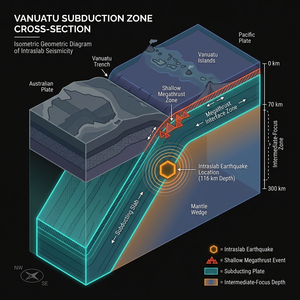
Vanuatu sits astride one of the most active tectonic collisions on Earth. Here, the Australian Plate grinds northward at roughly the speed fingernails grow, diving beneath the lighter Pacific Plate in a process geologists call subduction. This collision doesn’t happen gently; as the oceanic slab descends into the mantle, it warps, cracks, and occasionally snaps, releasing stored elastic energy as earthquakes.
The March 30 tremor represents exactly this type of intraslab event, occurring within the descending Australian Plate rather than at the shallow interface where the two plates meet. Seismologists classify earthquakes at these depths—between 70 and 300 kilometers—as intermediate-focus events, distinguishing them from shallow crustal quakes that typically inflict the most surface damage. This particular rupture struck at 115.8 kilometers depth, placing it squarely within the subducting slab’s brittle core, where temperatures and pressures remain low enough for rock to fracture suddenly.
Historical records reveal this isn’t the first time Espiritu Santo island has felt such a deep jolt. In 1990, a magnitude 7.2 earthquake struck just 37 kilometers east-northeast of Luganville, nearly mirroring the location and depth of today’s event. The region has hosted at least ten significant earthquakes exceeding magnitude 7.0 within a 200-kilometer radius over the past four decades, including a magnitude 7.5 event in 1999 located 152 kilometers to the southeast. This relentless activity stems from the continuous conveyor belt of subduction, which transports the Australian Plate deeper into the mantle at a rate of approximately 100 millimeters per year.
What Does 116 Kilometers Mean for Those on the Surface?
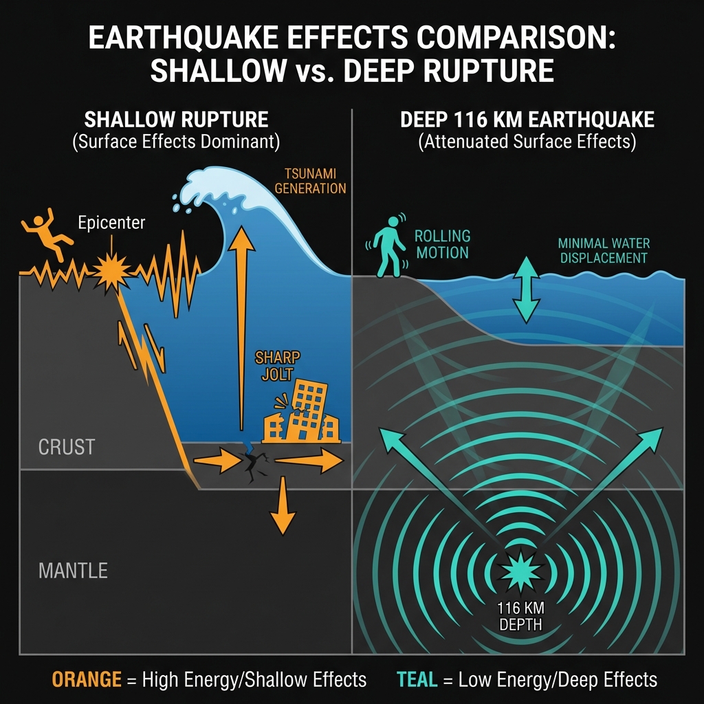
Depth acts as a natural buffer, but it doesn’t eliminate danger entirely. When an earthquake originates 116 kilometers below the surface, seismic waves must travel upward through the earth’s crust, dissipating energy along the way. This distance reduces the intensity of shaking at the surface compared to a shallow quake of identical magnitude, though the sensation remains unmistakable and potentially damaging.
For residents of Luganville and the surrounding communities on Espiritu Santo, the shaking likely felt like a rolling motion rather than a sharp jolt, characteristic of energy arriving from depth. The USGS estimates that such an event could produce modified Mercalli intensity levels of VI to VII near the epicenter, strong enough to crack plaster, dislodge heavy furniture, and alarm the population significantly. However, the energy spreads over a wider area than it would from a shallow rupture, meaning lighter shaking might have been perceptible on neighboring islands across the Vanuatu archipelago.
The depth also explains the absence of tsunami generation. Tsunamis require sudden vertical displacement of the seafloor, typically when shallow earthquakes thrust the ocean bottom upward or downward by several meters. At 116 kilometers depth, the rupture occurred far beneath the seafloor, within the solid rock of the descending slab. While the earthquake released tremendous energy—equivalent to several hundred kilotons of TNT—the motion failed to transfer efficiently to the overlying water column, preventing the formation of ocean-crossing waves.
What Should We Watch For in the Coming Days?
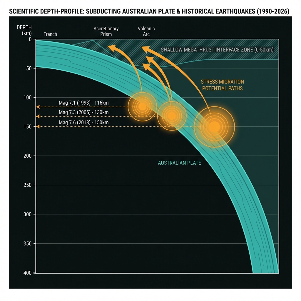
Deep earthquakes typically produce fewer aftershocks than their shallow counterparts, but the region will likely experience a sequence of smaller tremors as the crust adjusts to the stress redistribution. Seismologists monitoring the Vanuatu Trench will pay close attention to any migration of activity toward shallower depths, which could indicate stress transfer to the megathrust interface—the boundary where the Australian and Pacific plates actually touch.
Comparing this event to historical neighbors reveals a pattern of deep, powerful ruptures in this specific segment of the arc:
| Event | Year | Magnitude | Distance from Luganville | Depth (km) |
|---|---|---|---|---|
| 2026 Luganville | 2026 | 7.3 | 35 km NE | ~116 |
| 1990 Luganville | 1990 | 7.2 | 37 km ENE | ~116* |
| 1999 Lakatoro | 1999 | 7.5 | 152 km SE | ~150* |
| 2023 Port-Olry | 2023 | 7.0 | 68 km NW | ~130* |
*Estimated depths based on typical intraslab events in region; exact values may vary slightly in historical catalogs.
This table illustrates that magnitude 7 events at intermediate depths represent a recurring character in Vanuatu’s seismic story rather than an anomaly. While the immediate tsunami threat has passed, communities should remain prepared for potential infrastructure impacts from aftershocks and remember that the same subduction zone capable of producing these deep events can also generate shallower, tsunami-capable ruptures along the trench itself.
Frequently Asked Questions
How strong was this earthquake?
The earthquake registered as magnitude 7.3 on the moment magnitude scale, a major event capable of causing serious damage had it occurred at shallow depth. The rupture released energy equivalent to roughly 500 kilotons of TNT, though its deep origin approximately 116 kilometers below the surface significantly dampened the shaking intensity experienced in Luganville.
Why didn’t this earthquake trigger a tsunami?
Tsunamis require abrupt vertical movement of the seafloor during shallow earthquakes, typically less than 50 kilometers deep. This event originated at 116 kilometers depth within the subducting Australian Plate, too far beneath the ocean bottom to displace the water column above it effectively, according to USGS data.
Is this area becoming more seismically active?
Not necessarily. While the magnitude 7.3 event is significant, it fits within the established pattern of intermediate-depth earthquakes along the Vanuatu subduction zone. The region has produced at least ten magnitude 7.0 or greater events within 200 kilometers of Luganville since 1990, indicating consistent tectonic stress release rather than an escalating trend.
Track this event live on the map!
Download GeoShake and get instant earthquake alerts.
Download GeoShake