
The earth shook again in the same offshore patch of Pacific seabed that shattered windows and nerves four years ago. On March 30, 2026, at 7:30 UTC, a magnitude 5.4 earthquake struck 58 kilometers southwest of Masachapa, Nicaragua, according to USGS data. Its epicenter landed just 17 kilometers from the destructive M6.6 quake that rattled the region in 2022, and roughly 60 kilometers from the site of the catastrophic 1992 tsunami earthquake that killed 170 people along these shores.
Why Does This Fault Keep Rupturing?
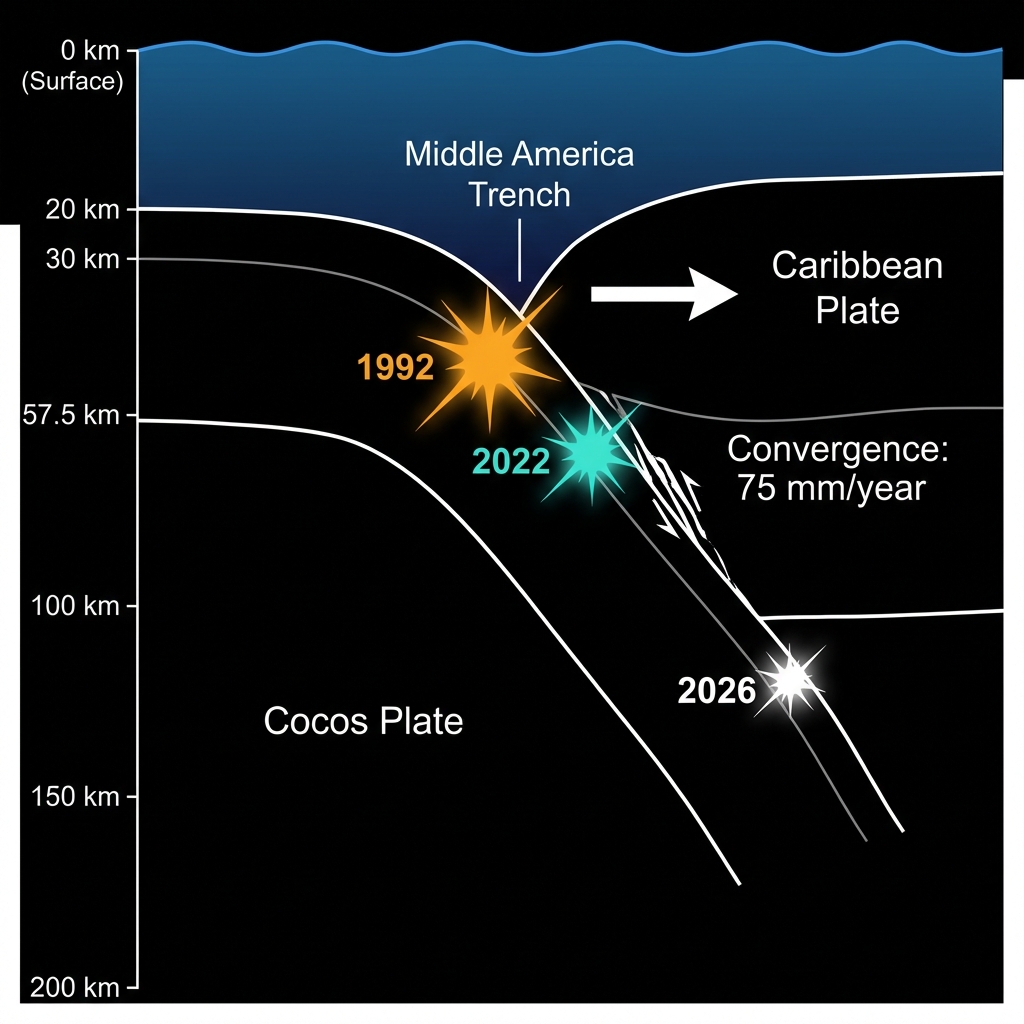
This is the Middle America Trench, a submarine graveyard where the dense Cocos Plate dives beneath the lighter Caribbean Plate at a pace of roughly 75 millimeters each year. That convergence builds immense strain. When the rock finally snaps, the seabed becomes a springboard for seismic energy.
Seismologists classify this region as a classic subduction zone, the same tectonic setting that produces the planet’s most powerful earthquakes. The trench has a violent memory. In 1992, a M7.7 earthquake struck 61 kilometers from this latest epicenter. That event was a “tsunami earthquake”—a slow, drawn-out rupture that generated disproportionately large waves relative to its magnitude, sweeping away coastal communities. Then in 2022, a M6.6 quake struck just 17 kilometers from Sunday’s location, causing significant regional damage and reminding residents that the fault segment remains locked and loading.
How Does Depth Change the Danger?
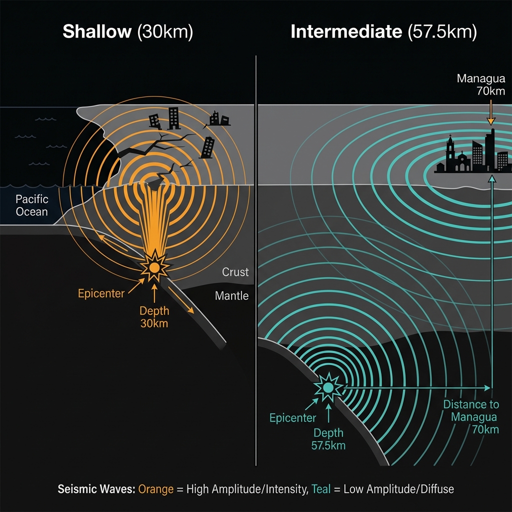
At 57.5 kilometers beneath the surface, this earthquake occurred at intermediate depth—far below the shallow crust but above the mantle’s ductile flow. Such depths often dampen the violent jolts felt at the surface, turning what might be a sharp crack into a rolling motion. Yet the energy still traveled efficiently through the rigid slab, likely sending perceptible shaking as far inland as Managua, 70 kilometers distant.
To grasp the scale, consider energy release. A magnitude 6.6 earthquake releases roughly 63 times more energy than a magnitude 5.4 event. The 2022 quake was a genuine regional shock; this latest tremor, while unsettling, was a fraction of that power. Still, depth matters as much as magnitude. Shallow quakes concentrate their punch near the epicenter, while intermediate-depth events like this one distribute their energy across broader areas, creating the “felt” radius that can startle cities far from the coast.
Recent activity suggests the region is restless. In the past week alone, three earthquakes have struck within 200 kilometers of Masachapa, including a M5.5 tremor near Ciudad Sandino. This clustering does not necessarily signal a larger event is imminent, but it underscores that the subduction zone is actively adjusting its stress fields.
| Event | Magnitude | Depth | Distance from Masachapa | Year |
|---|---|---|---|---|
| 1992 Tsunami Earthquake | 7.7 | ~20 km* | ~61 km | 1992 |
| 2022 Masachapa Quake | 6.6 | ~30 km* | 17 km | 2022 |
| March 2026 Event | 5.4 | 57.5 km | 58 km | 2026 |
| 2004 Offshore Quake | 7.0 | ~35 km* | 25 km | 2004 |
*Depths for historical events are approximate based on regional catalogs.
What Should We Watch For Now?
Aftershocks are possible but not guaranteed with intermediate-depth earthquakes, which tend to release their stress in single, isolated ruptures rather than the cascading sequences common to shallow crustal faults. Seismologists will monitor for weeks, watching whether this event represents a transient adjustment or the opening act of a swarm similar to the 1992 foreshock sequence. For now, the fault has spoken quietly—a reminder that the same segment capable of generating deadly tsunamis and damaging shocks remains poised beneath the waves.
Frequently Asked Questions
How strong was this earthquake?
The earthquake registered magnitude 5.4 on the moment magnitude scale, with an epicenter 58 kilometers southwest of Masachapa. At a depth of 57.5 kilometers, it produced light to moderate shaking near the coast and was likely felt in the capital, Managua, though significant damage was not expected.
Is there a tsunami risk?
No. According to USGS data, this event did not generate a tsunami. The earthquake’s intermediate depth of 57.5 kilometers and its distance from the trench margin reduced the vertical seafloor displacement necessary to displace a significant water column. Additionally, the magnitude—while noticeable—falls below the threshold typically associated with transoceanic tsunami generation.
Why is this area so seismically active?
The region sits atop the Middle America Trench, where the Cocos Plate subducts beneath the Caribbean Plate. This tectonic collision has produced multiple magnitude 7-plus earthquakes in recent decades, including the deadly 1992 tsunami earthquake and the damaging 2022 M6.6 event. The continuous convergence ensures that stress accumulates and releases regularly along this volatile boundary.
Track this event live on the map!
Download GeoShake and get instant earthquake alerts.
Download GeoShake