
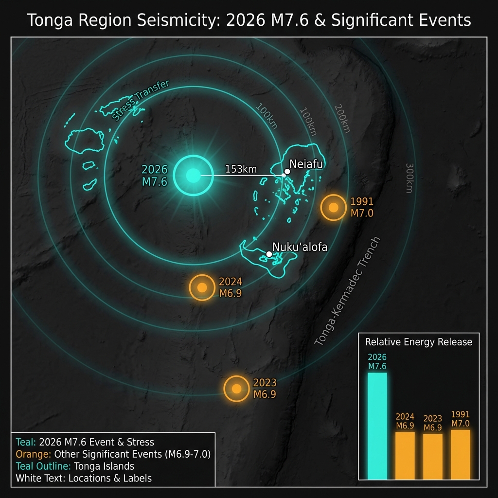
Two hundred thirty-seven kilometres beneath the cobalt surface of the South Pacific, the Earth slipped with devastating force. At 4:37 UTC on March 24, 2026, a magnitude 7.6 earthquake ruptured deep within the descending Pacific Plate, releasing energy equivalent to millions of tons of TNT yet leaving the ocean surface strangely calm. According to USGS data, this event—centered 153 kilometres west of Neiafu, Tonga—marks the region’s most powerful seismic disturbance in over three decades, a rare intermediate-depth temblor that demonstrated how depth can mute even the planet’s most violent convulsions.
Why Is This Subduction Zone So Seismically Active?
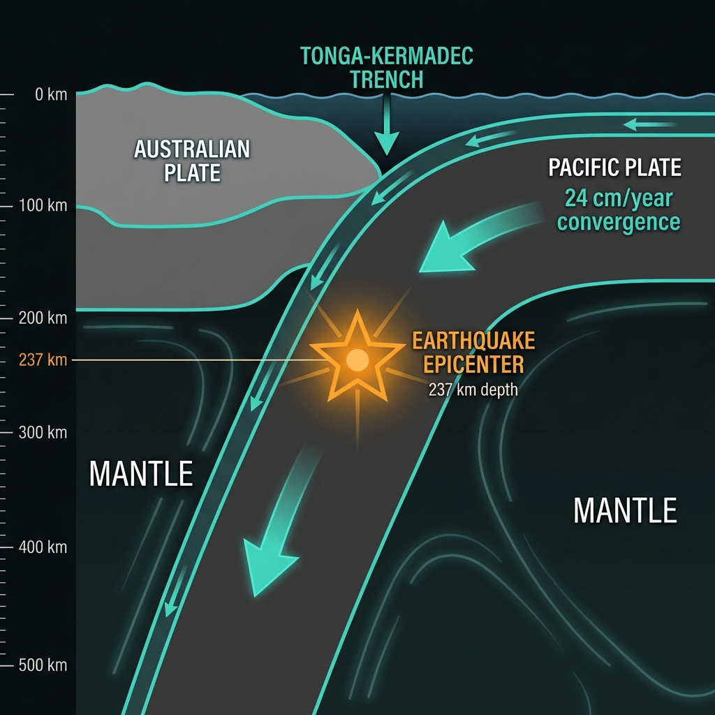
The Tonga Islands sit astride one of Earth’s most relentless geological conveyor belts. Here, the massive Pacific Plate dives westward beneath the Australian Plate at rates exceeding 24 centimetres per year—among the fastest subduction velocities on the planet. This collision creates the Tonga-Kermadec Trench, a 2,500-kilometre scar where oceanic crust is swallowed into the mantle. Seismologists classify this as a subduction zone earthquake, but the March 24 event occurred not at the shallow interface where plates grind together, but deep within the interior of the subducting slab itself. As the cold, brittle Pacific Plate descends into the hot mantle, it undergoes mineral transformations and internal cracking that can trigger these profound ruptures.
The region carries a heavy seismic memory. The last comparable event, a magnitude 7.0 quake in 1991, struck 191 kilometres northwest of the capital Nukuʻalofa. More recent history includes magnitude 6.6 to 6.9 events in 2019, 2023, and 2024, clustering west and northwest of Neiafu. Yet none matched the raw power of this deep-seated release, which reawakens questions about stress accumulation within the descending slab after decades of relative quiet.
How Does 237 Kilometres Change Everything?
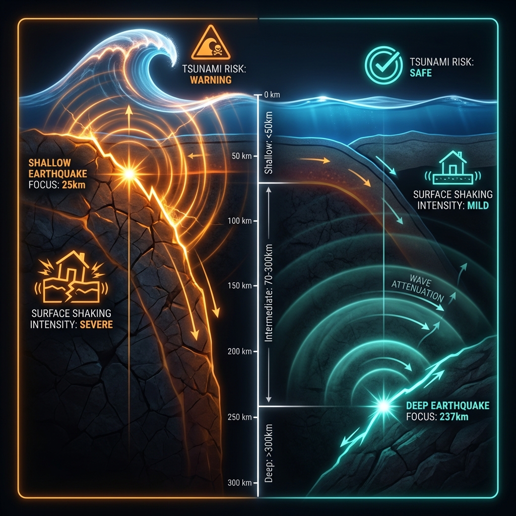
Depth is the great moderator of seismic destruction. When earthquakes strike within the first 50 kilometres of the crust—like the catastrophic 2011 Tōhoku event—they can displace vast volumes of water and unleash tsunamis while transmitting intense shaking to the surface. But at 237 kilometres down, the rupture sits nearly a quarter of the way through Earth’s mantle, separated from the seafloor by a cushion of rock that absorbs and dissipates seismic waves. This earthquake originated in what scientists call the intermediate-depth range, typically defined between 70 and 300 kilometres, where the subducting plate maintains enough rigidity to store elastic strain yet experiences enough heat to create complex failure mechanics.
The shaking reached the surface—residents of Neiafu likely felt a rolling motion rather than sharp jolts—but the energy dissipated across vast distances before arrival. Compare this to the region’s recent significant seismic history:
| Event | Year | Magnitude | Distance from Neiafu | Notable Characteristics |
|---|---|---|---|---|
| March 24 Mainshock | 2026 | 7.6 | 153 km west | Extreme depth (237 km); no tsunami generated |
| Offshore Tonga | 2024 | 6.9 | 129 km west | Moderate depth; local shaking reported |
| Northwest of Neiafu | 2023 | 6.9 | 105 km northwest | Shallow-intermediate; regional alert issued |
| Nukuʻalofa Region | 1991 | 7.0 | 191 km northwest | Previous record holder; shallower origin |
The 1991 event, despite being smaller in magnitude, likely produced more intense local shaking due to its shallower origin. Conversely, the 2026 earthquake’s extreme burial meant that by the time seismic waves reached Tongatapu or Vavaʻu, they had lost much of their destructive edge, preventing both structural devastation and tsunami generation despite releasing roughly 30 times more energy than the 2024 magnitude 6.9 event.
What Should Seismologists Watch For Next?
Deep earthquakes of this magnitude often reconfigure stress patterns across entire subduction zones, potentially triggering aftershocks at varying depths or even promoting shallower seismicity nearby. Seismologists will monitor the Pacific Plate’s descending slab for months to come, watching for smaller ruptures that might indicate continued adjustment within the stressed rock. While intermediate-depth events rarely produce tsunamis, they serve as critical reminders that Tonga’s geological foundation remains extraordinarily dynamic. For researchers, this earthquake offers a rare opportunity to study how energy propagates from such extreme depths through the complex mantle wedge above, data that could refine models of subduction zone hazards across the Pacific Ring of Fire.
Frequently Asked Questions
How strong was this earthquake?
The earthquake registered magnitude 7.6 according to USGS data, making it the most powerful event in the Tonga region since a magnitude 7.0 quake struck near Nukuʻalofa in 1991. At this magnitude, it released approximately 30 times more energy than a magnitude 6.6 event, though its extreme depth significantly reduced surface impacts.
Is there a tsunami risk?
No. Despite the earthquake’s considerable power, its depth of 237 kilometres prevented significant seafloor displacement. Tsunamis require vertical movement of the ocean floor, typically from shallow earthquakes less than 50 kilometres deep, where the rupture can directly push water upward. The substantial rock column above this deep event absorbed the motion before it could affect the surface.
Why is this area so seismically active?
The Tonga Islands sit above the Tonga-Kermadec subduction zone, where the Pacific Plate dives beneath the Australian Plate at one of Earth’s fastest convergence rates. This creates continuous stress as the cold oceanic slab descends into the hot mantle, generating earthquakes both at the plate interface and deep within the subducting crust itself, like the March 2026 event.
Track this event live on the map!
Download GeoShake and get instant earthquake alerts.
Download GeoShake