On a Friday evening in the Gulf of Alaska, the earth released another sigh of stress. At 6:23 PM local time, a magnitude 2.6 tremor rippled through the crust 36 kilometers east-northeast of Ouzinkie, a remote fishing village on Kodiak Island. To casual observers, the barely perceptible jolt might seem unremarkable—yet this shallow shake marked the 24th seismic event to rattle the region in just seven days, a persistent drumbeat of tectonic unrest along one of the planet’s most formidable fault systems.
The Subduction Zone Beneath
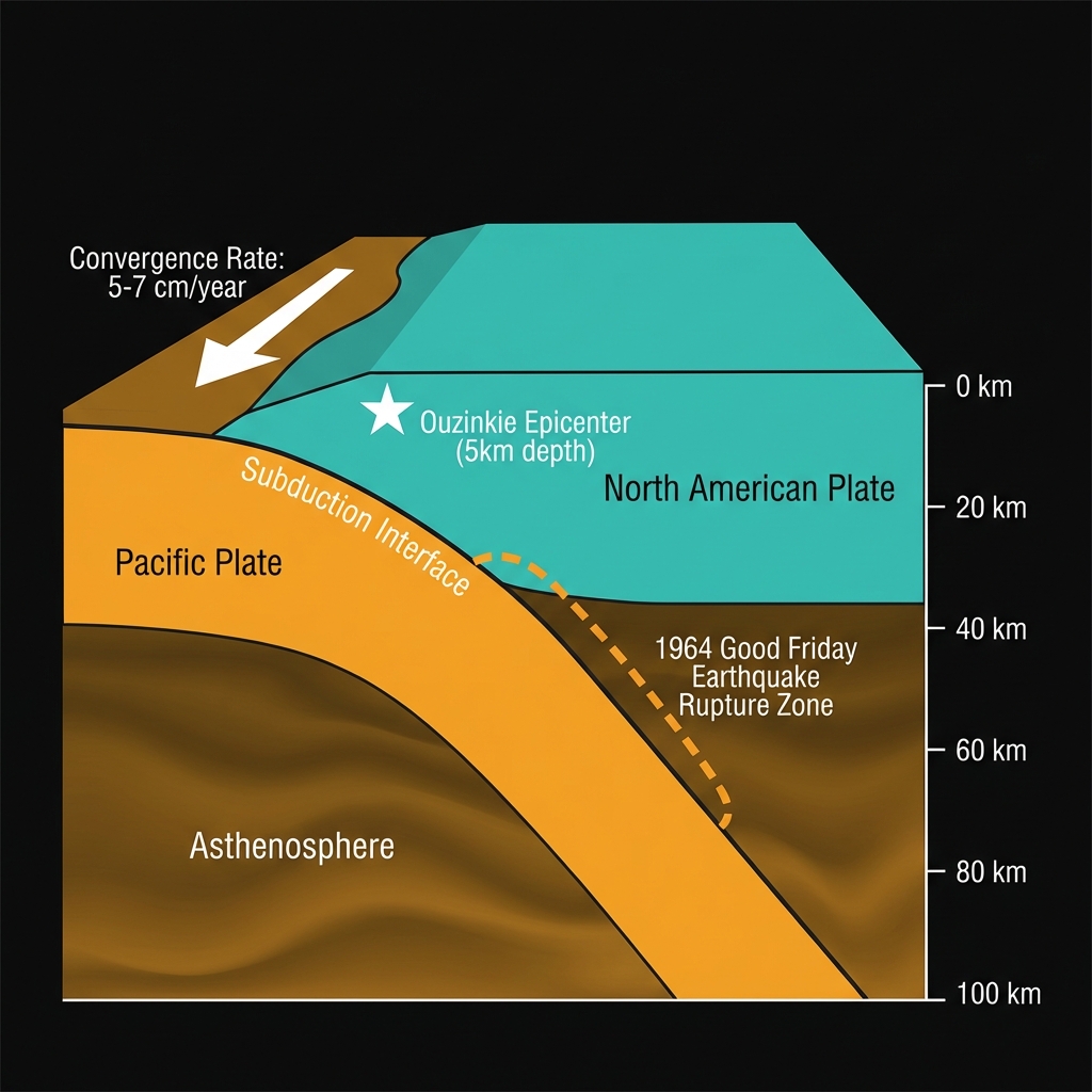
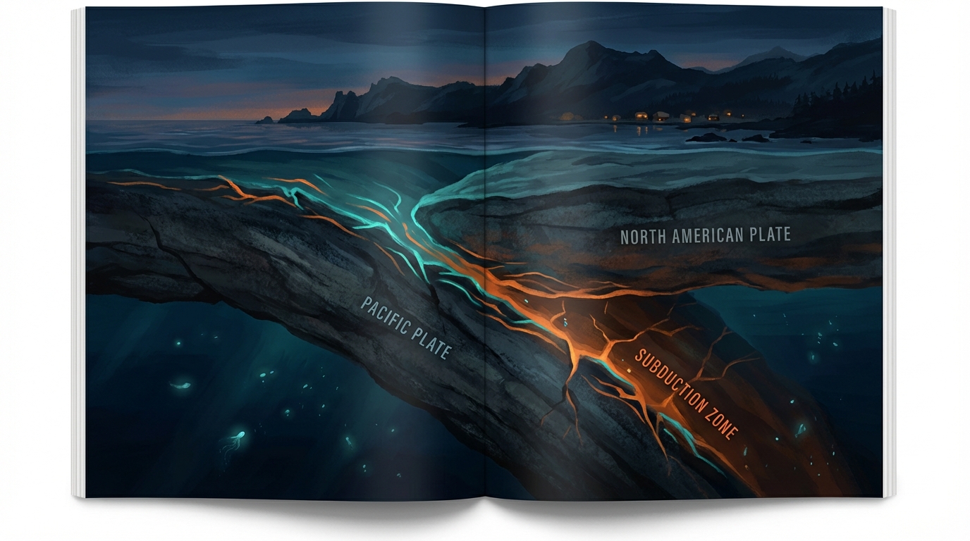
This cluster of earthquakes is unfolding along the Alaska-Aleutian subduction zone, a 4,000-kilometer geological seam where the Pacific Plate dives beneath the North American Plate at a rate of roughly five to seven centimeters per year—about the speed at which fingernails grow, but with infinitely more destructive potential. The zone represents a classic convergent boundary, where dense oceanic crust is forced into the mantle, building elastic strain that periodically releases in catastrophic fashion. Seismologists classify this as a “megathrust” environment, the same type of tectonic machinery that produced the 1964 Good Friday earthquake—at magnitude 9.2, the most powerful tremor ever recorded in North American history.
The current swarm sits near the eastern edge of this subduction interface, an area that has proven capable of significant ruptures. In January 2016, a magnitude 7.1 earthquake struck 47 kilometers east-southeast of Pedro Bay, roughly 187 kilometers from today’s epicenter, causing structural damage and reminding residents that even moderate-sized events carry consequence in this region. That tremor was preceded by a similar pattern of smaller foreshocks, a history that lends particular significance to the current sequence. The archives reveal a restless neighborhood: since 1999 alone, this stretch of the Aleutian arc has hosted multiple magnitude 6-plus events, including a M7.0 near Karluk in 1999 and a M6.9 south of Old Harbor in 2001, each releasing energy equivalent to hundreds of thousands of tons of TNT.
Reading the Tremors
Friday’s tremor originated at a depth of just five kilometers—shallow enough that the seismic energy had minimal rock to absorb it before reaching the surface. In practical terms, this meant that had the magnitude been larger, the shaking would have felt disproportionately intense for the number on the scale. As it was, the M2.6 event likely registered as a brief tremor or dull thud, comparable to the blast from a distant quarry or a heavy truck passing close by, noticeable only to those in the immediate vicinity of Ouzinkie and perhaps the broader Kodiak archipelago.
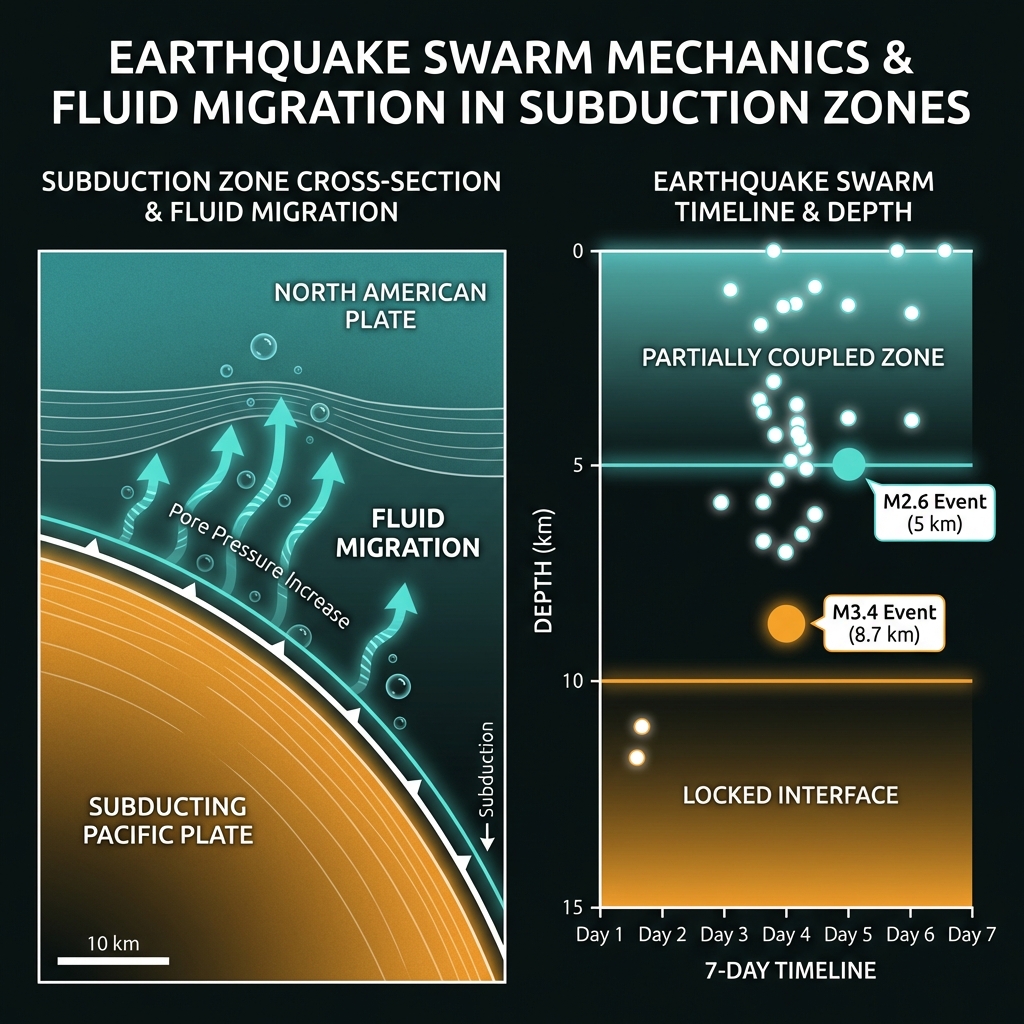
What distinguishes this event from routine background seismicity is its context within the week-long swarm. While individual magnitude 2 and 3 earthquakes are common along active subduction zones—thousands occur annually without consequence—the clustering of 24 events in seven days suggests a localized adjustment of crustal blocks rather than a standard mainshock-aftershock sequence. The largest of these recent tremors, a magnitude 3.4 that struck at a depth of roughly 8.7 kilometers near Kokhanok, remains modest, yet the frequency indicates the subduction interface is currently experiencing a phase of accelerated creep or fluid migration at depth. Seismologists note that such swarms often reflect the complex hydrogeology of subduction zones, where fluids trapped in the descending oceanic plate alter pore pressure within the overlying crust. When these fluids migrate upward through fractures, they can lubricate faults and trigger sequences of small earthquakes without the characteristic large “mainshock” that defines traditional aftershock patterns.
This type of earthquake swarm tells us that the Earth’s crust here is not locked in a simple binary of “stuck” versus “slipping,” but rather exists in a dynamic state of partial coupling, where sections of the plate interface slide episodically while others remain pinned, storing the elastic energy that eventually produces the region’s devastating magnitude 7-plus earthquakes.
The Bigger Picture
For residents of Kodiak Island, this week’s seismic chatter serves as a geological pulse check—a reminder that they live atop machinery of immense scale and power. While the current swarm lacks the signature patterns that would suggest an imminent major rupture, it underscores the importance of continuous monitoring along the Alaska-Aleutian margin. GeoShake’s sensors will continue tracking these micro-movements, parsing the difference between routine tectonic adjustment and potential precursory activity. In a region where the ground has proven capable of unleashing magnitude 7 earthquakes with little warning, even the smallest tremor carries a message written in the language of plate tectonics: the Earth is always speaking, and we are wise to listen.
Track this event live on the map!
Download GeoShake and get instant earthquake alerts.
Download GeoShake