
Ten kilometers beneath the rugged Pamir foothills, the earth convulsed with lethal proximity to the surface. At 10:26 UTC on April 3rd, a magnitude 5.5 earthquake ruptured just six miles below the terrain east of Rasht, Tajikistan, sending seismic waves rocketing upward with minimal attenuation to hammer nearby communities, according to USGS data. The tremor struck approximately 49 kilometers east-southeast of the city, a distance shallow enough to transform moderate tectonic energy into potentially destructive ground shaking for local populations.
Why Is This Region So Seismically Active?
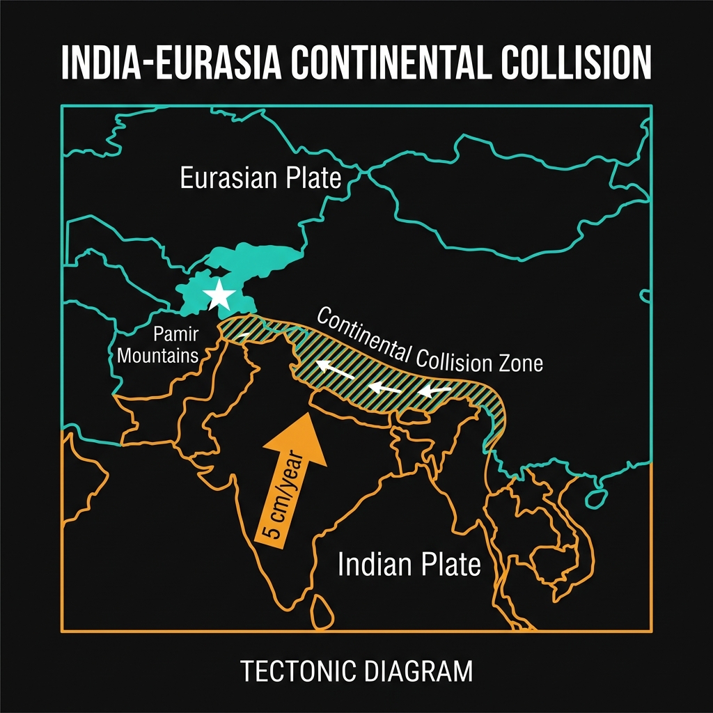
This restless corner of Central Asia marks the collision front between the Indian and Eurasian tectonic plates, a geologic battleground where continental crust crumples and uplifts the soaring Pamir Mountains. Here, the inexorable northward march of the Indian plate—moving roughly five centimeters annually—grinds against the rigid Eurasian landmass, storing immense elastic strain in shallow crustal faults that periodically rupture without warning.
The region bears the scars of recent devastation. In December 2015, a magnitude 7.2 earthquake struck 104 kilometers west of Murghob, approximately 179 kilometers from today’s epicenter, killing several people and destroying hundreds of homes across remote mountain villages. That event joined a cluster of significant tremors recorded in 2007 near Vorukh (M6.0), 2011 near Aydarken (M6.1), and 2017 near Karakenja (M6.0), illustrating a relentless seismic cadence. Seismologists classify these as shallow crustal earthquakes, occurring within the brittle upper 20 kilometers of the Earth where rocks break along steeply angled faults that translate directly into violent surface motion, unlike deep subduction zone quakes where energy dissipates through hundreds of kilometers of rock.
What Does This Depth Mean for Damaged Structures?
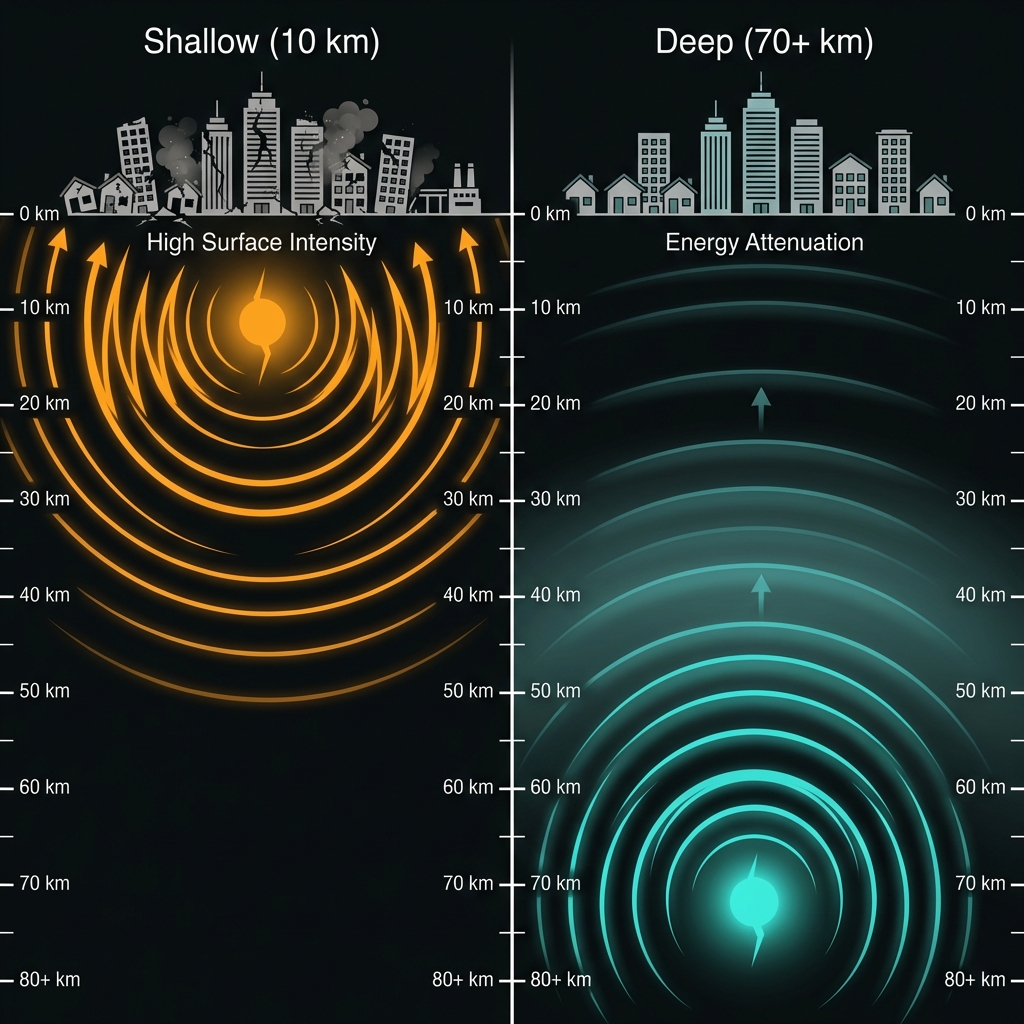
Depth determines devastation. Seismologists categorize earthquakes shallower than 70 kilometers as “crustal,” but today’s 10-kilometer rupture sits at the extreme shallow end—so close to the surface that seismic waves lose almost no energy to geological attenuation before reaching human infrastructure. A magnitude 5.5 event at this depth can produce Modified Mercalli Intensity shaking of VII (Very Strong) near the epicenter, capable of cracking masonry walls, toppling chimneys, and displacing heavy furniture.
The following table compares today’s event to significant historical earthquakes in the region:
| Event | Year | Magnitude | Approximate Depth | Distance from Rasht |
|---|---|---|---|---|
| Today’s earthquake | 2026 | 5.5 | 10 km | 49 km |
| Murghob earthquake | 2015 | 7.2 | ~26 km | 179 km |
| Karakenja earthquake | 2017 | 6.0 | ~15 km | 80 km |
| Vorukh earthquake | 2007 | 6.0 | ~33 km | 113 km |
This comparison reveals why today’s earthquake demands urgent attention despite its moderate magnitude. While the 2015 M7.2 event released roughly 250 times more energy, its greater depth and distance from population centers likely produced less intense shaking in Rasht than today’s shallow, nearby rupture. Residents likely experienced sharp, jarring motion lasting several seconds—potentially strong enough to damage adobe and unreinforced masonry structures common in the region—while perceptible tremors may have traveled as far as Dushanbe and across the Kyrgyzstan border.
For residents in the Rasht region and surrounding villages, immediate precautions are essential. Those occupying traditional mud-brick or stone masonry buildings should evacuate if they observe fresh cracks in walls, shifted door frames, or fallen plaster, as these symptoms indicate compromised structural integrity vulnerable to aftershocks. Given the mountainous terrain, families residing on steep slopes or near riverbanks must relocate to stable ground immediately, as shallow earthquakes frequently trigger rockfalls and landslides that can bury roads and homes without warning. Check liquefied petroleum gas connections for leaks—detectable by rotten egg odor or hissing—and shut off main valves only if accessible without entering damaged structures. Secure clean water supplies and prepare for potential isolation, as seismic activity often severs power and communication lines in this remote region.
What Should We Watch For?
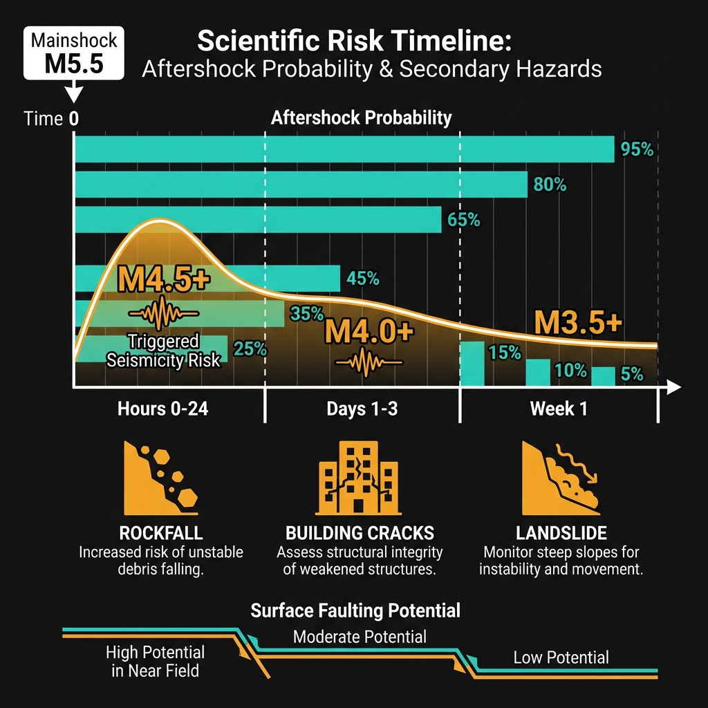
Seismologists will scrutinize this sequence for patterns of triggered seismicity along adjacent fault segments, particularly given the region’s demonstrated capacity for magnitude 7+ events. Aftershocks, potentially reaching magnitude 4.5 or higher, could strike within hours or days, further stressing buildings already damaged by the mainshock. GeoShake monitoring indicates no immediate suggestion of escalating activity toward the magnitude 7.2 scale of 2015, but the shallow depth of today’s rupture raises concerns about surface faulting and ongoing ground deformation in the epicentral region. Residents should maintain emergency supplies for at least 72 hours and avoid re-entering damaged structures until civil engineers complete safety assessments.
Frequently Asked Questions
How strong was this earthquake?
The earthquake registered magnitude 5.5, indicating a moderate release of tectonic energy. However, its extremely shallow depth of just 10 kilometers means the ground shaking near the epicenter likely reached intensity levels capable of damaging poorly constructed buildings, effectively making it feel significantly stronger than its magnitude alone would suggest.
Is there a tsunami risk?
No tsunami warning has been issued for this event. Tsunami generation requires substantial vertical displacement of the seafloor during underwater earthquakes, and this tremor occurred deep within the continental interior of Central Asia, hundreds of kilometers from the nearest ocean.
Why is this area so seismically active?
The region sits at the convergence zone between the Indian and Eurasian tectonic plates, where continuous continental collision generates intense compressional forces in the Earth’s crust. This tectonic pressure creates a complex network of shallow faults throughout the Pamir Mountains that frequently rupture, producing the cluster of magnitude 6+ earthquakes recorded in 2007, 2011, 2015, and 2017.
Track this event live on the map!
Download GeoShake and get instant earthquake alerts.
Download GeoShake