
At 6:22 PM local time on April 2, 2026, the ground beneath Sındırgı, a district in Turkey’s Balıkesir Province, jolted with a magnitude 4.2 tremor that sent residents into the streets and rattled nerves across the Aegean region. The earthquake struck at a shallow depth of just 10.6 kilometers beneath the surface, according to USGS data, placing it within the brittle upper crust where even modest magnitudes can produce surprisingly intense shaking.
Why Is This Region So Seismically Active?
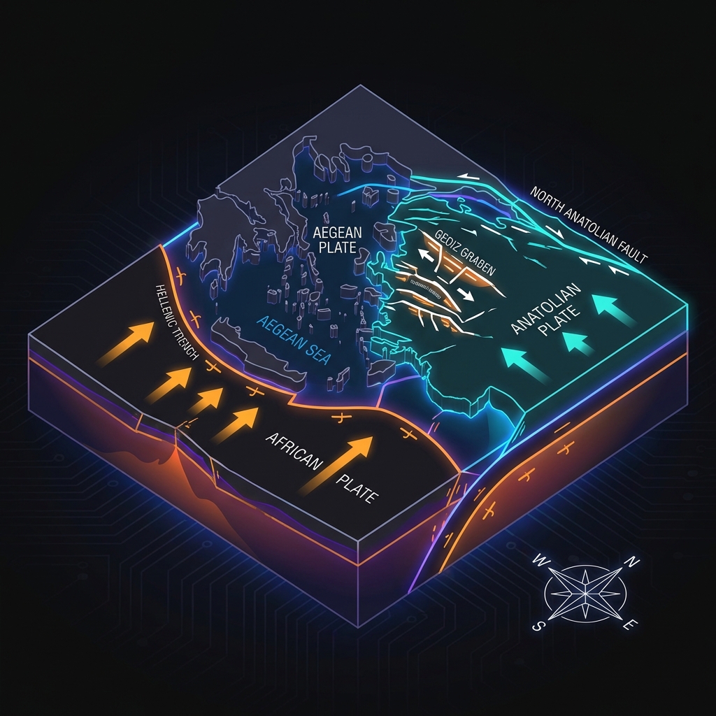
Western Turkey sits at the collision point of three tectonic giants: the Eurasian, African, and Anatolian plates. Here, the mechanics get complicated. As the African Plate subducts beneath the Aegean Sea, it drags the overlying crust downward, creating a suction effect that pulls the Anatolian Plate westward. This motion opens up a series of grabens—down-dropped valleys bounded by faults—across western Turkey. Sındırgı lies within this extensional province, where the Earth’s crust is being stretched north-south like warm toffee, breaking along normal faults that dip at angles and slip when stress accumulates.
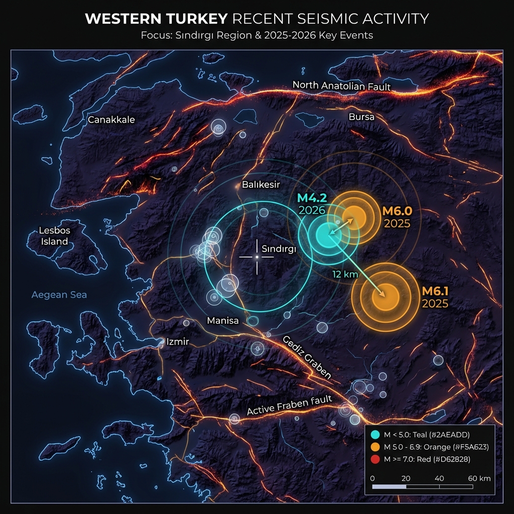
The seismic character of this area is not one of occasional massive ruptures but of persistent, scattered activity. The region has hosted 278 earthquakes in just the past week alone, suggesting the fault systems here remain in a state of near-constant adjustment. Historical records underscore this volatility: in 2025, a magnitude 6.0 earthquake struck just 12 kilometers southeast of Sındırgı—essentially the same neighborhood—while another magnitude 6.1 event hit 39 kilometers away near Bigadiç that same year. Going further back, the 1995 Dinar earthquake (magnitude 6.4) and the 2020 Aegean Sea event (magnitude 7.0) remind us that this region can generate destructive energy when deeper structures rupture.
What Does This Depth and Magnitude Mean?
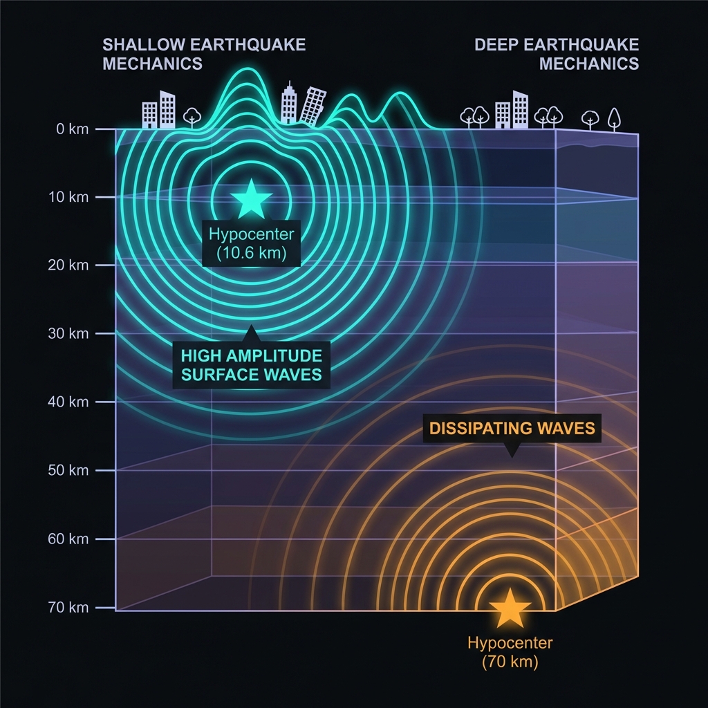
Ten and a half kilometers is shallow—very shallow. Seismologists classify earthquakes less than 70 kilometers deep as “shallow-focus,” but anything under 15 kilometers enters the realm where seismic waves haven’t dissipated much energy before reaching the surface. At this depth, a magnitude 4.2 event releases energy equivalent to roughly 1,000 tons of TNT, but the proximity to the surface amplifies the perceived intensity.
The shaking would have felt like a heavy truck colliding with a building or a sudden jolt from a major construction blast nearby. For residents of Sındırgı, the experience was likely a sharp, abrupt shock rather than a rolling motion, characteristic of shallow normal-faulting earthquakes. Reports suggest the tremor was felt across Balıkesir Province and potentially into neighboring Manisa, though the localized nature of shallow crustal events typically limits damage to a radius of 20-30 kilometers unless the magnitude exceeds 5.0.
How Does This Fit Into the Current Seismic Sequence?
This earthquake arrives amid an exceptionally active period for the region. The past seven days have seen nearly 280 seismic events within a 200-kilometer radius, indicating the crust is currently adjusting to stress changes across multiple fault segments. Seismologists classify this as swarm-like behavior—elevated seismicity without a single dominant mainshock—though the magnitude 4.2 event represents the largest in this recent sequence.
| Event | Magnitude | Distance from Sındırgı | Year |
|---|---|---|---|
| Sındırgı (today) | 4.2 MW | — | 2026 |
| Sındırgı | 6.0 | 12 km SE | 2025 |
| Bigadiç | 6.1 | 39 km WSW | 2025 |
| Marmara Ereğlisi | 6.2 | 189 km E | 2025 |
| Dinar | 6.4 | 195 km E | 1995 |
The proximity of the 2025 magnitude 6.0 event—just 12 kilometers away—is particularly noteworthy. Such clustering suggests these earthquakes may represent the ongoing relaxation of stress along a specific fault system or group of faults branching from the broader Gediz Graben structure. While today’s magnitude 4.2 event is significantly smaller, it occupies the same tectonic neighborhood and may reflect either aftershock activity from the 2025 event or independent rupture on a nearby fault strand.
What Should We Watch For Next?
In the coming days, the Sındırgı region will likely experience aftershocks—smaller earthquakes that follow the main rupture as the crust settles into a new equilibrium. While most aftershocks to a magnitude 4.2 event remain below magnitude 3.0, occasionally a similar-sized or slightly larger event can occur, particularly given the current high background seismicity. The AFAD and international monitoring networks will watch for any deviation from the expected decay pattern, which could signal either a new phase of activity or the approach of a larger rupture. For now, this event serves as a reminder that western Turkey’s extensional tectonics remain in constant motion, reshaping the landscape one earthquake at a time.
Frequently Asked Questions
How strong was this earthquake?
A magnitude 4.2 earthquake releases energy equivalent to approximately 1,000 tons of TNT. Because it occurred at a shallow depth of 10.6 kilometers, the shaking felt at the surface was more intense than deeper earthquakes of similar magnitude, producing a sharp jolt rather than rolling motion for residents near the epicenter.
Is there a risk of a tsunami?
No. The earthquake occurred inland, approximately 10.6 kilometers beneath the surface of the landmass, far from any coastline. Tsunamis require vertical displacement of the seafloor during submarine earthquakes, typically magnitude 7.0 or greater, to displace significant water volume.
Why is this area experiencing so many earthquakes recently?
The Sındırgı region sits within western Turkey’s Aegean extensional province, where the Earth’s crust is being stretched and thinned as the Anatolian Plate moves westward. This tectonic setting creates a network of active normal faults that generate frequent moderate earthquakes. The recent cluster of 278 events in seven days, combined with the magnitude 6.0 earthquake nearby in 2025, indicates this specific fault system remains highly stressed and actively releasing accumulated strain.
Track this event live on the map!
Download GeoShake and get instant earthquake alerts.
Download GeoShake