
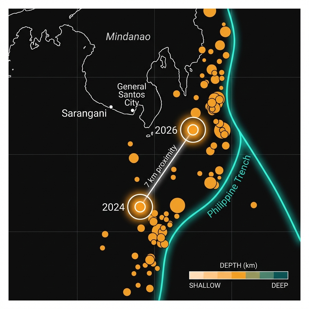
The ground shuddered beneath the southern Philippines on Friday morning with a geological sense of déjà vu. The magnitude 6.0 temblor that struck at 10:34 UTC occurred just seven kilometers from the epicenter of a powerful M6.7 earthquake that rattled the same waters in 2024, according to USGS data. This near-identical location, approximately 90 kilometers southeast of Sarangani, suggests the Philippine Trench is still adjusting its tectonic strain, releasing energy along the same volatile undersea fault system that arcs beneath the nation’s southern archipelago.
Why Is This Region So Seismically Active?
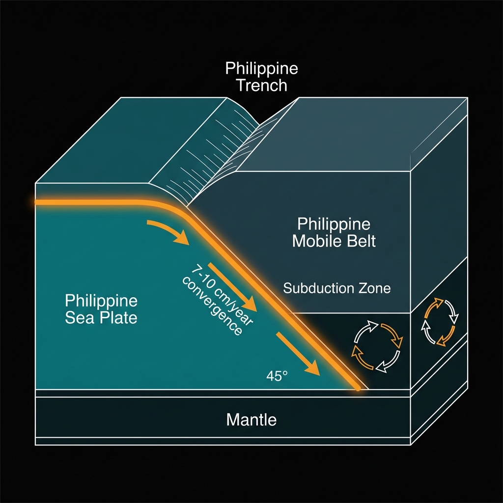
The Philippines sits astride one of Earth’s most complex tectonic collisions, where the Philippine Sea Plate dives beneath the Philippine Mobile Belt in a relentless process called subduction. This creates the Philippine Trench—a 1,400-kilometer scar on the ocean floor where immense slabs of oceanic crust grind against the continental margin at roughly seven to ten centimeters each year. As the cold, dense plate descends into the hot mantle, it warps, cracks, and occasionally snaps, generating earthquakes deep within the planet’s interior rather than at the surface.
The region’s seismic history reads like a catalog of significant tremors. Since 1987, at least ten magnitude 6.0 or greater earthquakes have struck within 200 kilometers of Friday’s epicenter, including a M7.2 in 2009 and three separate magnitude 7.0+ events between 2018 and 2021. Most notably, the November 2024 M6.7 event—the closest historical match to today’s quake—occurred at a depth of approximately 10 kilometers, making it significantly shallower and more locally destructive than Friday’s deeper rupture. The seven-kilometer horizontal distance between these two epicenters is less than the span of many small cities, suggesting they originate from the same structural zone within the descending slab.
What Does This Depth Mean for the Shaking?
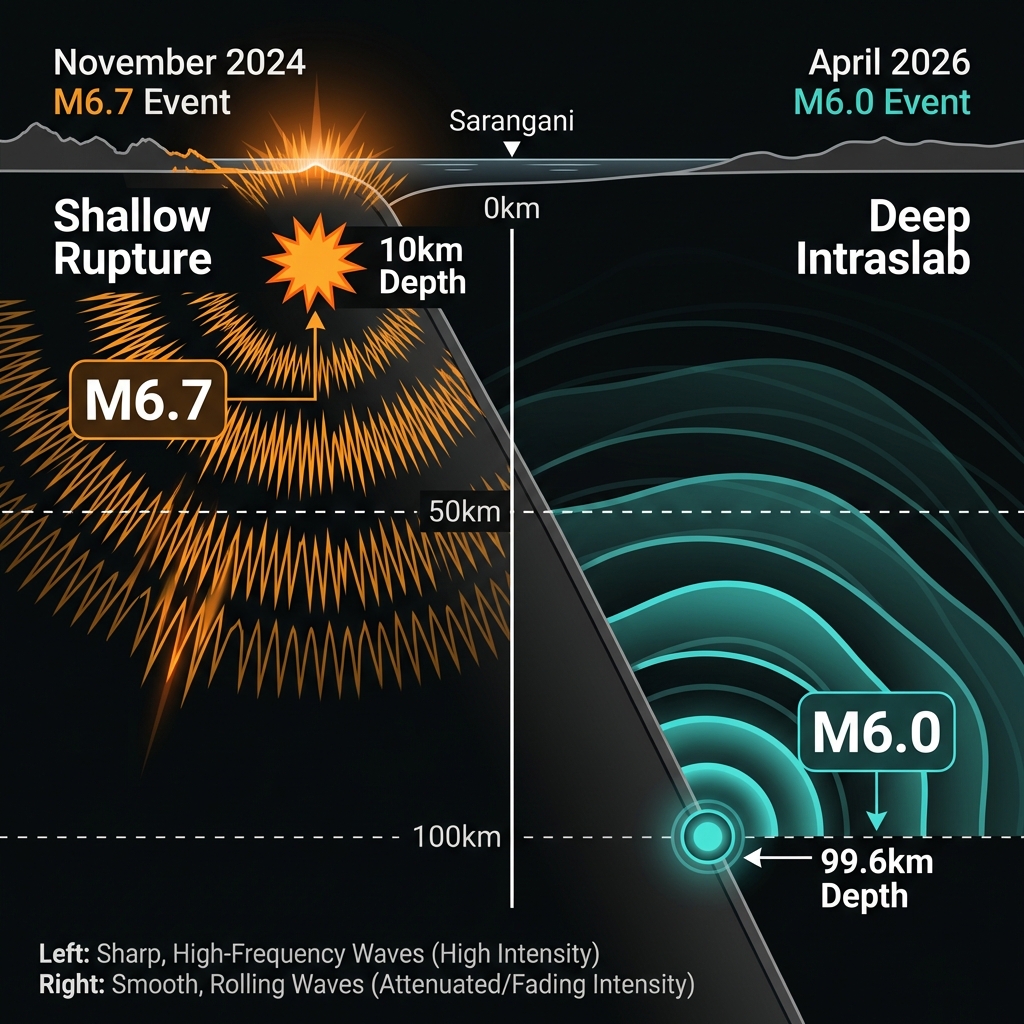
At 99.6 kilometers beneath the surface, Friday’s earthquake originated in the upper mantle, far below the seismogenic zone where most destructive quakes occur. Seismologists classify this as an intermediate-depth event, occurring within the descending Philippine Sea Plate rather than at the shallow plate interface where the greatest tsunami hazards typically develop. While a magnitude 6.0 release carries roughly the energy of 15,000 tons of TNT, the considerable depth meant the seismic waves had more rock to pass through before reaching the surface, attenuating their destructive potential through absorption and geometric spreading.
The shaking likely manifested as a gentle, rolling motion to coastal residents rather than the sharp, violent jarring typical of shallow crustal quakes. This distinction matters for building safety: structures designed to withstand horizontal acceleration from deep events often perform differently than when subjected to the high-frequency shaking of shallow ruptures. Comparisons to the 2024 event reveal telling differences in how depth and magnitude interact to create local intensity:
| Event | Magnitude | Depth | Distance from Coast | Character |
|---|---|---|---|---|
| April 2026 | 6.0 Mww | 99.6 km | 90 km SE of Sarangani | Deep, rolling, widely felt |
| November 2024 | 6.7 Mww | ~10 km* | 93 km SE of Sarangani | Shallow, sharp, locally damaging |
*Depth estimated based on typical shallow subduction zone earthquakes.
Despite the distance offshore, the earthquake was probably perceptible in General Santos City and coastal communities in Sarangani Province, though significant damage was unlikely given the depth and offshore location.
Seismologists classify this as an intraslab earthquake—a rupture within the descending plate itself rather than at the boundary between the two colliding plates. This distinction is crucial because intraslab events, while capable of widespread shaking, rarely generate tsunamis since they don’t displace the seafloor vertically. The proximity to the 2024 epicenter suggests these events represent the continued brittle failure of the same stressed section of the Philippine Sea Plate as it bends and sinks into the mantle. This clustering behavior tells us that specific portions of the descending slab can remain mechanically weak for years after initial rupture, creating seismic hotspots that light up repeatedly as the plate continues its descent.
What Should We Watch For Next?
While no tsunami threat materialized from this deep event, the recurrence of significant earthquakes in this specific patch of the trench warrants continued scrutiny. Seismologists will analyze whether stress from the 2024 shallow rupture may have triggered this deeper adjustment, or if both events represent independent failures of the same sinking slab segment. Residents should remain prepared for aftershocks, though these will likely be smaller and confined to similar depths. More importantly, this event serves as a reminder that the Philippine Trench can produce much larger megathrust earthquakes at shallower depths—events that would pose significant tsunami risks to the densely populated coastlines of Mindanao. Monitoring networks remain vigilant for any signs that stress is shifting toward the locked portions of the plate interface.
Frequently Asked Questions
How strong was this earthquake?
A magnitude 6.0 earthquake releases energy equivalent to approximately 15,000 tons of TNT. However, because this event occurred nearly 100 kilometers beneath the surface, the shaking felt on land was significantly weaker than the magnitude number alone might suggest, manifesting as a rolling motion rather than sharp jolts.
Is there a tsunami risk from this event?
No tsunami warning was issued for this earthquake. The USGS assessment indicated no tsunami risk because the event occurred too deep to cause significant vertical displacement of the seafloor, and its magnitude, while substantial, remained below the threshold typically associated with tsunami generation in this region.
Why is this area so seismically active?
The region lies along the Philippine Trench, where the Philippine Sea Plate subducts beneath the Philippine Islands at a rate of several centimeters per year. This convergent boundary creates continuous tectonic stress that releases periodically as earthquakes, making this one of the most earthquake-prone zones in the Pacific Ring of Fire.
Track this event live on the map!
Download GeoShake and get instant earthquake alerts.
Download GeoShake