
In the span of just seven days, the earth has shuddered beneath Simav nearly 400 times. The latest jolt—a magnitude 4.7 tremor striking 12 kilometers north-northeast of the Turkish town at a shallow depth of 10 kilometers—arrived on April 11 as the most forceful punctuation mark in an extraordinary swarm that has kept seismologists on high alert, according to USGS data. The relentless sequence, which has produced 386 detectable earthquakes in the past week alone, is occurring within striking distance of the epicenters that unleashed two destructive magnitude-6-plus earthquakes in 2025, raising urgent questions about what forces are stirring beneath western Anatolia.
Why Is This Patch of Turkey So Restless?
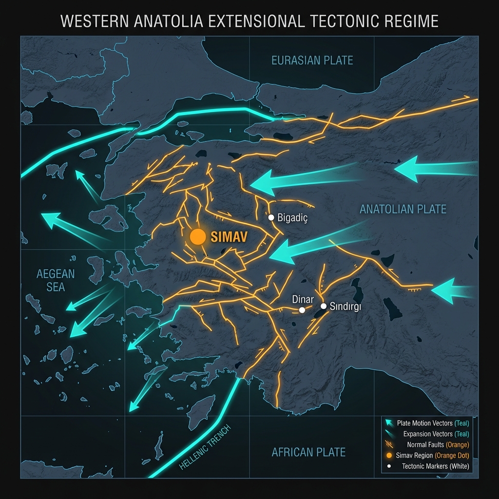
The Simav region sits at a complex geological crossroads where the Aegean Sea’s relentless expansion meets the vast Anatolian plate’s westward escape. Here, the earth’s crust is being pulled apart—stretched by tectonic forces that create networks of normal faults capable of dropping blocks of land downward with sudden, violent releases of energy. Seismologists classify this as an extensional tectonic regime, a setting that generates earthquakes often shallower and more locally intense than those along the better-known strike-slip faults like the North Anatolian Fault to the north.
This restless landscape has a long memory. In 1995, a magnitude 6.4 earthquake struck Dinar, roughly 160 kilometers away, killing dozens and collapsing thousands of buildings. More recently, the region has witnessed a disturbing crescendo: in 2025 alone, magnitude 6.1 and 6.0 earthquakes devastated areas near Bigadiç and Sındırgı, just 88 and 66 kilometers from Simav respectively. These events shattered masonry and triggered landslides, demonstrating that even moderate magnitudes can prove destructive when they strike shallowly beneath populated valleys.
What Does Ten Kilometers Mean for the Shaking?

Depth is destiny in seismology. At just 10 kilometers down, Friday’s earthquake qualifies as shallow-focus—originating within the brittle upper crust where rocks break suddenly and transmit energy efficiently to the surface. When an earthquake strikes this close to the surface, the seismic waves have less time to dissipate before hitting buildings and bedrock, often producing stronger ground motion than a deeper quake of equivalent magnitude.
To understand the context, consider how this event compares to the region’s recent violent history:
| Event | Magnitude | Approximate Depth | Distance from Simav | Year |
|---|---|---|---|---|
| Simav (latest) | 4.7 mb | 10 km | Epicenter | 2026 |
| Simav swarm maximum | 4.8 | 9 km | <10 km | 2026 |
| Bigadiç earthquake | 6.1 | Shallow | 88 km | 2025 |
| Sındırgı earthquake | 6.0 | Shallow | 66 km | 2025 |
| Dinar earthquake | 6.4 | Shallow | 160 km | 1995 |
While the magnitude 4.7 event lacks the raw energy of the 2025 magnitude-6-plus shocks—each step up the magnitude scale represents roughly 32 times more energy release—its proximity to the surface means residents likely experienced sharp, abrupt jolts rather than the rolling sway of deeper tremors. Reports from the region suggest the shaking was felt distinctly in Simav and surrounding villages, a reminder that magnitude alone tells only part of the story.
Are We Watching a Swarm, or a Warning?
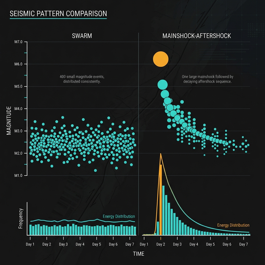
Seismologists distinguish between earthquake swarms—clusters of quakes without a clear mainshock—and foreshock sequences that precede larger events. The Simav pattern, with nearly 400 earthquakes in a week and the largest registering 4.8, fits the classic definition of a swarm: a prolonged, energetic chatter of the crust rather than the clear crescendo-decay pattern of a mainshock-aftershock sequence. This type of earthquake tells us that the crust is adjusting to accumulated strain, bleeding off energy through countless small ruptures rather than storing it for one catastrophic break.
Yet the proximity to the 2025 magnitude-6-plus ruptures complicates the picture. Historical precedent haunts the region; the 1999 magnitude 7.6 Izmit earthquake, which killed over 17,000 people, occurred just 187 kilometers from Simav and followed years of escalating seismicity along its fault segment. While no direct causal link has been established between this swarm and the 2025 events, seismologists monitor such clusters for changes in frequency, depth, or magnitude that might signal a shift toward larger failure. For now, the earth is speaking in murmurs rather than shouts—but in this part of Turkey, every murmur merits close attention.
Frequently Asked Questions
How strong was this earthquake?
The April 11 earthquake registered magnitude 4.7 on the body-wave magnitude scale (mb), making it a light-to-moderate event. While capable of knocking objects from shelves and causing minor structural damage in poorly constructed buildings, it is roughly 60 times less energetic than the magnitude 6.0 earthquakes that struck the region in 2025.
Is there a tsunami risk from this earthquake?
No. According to USGS data, this event poses no tsunami threat. Earthquakes must typically exceed magnitude 6.5 and occur beneath the ocean floor or along coastlines with significant vertical seafloor displacement to generate destructive ocean waves. Simav lies inland, approximately 100 kilometers from the Aegean coast.
Why is this area so seismically active?
Western Turkey sits within one of the world’s most tectonically complex zones, where the African plate subducts beneath the Aegean while the Anatolian plate grinds westward against Eurasia. This creates extensional forces that pull the crust apart, generating shallow, damaging earthquakes along normal faults like those near Simav. The region has produced multiple magnitude-6-plus events in recent decades, including the destructive 2025 Bigadiç and Sındırgı earthquakes.
Track this event live on the map!
Download GeoShake and get instant earthquake alerts.
Download GeoShake