
The ground didn’t just shake—it lurched. At 2:31 p.m. local time on April 11, a magnitude 4.8 earthquake ruptured just 9.12 kilometers beneath the surface near Simav, a district in Turkey’s Kütahya province, according to USGS data. That shallow depth meant the seismic energy had little room to dissipate before reaching the streets above, amplifying the jolt felt by residents across the region.
Why Is Western Turkey So Prone to Seismic Surprises?
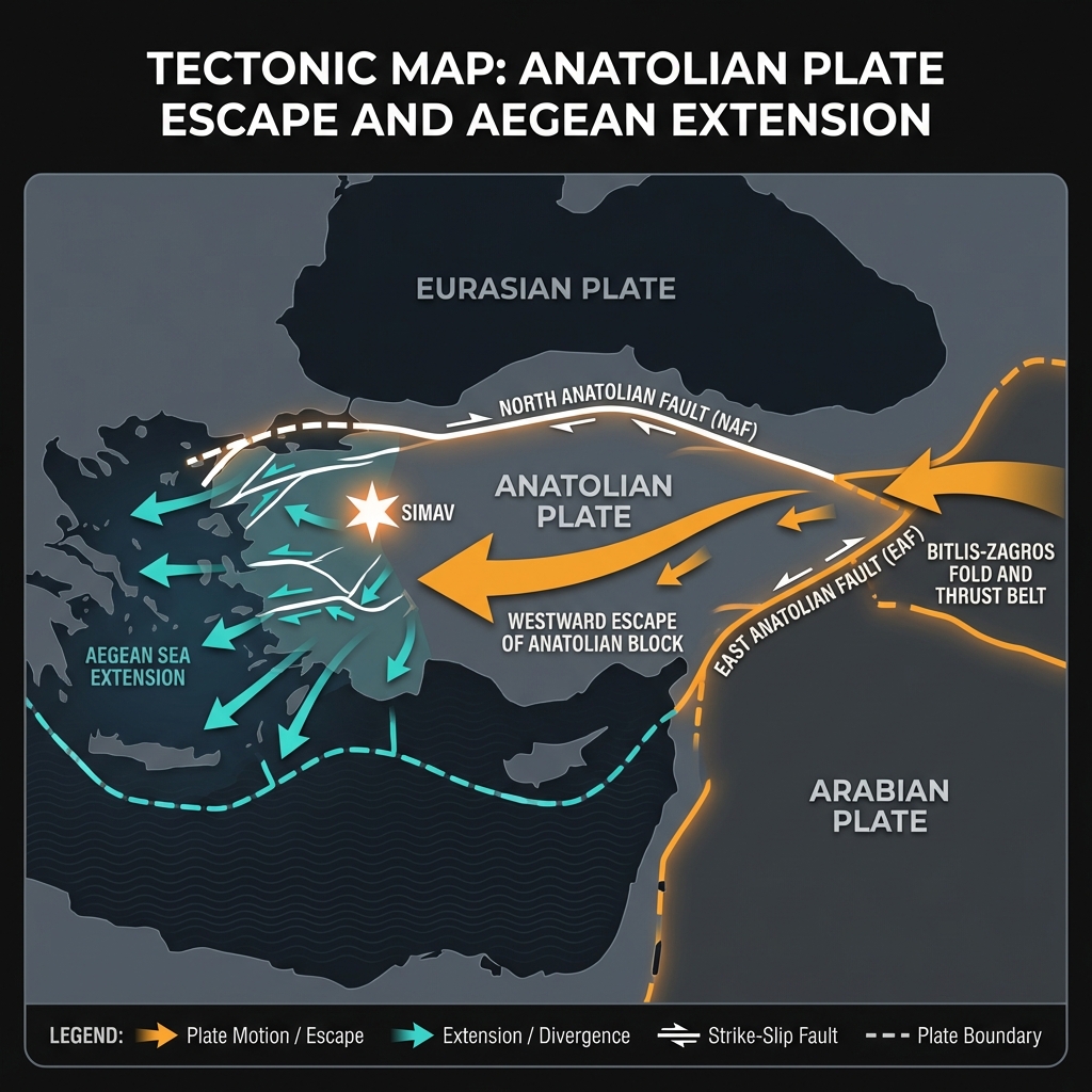
This corner of Turkey sits at one of the planet’s most complex geological crossroads. The Anatolian plate, essentially a wedge of continental crust, is being squeezed westward between the converging Eurasian and Arabian plates while the Aegean Sea pulls away to the west. Seismologists classify this as a transtensional regime—where tectonic forces simultaneously slide past each other and pull apart—creating a fragmented landscape of grabens and fault blocks.
Simav itself lies near the western end of this tectonic conveyor belt, not far from the North Anatolian Fault’s western reaches and the extensional basins of the Aegean. The region has a long memory of destruction: the devastating 1999 M7.6 Izmit earthquake struck just 183 kilometers to the northeast, while the 1995 M6.4 Dinar earthquake occurred 166 kilometers to the southeast.
More recently, the area has been rattled by significant events including a M6.1 quake near Bigadiç in 2025, just 83 kilometers away, and a M6.0 event near Sındırgı, a mere 63 kilometers distant. Today’s tremor arrives amid an intense seismic swarm—384 earthquakes have shaken this 200-kilometer radius in the past week alone—suggesting the crust is actively adjusting to these persistent tectonic pressures.
| Event | Year | Magnitude | Distance from Simav |
|---|---|---|---|
| Izmit | 1999 | M7.6 | 183 km |
| Dinar | 1995 | M6.4 | 166 km |
| Bigadiç | 2025 | M6.1 | 83 km |
| Sındırgı | 2025 | M6.0 | 63 km |
What Does a 9-Kilometer Depth Mean for Shaking?
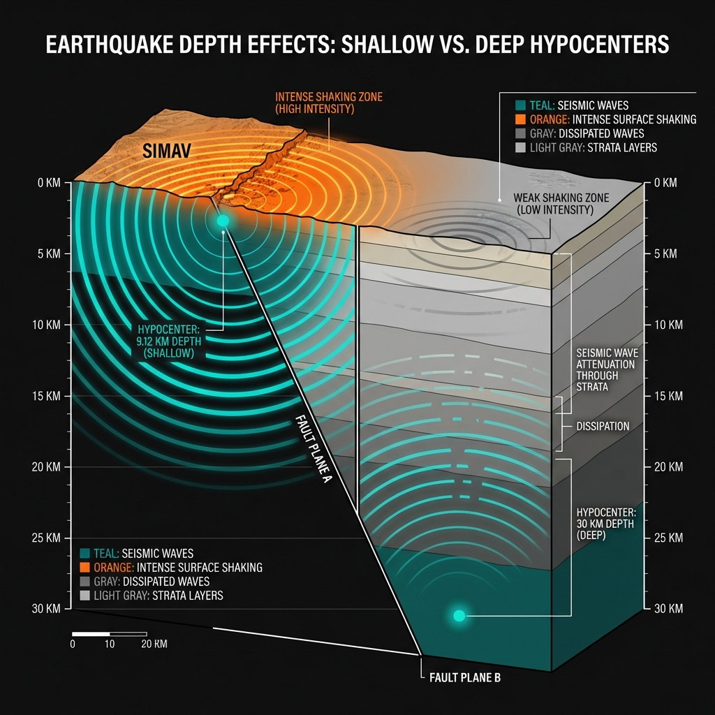
Depth is everything in earthquake impact. At 9.12 kilometers, this event qualifies as shallow-focus—occurring in the upper crust where rocks are brittle and capable of storing tremendous elastic strain. When that strain releases, the energy travels a relatively short distance to the surface, arriving with less attenuation than it would from a deeper quake. Seismologists estimate that shaking intensity decreases roughly with distance from the hypocenter, so a shallow M4.8 can feel significantly more violent than a deep M5.5.
To put this in perspective, the energy released—roughly equivalent to 1,000 tons of TNT—was concentrated in the uppermost crust. Residents likely experienced strong shaking (Modified Mercalli Intensity VI), capable of rattling dishes and disturbing furniture, though structural damage typically begins at higher intensities. The shallow depth also means the rupture likely occurred on a local fault within the Simav graben or nearby structural features, rather than on one of the major through-going faults that define Turkey’s tectonic map.
What Should We Expect in the Coming Days?
When the earth produces a magnitude 4.8 event at such a shallow depth, aftershocks are almost certain. Seismologists monitoring the region will be watching for smaller earthquakes—typically one magnitude unit lower than the mainshock—as the fault plane settles and stress redistributes to adjacent rock volumes. Given the current swarm activity, with hundreds of micro-tremors recorded this week alone, the crust here is clearly in an active phase of deformation.
Residents should remain aware that while a single M4.8 event rarely causes catastrophic damage, it serves as a reminder that western Turkey’s seismic clock is always ticking. The proximity to recent larger events—the 2025 Bigadiç and Sındırgı earthquakes—suggests this region is working through a sequence of stress releases. GeoShake will continue monitoring for any changes in the swarm pattern that might indicate escalating risk.
Frequently Asked Questions
How strong was this earthquake?
A magnitude 4.8 earthquake releases approximately 1,000 tons of TNT equivalent energy. At the shallow depth of 9.12 kilometers, this produced strong shaking capable of rattling windows and disturbing loose objects, though significant structural damage is uncommon at this magnitude unless building codes are compromised.
Is there a tsunami risk from this event?
No. This earthquake occurred inland within the Anatolian peninsula, far from any coastline. Additionally, tsunamis require specific conditions—typically submarine earthquakes with significant vertical seafloor displacement—criteria not met by this shallow continental rupture.
Why is this area so seismically active?
Western Turkey sits at the intersection of the Eurasian, African, and Arabian plates, where the Anatolian block is being pushed westward while the Aegean region extends and thins. This creates a complex zone of active faulting, making the region one of the most earthquake-prone areas in the Mediterranean.
Track this event live on the map!
Download GeoShake and get instant earthquake alerts.
Download GeoShake