
Just 23 kilometers from the epicenter of a devastating magnitude 7.8 earthquake that was 63 times more powerful, a moderate offshore tremor rattled the same volatile subduction zone near Vanuatu on March 25, 2026. The magnitude 4.9 event struck at 3:33 PM UTC approximately 193 kilometers north-northwest of Sola, Vanuatu, at a depth of 94 kilometers beneath the Pacific seafloor, according to USGS data. While the tremor caused no reported damage or tsunami threat, its proximity to the site of the 2009 disaster underscores the relentless tectonic forces still accumulating along one of Earth’s most active plate boundaries.
Why Is This Region So Prone to Powerful Quakes?
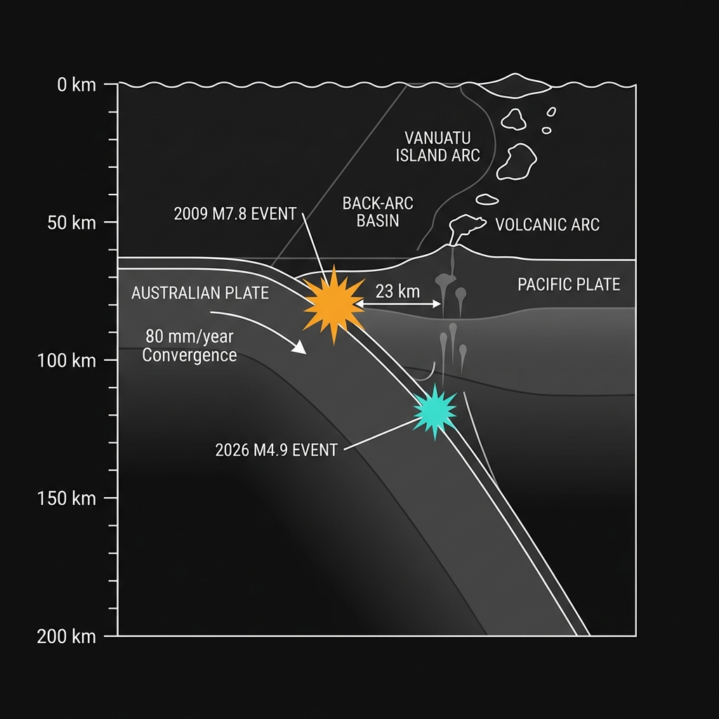
Vanuatu sits atop the New Hebrides subduction zone, where the Australian Plate dives beneath the Pacific Plate at a rate of roughly 80 millimeters per year. This convergence creates a geological pressure cooker: as the dense oceanic crust descends into the mantle, it generates immense friction and strain that periodically releases as earthquakes.
The area has hosted multiple magnitude 7-plus events in recent decades, including a particularly violent sequence in 2009 when the region suffered three major quakes within months. That October, the magnitude 7.8 mainshock struck nearly the exact location as today’s tremor, followed by a magnitude 7.7 and a 7.4 in the surrounding weeks.
| Year | Magnitude | Distance from Sola | Relation to Current Event |
|---|---|---|---|
| 2009 | 7.8 | 196 km NW | 23 km from today’s epicenter |
| 1997 | 7.7 | 171 km NNW | 22 km away; similar magnitude |
| 2009 | 7.7 | 148 km NW | Major aftershock of M7.8 |
| 2009 | 7.4 | 143 km NW | Deep slab rupture |
| 1999 | 7.3 | 146 km NW | Intermediate depth event |
This clustering reveals a harsh reality: the subduction zone stores elastic energy like a coiled spring, and when it uncoils, it often does so in rapid succession. Seismologists classify this as a seismic gap periodically filling, where centuries of plate motion get released in seconds.
What Does This Depth Tell Us About the Shaking?
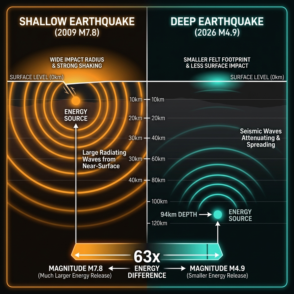
At 94 kilometers beneath the surface, this earthquake qualifies as a “deep-focus” event—originating well within the descending Australian Plate rather than at the shallow crustal boundary. Such depth acts as a natural shock absorber: by the time seismic waves reach the surface, they have spread outward and attenuated significantly.
A shallow magnitude 4.9 earthquake might rattle windows and knock items from shelves nearby, but at this depth, the energy dissipates across a broader area with considerably less violence. The 2009 magnitude 7.8 earthquake, by contrast, ruptured closer to the surface, allowing it to generate intense shaking across hundreds of kilometers despite the relatively small numerical difference in magnitude. Seismologists note that each whole number increase on the magnitude scale represents roughly 32 times more energy release, meaning the 2009 quake dwarfed this recent event by a factor of approximately 63.
Deep events like today’s typically produce minimal surface damage but serve as critical indicators of ongoing stress within the subducting slab. The rupture likely occurred as the descending plate encountered increasing heat and pressure, causing brittle fracture deep within the mantle.
What Should We Watch For Next?
While deep earthquakes of this magnitude rarely trigger tsunamis or significant damage, they serve as vital reminders that the New Hebrides subduction zone remains loaded with potential energy. Geoscientists will monitor whether this event represents isolated stress release or precedes a period of increased activity, as the region has shown propensity for earthquake swarms—most notably the 2009 sequence that saw three magnitude 7-plus events within a single year.
For residents of Vanuatu and the broader Pacific, this tremor reinforces the necessity of robust building codes and tsunami preparedness, because while today’s shake was gentle, the same fault system has demonstrated it can generate events thousands of times more powerful. The Pacific’s “Ring of Fire” offers no pause in its geological cycle, and this latest rumble serves as another data point in the long-term monitoring of a boundary that will inevitably produce another major disaster.
Frequently Asked Questions
How strong was this earthquake?
The event registered as magnitude 4.9 on the moment magnitude scale, classifying it as a light to moderate earthquake. Because it occurred at a depth of 94 kilometers, the shaking at the surface was significantly dampened compared to a shallow quake of the same size, limiting felt effects to minor vibrations rather than structural damage.
Is there a tsunami risk from this event?
No tsunami warning was issued for this earthquake. Deep-focus events like this one rarely displace enough seafloor volume to generate tsunamis, and the magnitude 4.9 energy release falls well below the threshold typically associated with ocean-wide wave generation, particularly given its location far offshore.
Why is this area so seismically active?
Vanuatu lies along the New Hebrides subduction zone, where the Australian Plate collides with and dives beneath the Pacific Plate at high velocity. This convergent boundary generates frequent earthquakes as the descending slab fractures and grinds against the overlying plate, creating one of the most active seismic regions in the Pacific Ring of Fire with a documented history of magnitude 7-plus events occurring roughly every few years.
Track this event live on the map!
Download GeoShake and get instant earthquake alerts.
Download GeoShake