
Ten kilometers below the surface of southern Azerbaijan, the Earth ruptured with lethal proximity to the surface. The shallow depth of this morning’s magnitude 5.6 earthquake—striking at 09:05 UTC roughly 64 kilometers southeast of Sovetabad, near the Iranian border—transforms what might otherwise be a moderate tremor into a genuine threat to buildings and infrastructure, according to USGS data. With the hypocenter sitting at the upper boundary of the seismogenic layer, nearly all of the event’s seismic energy had minimal rock to dissipate through before hammering the surface.
Why Is This Region So Seismically Active?
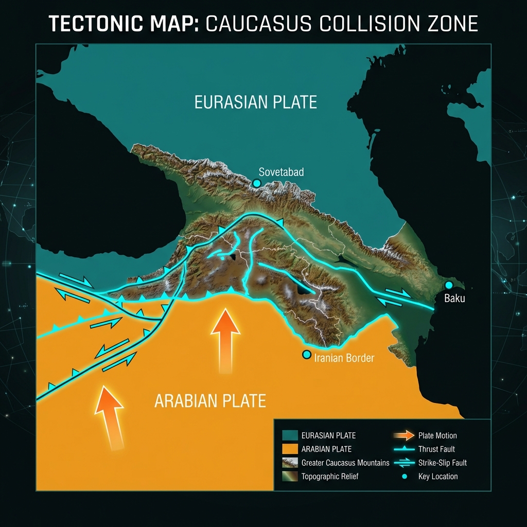
This corner of the Caucasus sits at the brutal convergence of the Arabian and Eurasian tectonic plates, a continental collision zone that has thrust the Greater Caucasus Mountains skyward over millions of years. Unlike the clean subduction zones found along oceanic trenches, this is a messy tectonic battleground where crustal blocks rotate, thrust faults stack like cards, and strike-slip systems slice through the landscape. The region carries the memory of past devastation: in November 2000, a sequence of powerful earthquakes struck near Baku, including a magnitude 6.8 event that killed dozens and left thousands homeless, followed weeks later by a magnitude 6.5 aftershock that compounded the destruction.
Recent activity suggests a quiet prelude to today’s event, with no recorded earthquakes exceeding magnitude 2.5 in the immediate 200-kilometer radius during the past seven days. This seismic silence may have allowed stress to accumulate on shallow faults near the Iranian frontier, away from the more frequently rupturing structures closer to the Caspian coast.
What Does This Depth Mean for Ground Shaking?
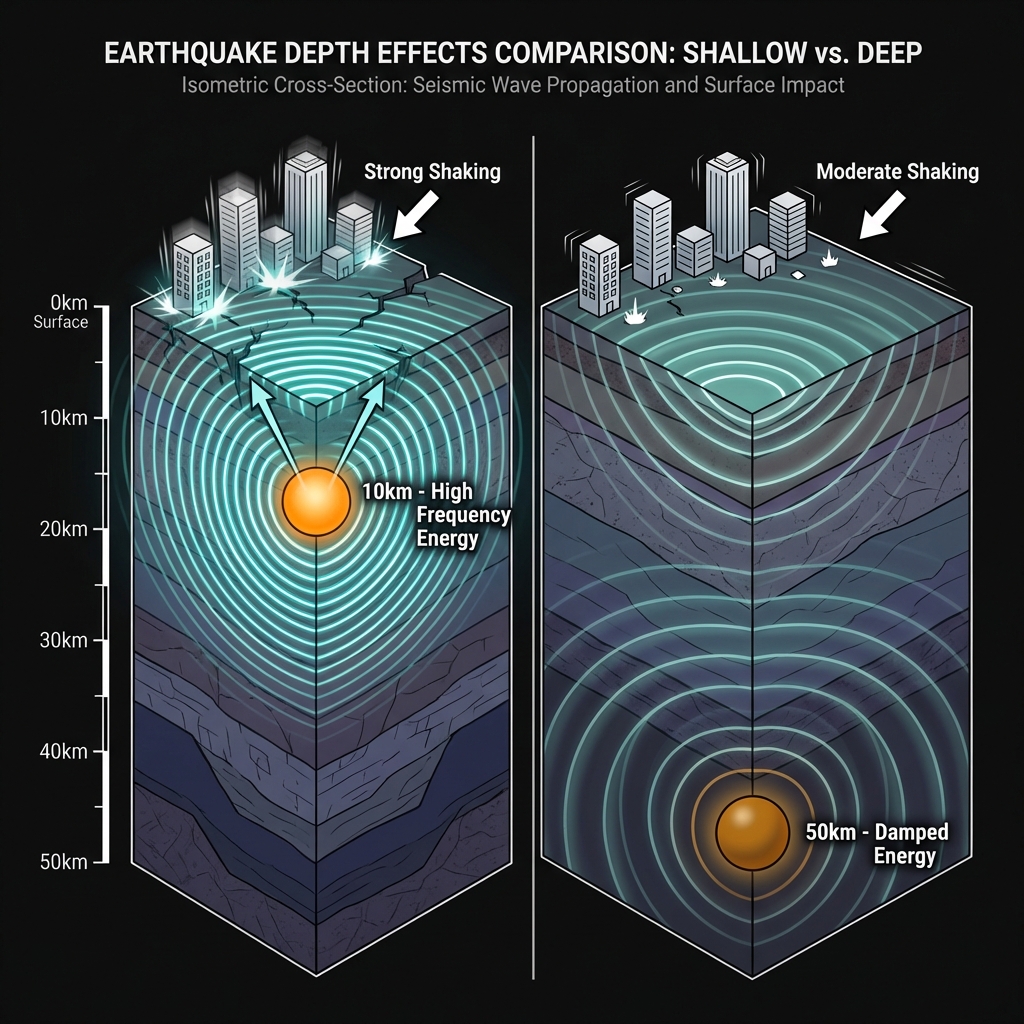
Seismologists classify earthquakes at depths of less than 70 kilometers as “shallow,” but the difference between a 10-kilometer and a 50-kilometer event is the difference between a punch and a push. At this shallow depth—comparable to the cruising altitude of a commercial airliner—seismic waves retain their high-frequency energy, creating the sharp, jolting motion most damaging to low-rise buildings and unreinforced masonry. Residents likely experienced Modified Mercalli Intensity VI to VII shaking near the epicenter, meaning strong enough to crack plaster, dislodge bricks, and potentially shift poorly anchored structures.
This type of earthquake tells us the brittle upper crust is accommodating stress directly, without the damping effect of deeper, more ductile rock. Seismologists note that while a magnitude 5.6 releases roughly thirty times less energy than the magnitude 6.8 Baku disaster, the shallow focus means peak ground accelerations could locally approach damaging levels similar to those felt much farther from deeper, larger events.
| Event | Year | Magnitude | Depth | Approx. Distance from Today’s Epicenter |
|---|---|---|---|---|
| Today’s earthquake | 2026 | 5.6 | 10 km | — |
| Baku mainshock | 2000 | 6.8 | ~30 km | 159 km |
| Badamdar earthquake | 2000 | 6.5 | ~35 km | 151 km |
| Lerik earthquake | 1998 | 6.0 | 10 km | 96 km |
The table reveals a sobering pattern: while today’s event is smaller in magnitude than the catastrophic 2000 sequence, it shares the dangerously shallow character of the 1998 Lerik earthquake, which caused significant damage in southern Azerbaijan despite its moderate size.
What Should Residents Do?
Residents in the epicentral region should immediately inspect load-bearing walls and foundations for fresh cracks or displaced masonry, as shallow earthquakes often reveal structural weaknesses that deeper tremors mask. Given the proximity to the Iranian border, communities in both nations should maintain emergency communication plans and secure water supplies, while avoiding damaged buildings during inevitable aftershocks. Unlike the 2000 Baku sequence, which saw a larger mainshock followed by damaging aftershocks, this event’s moderate magnitude means it could itself be a foreshock—requiring 24-48 hours of heightened vigilance and sleeping away from heavy furniture or exterior walls.
What Should We Watch For?
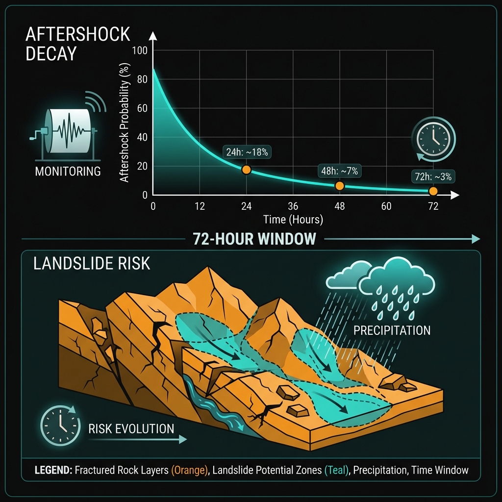
Seismologists will monitor the next 72 hours for aftershocks, which in shallow continental settings typically trend one magnitude unit smaller than the mainshock. The region’s rugged topography south of Sovetabad raises concerns for earthquake-triggered landslides, particularly if aftershocks or spring rains destabilize slopes already fractured by today’s shaking. GeoShake will continue tracking whether this isolated event represents the reawakening of local fault segments or simply the ongoing background stress release that characterizes this restless corner of the collision zone.
Frequently Asked Questions
How strong was this earthquake?
The earthquake registered as magnitude 5.6 on the moment magnitude scale, a moderate event that released energy equivalent to approximately 3,000 tons of TNT. However, its shallow depth of just 10 kilometers concentrated this energy near the surface, potentially causing localized damage comparable to much larger but deeper earthquakes felt at greater distances.
Is there a tsunami risk?
No tsunami warning has been issued for this event. The earthquake occurred deep within the continental interior of Azerbaijan, far from the Caspian Sea coastline and with no mechanism to displace a significant volume of water. Tsunamis require submarine thrust faults or large underwater landslides, neither of which characterize this shallow crustal rupture near the Iranian border.
Why is this area so seismically active?
This region sits at the collision boundary between the Arabian and Eurasian tectonic plates, where continental crust crumples and fractures under immense north-south compression. The ongoing mountain-building process that created the Caucasus range continues to generate earthquakes as faults slip to accommodate the convergence, making this one of the most tectonically complex and hazardous regions in Western Asia.
Track this event live on the map!
Download GeoShake and get instant earthquake alerts.
Download GeoShake