
Residents of Tabonok, a municipality in Cebu Province, felt the earth lurch without warning early Sunday morning as a shallow magnitude 5.2 earthquake struck directly beneath their community. The tremor hit at a depth of just 10 kilometers, making it a crustal event capable of producing sharp, localized shaking despite its moderate magnitude, according to USGS data.
Why Is This Archipelago So Prone to Quakes?
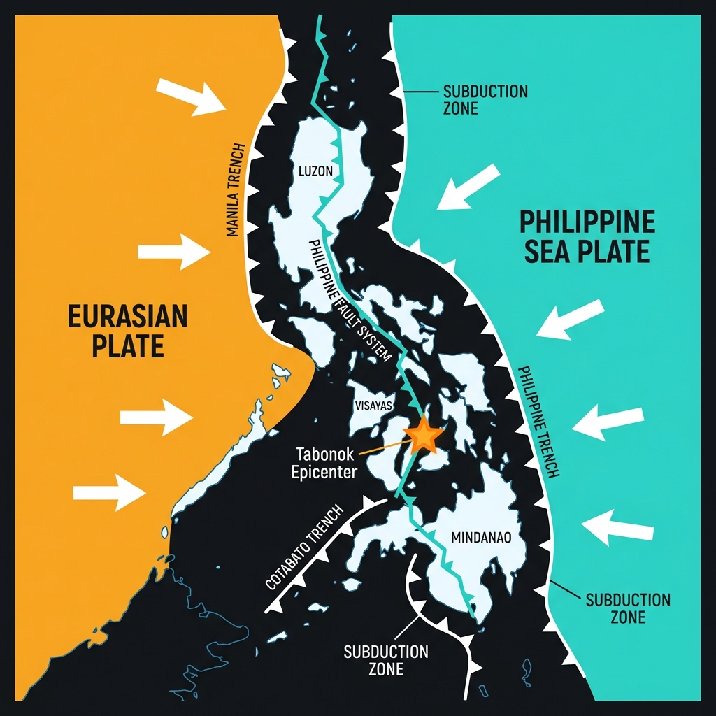
The Philippines sits astride the Pacific Ring of Fire, a volatile belt where tectonic plates grind against one another with relentless pressure. Here, the Philippine Sea Plate converges with the Eurasian Plate, creating a complex network of subduction zones and strike-slip faults that crisscross the archipelago like geological scars. Seismologists classify this region as one of the most seismically hazardous on Earth, where the accumulated strain of centuries can release in sudden, violent lurches.
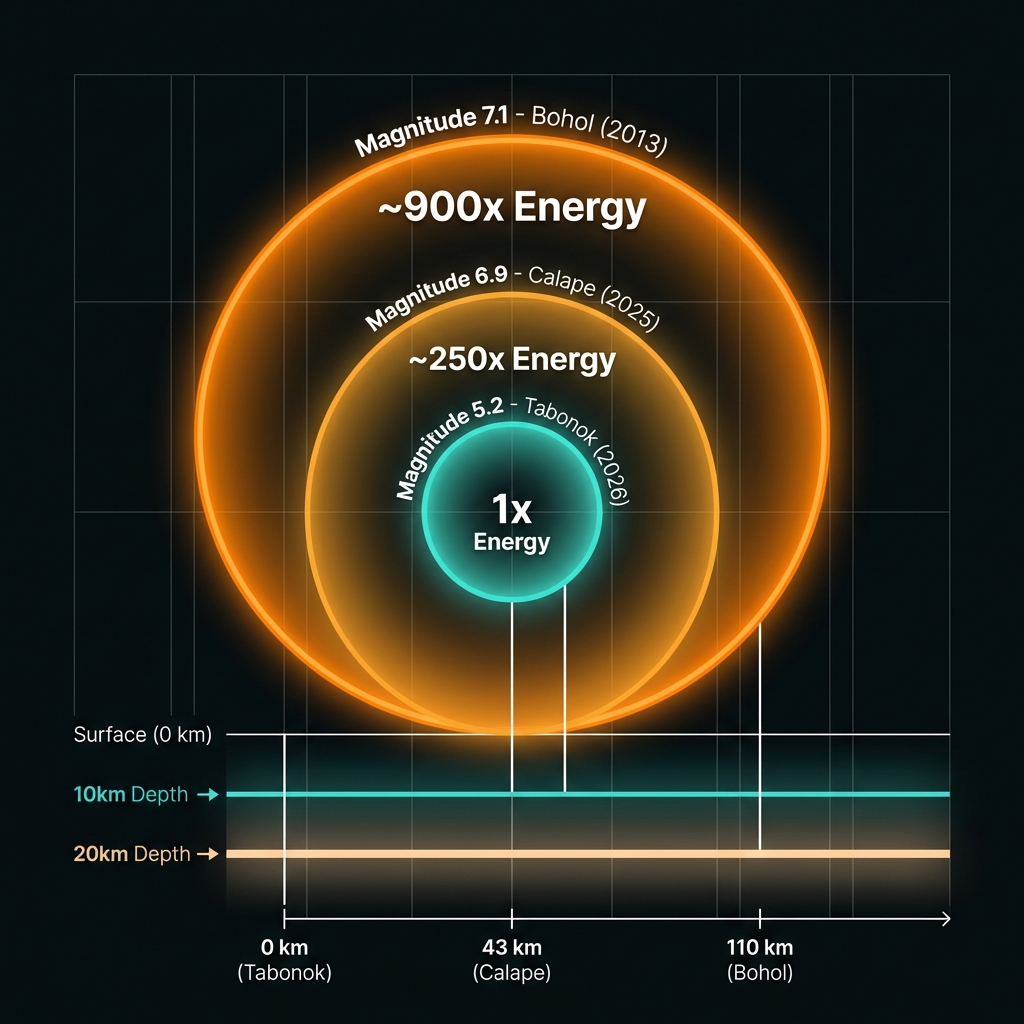
The epicenter near Tabonok lies within this intricate tectonic mosaic, specifically influenced by the Philippine Fault System—a massive left-lateral strike-slip structure that runs the length of the country. While not as famous as the San Andreas Fault, this system generates significant earthquakes as the plates slide past one another horizontally. Historical records remind us that this area carries memory of devastation; the 2013 magnitude 7.1 Bohol earthquake originated just 110 kilometers southeast of Sunday’s event, killing over 200 people and causing widespread liquefaction. More recently, a magnitude 6.9 tremor struck near Calape in 2025, just 43 kilometers away, demonstrating that the crust here remains under constant stress.
How Intense Was the Ground Motion?
At magnitude 5.2, Sunday’s earthquake falls into the “moderate” category on the moment magnitude scale, yet its shallow depth of 10 kilometers significantly amplifies its impact at the surface. Seismologists calculate that such shallow events generate higher peak ground accelerations than deeper quakes of similar magnitude, translating to more violent perceived shaking for nearby populations. Residents likely experienced Modified Mercalli Intensity (MMI) levels of VI to VII in the immediate epicentral region—strong enough to crack walls, displace unsecured objects, and alarm the population, though typically not causing catastrophic structural failure in well-built infrastructure.
To contextualize this event against the region’s violent history, consider the following comparison of significant nearby earthquakes:
| Event | Year | Magnitude | Depth | Distance from Tabonok | Impact |
|---|---|---|---|---|---|
| Bohol Earthquake | 2013 | 7.1 | 20 km | 110 km | 222 deaths, widespread building collapse |
| Calape Event | 2025 | 6.9 | 10 km | 43 km | Significant local damage |
| Tabonok (This Event) | 2026 | 5.2 | 10 km | 0 km | Localized strong shaking |
The 2013 Bohol event released approximately 900 times more energy than Sunday’s tremor, illustrating why magnitude differences matter exponentially. However, proximity matters too; being directly atop a magnitude 5.2 quake often feels more violent than distant shaking from a much larger event. Unlike the 2013 earthquake, which occurred in a relatively quiet seismic period for the region, Sunday’s tremor arrives as a solitary event—the only magnitude 5+ earthquake recorded within 200 kilometers during the past seven days.
What Should We Expect Next?
Aftershocks remain a possibility following shallow crustal earthquakes, though the absence of preceding seismic activity suggests this may be an isolated stress release rather than the mainshock of a developing swarm. Seismologists will monitor the region for smaller tremors in the coming days, particularly any events exceeding magnitude 3.0 that might indicate continued adjustment along the fault plane. For residents, this event serves as a reminder that the Philippine Fault System stores centuries of tectonic stress, and while magnitude 5 events cause alarm, the region’s geological history warns that significantly larger ruptures remain possible.
Frequently Asked Questions
How strong was this earthquake?
The earthquake registered as magnitude 5.2 on the moment magnitude scale (Mww), classifying it as a moderate event. Because it occurred at a shallow depth of only 10 kilometers, the shaking felt at the surface was significantly stronger than it would have been for a deeper quake of the same magnitude.
Is there a tsunami risk from this earthquake?
No tsunami warning was issued for this event. According to USGS data, the earthquake’s magnitude and fault mechanism did not generate sufficient vertical seafloor displacement to displace a large volume of water. Additionally, the epicenter was located inland on the island of Cebu, reducing any potential oceanic threat.
Why is this area so seismically active?
The Philippines sits on the Pacific Ring of Fire where the Philippine Sea Plate and Eurasian Plate collide. This region features the Philippine Fault System, a major strike-slip boundary, and multiple subduction zones that create constant tectonic pressure. Historical events like the 2013 magnitude 7.1 Bohol earthquake demonstrate that this area experiences significant seismic cycles regularly.
Track this event live on the map!
Download GeoShake and get instant earthquake alerts.
Download GeoShake