
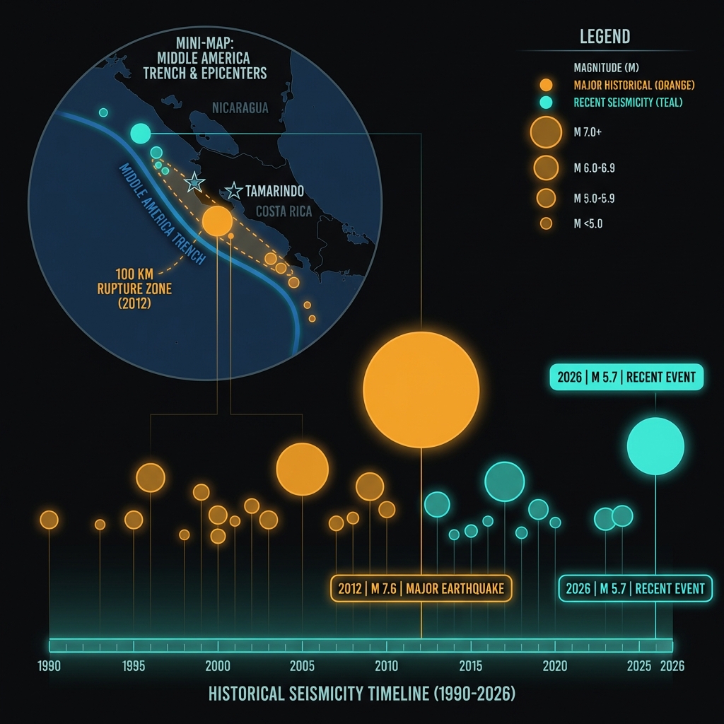
At just 20 kilometers beneath the surface—shallow enough to feel like a direct jolt rather than a distant rumble—a magnitude-5.7 earthquake struck off Costa Rica’s Pacific coast early Wednesday morning, sending tremors through the tourist hub of Tamarindo and surrounding communities. The quake occurred approximately 72 kilometers southwest of the popular beach destination at 06:56 UTC on April 15, according to USGS data, placing it within the same volatile subduction zone that produced a destructive magnitude-7.6 temblor in 2012.
Why Is This Region a Hotbed for Powerful Quakes?
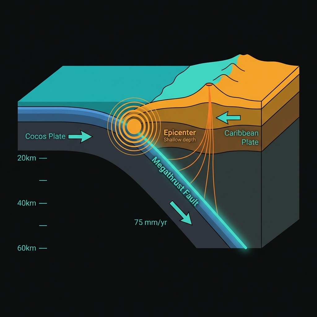
The answer lies beneath the waves, where the Cocos Plate dives beneath the Caribbean Plate in a relentless geological process called subduction. This collision creates the Middle America Trench, an underwater chasm that runs parallel to Costa Rica’s Pacific coastline and generates some of the most powerful earthquakes in the Western Hemisphere.
The region has a long memory of destruction. In September 2012, just 118 kilometers from Tamarindo, a magnitude-7.6 earthquake struck near Hojancha, killing two people and damaging hundreds of structures. That event released roughly 1,000 times more energy than Wednesday’s quake. Seismologists note that the 2012 rupture occurred on the same megathrust fault system that produced Wednesday’s tremor, though this smaller event likely represents a stress adjustment within the overriding plate rather than a major movement of the main subduction interface itself. This convergence has sculpted the region’s dramatic coastline while simultaneously loading the geological spring that drives major seismic events, with the 2012 earthquake alone rupturing a 100-kilometer stretch of the fault interface.
How Violent Was the Shaking?
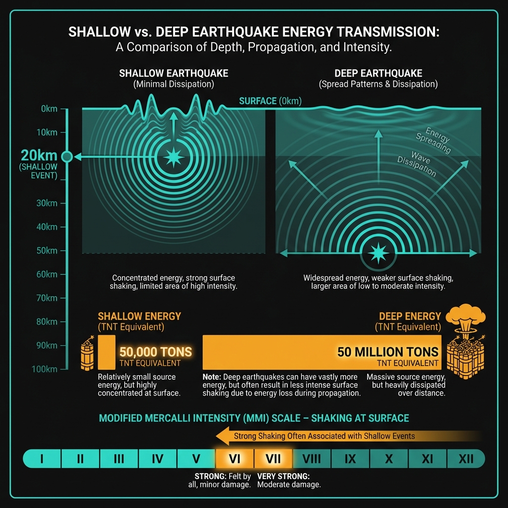
At twenty kilometers depth, this earthquake qualifies as shallow—meaning the energy had minimal rock to absorb it before reaching the surface. Seismologists classify events less than 70 kilometers deep as shallow, but those under 25 kilometers often produce the most intense local shaking because the seismic waves haven’t spread out and weakened significantly through the earth’s crust.
For residents in Tamarindo and surrounding Guanacaste communities, the shaking likely felt like a sharp jolt followed by rolling motion. A magnitude-5.7 releases energy equivalent to approximately 50,000 tons of TNT—powerful enough to knock items from shelves and cause minor structural damage in poorly constructed buildings. Those near the epicenter likely experienced Modified Mercalli Intensity levels of VI to VII, strong enough to cause chandeliers to swing and standing vehicles to rock noticeably. By comparison, the 2012 magnitude-7.6 released energy equivalent to nearly 50 million tons. The tremors were likely perceptible across much of Costa Rica’s Nicoya Peninsula and possibly into southern Nicaragua, though the offshore location provided some buffer against the most severe impacts.
What Should Residents Do Right Now?
In the immediate aftermath, residents should inspect homes and businesses for fresh cracks in walls, displaced roof tiles, or damaged utility lines that could pose fire or electrocution hazards. Given the region’s history and the shallow depth of this event, magnitude-4-plus aftershocks are likely in the coming days, warranting that heavy furniture remain secured and emergency kits stay accessible near exits. While the USGS confirms no tsunami threat from this particular earthquake, coastal residents should use this reminder to verify evacuation route signage and ensure emergency supplies include at least three days of water and non-perishable food, as the subduction zone remains capable of generating larger tsunamigenic events.
What Should We Watch For Next?
GeoShake monitoring systems will track the area closely for aftershocks, which typically decay in frequency and magnitude over days to weeks. However, seismologists remain vigilant because shallow moderate earthquakes in subduction zones sometimes foreshadow larger events, as stress transfers along the plate interface. The 2012 magnitude-7.6 followed a similar pattern of increasing regional activity, though such sequences remain impossible to predict with precision. Residents should treat this as a wake-up call to review structural integrity, particularly in older buildings constructed before modern seismic codes were enforced across Guanacaste Province.
| Year | Magnitude | Location | Distance from Tamarindo |
|---|---|---|---|
| 2026 | 5.7 | 72 km SW of Tamarindo | 72 km |
| 2012 | 7.6 | 11 km ENE of Hojancha | 118 km |
| 1990 | 7.3 | 7 km SSE of Puntarenas | 172 km |
| 2022 | 6.6 | 55 km WSW of Masachapa, Nicaragua | 193 km |
| 2014 | 6.6 | 15 km N of Belén, Nicaragua | 200 km |
| 2005 | 6.6 | 32 km W of San Juan del Sur, Nicaragua | 150 km |
Frequently Asked Questions
How strong was this earthquake?
The earthquake registered as magnitude 5.7 according to USGS data, making it a moderate but potentially damaging event given its shallow depth of 20 kilometers. This puts it in the “strong” category on the Modified Mercalli Intensity scale, capable of causing minor to moderate damage in poorly built structures near the epicenter while being felt over a wide area of Costa Rica’s Pacific coast.
Is there a tsunami risk?
No tsunami warning has been issued for this event. The earthquake occurred at a depth and location that did not generate significant vertical seafloor displacement, and the Pacific Tsunami Warning Center confirmed no threat to coastal communities in Costa Rica or neighboring countries, though the region remains capable of producing tsunamigenic earthquakes.
Why is this area so seismically active?
This region sits atop the Middle America Trench, where the oceanic Cocos Plate slides beneath the Caribbean Plate at a rate of approximately 75 millimeters per year. This subduction process creates enormous pressure that periodically releases as earthquakes, explaining why this area has produced multiple magnitude-7-plus events over the past four decades including the devastating 2012 magnitude-7.6 earthquake near Hojancha.
Track this event live on the map!
Download GeoShake and get instant earthquake alerts.
Download GeoShake